Wooden posts and palisade protected by an earthwork
Garrison information
Occupants
no categorisation
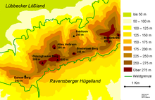
The Babilonie is a hillfort of the La Tène culture at a height of 255.6 metres above sea level on the northern edge of a rounded hill in the Wiehen Hills above the Lübbecke village of Obermehnen in the district of Minden-Lübbecke in the German state of North Rhine-Westphalia. The name is derived from the Germanic baben in the lon i.e. "up in the woods".
Relief map of the Wiehen around the Babilonie
The wedge-shaped, double-rampart system, which descends from south to north with the slope, was investigated archaeologically in the first half of the last century, especially by Friedrich Langewiesche, who assessed it as a refuge castle.
Ceramic and even metalwork finds indicate that it belongs to the La Tène culture in the pre-Roman Iron Age, e vorrömische Eisenzeit, therefore probably part of an extensive trading network. The fortification has an area of over 12 hectares. The first mapping of this hilltop, which was exceptionally well-suited to the establishment of a large hillfort with its spring high up the hills, was carried out after 1880.[1]
Ceramic finds from the Saxon-Frankish period have also been discovered.
According to Paul Höfer there is a legend that refers to Wittekind.[2]
Sources
Torsten Capelle: Wallburgen in Westfalen-Lippe. Herausgegeben von der Altertumskommission für Westfalen, Münster, 2010, ISSN 0939-4745, p. 22f. No. FBW 12 (Frühe Burgen in Westfalen Sonderband 1)
References
^Heinrich Schmidt: Die Babilonie in Geschichte und Sage. In: Gemeinde Blasheim (pub.): 969-1969. 1000 Jahre Gemeinde Blasheim. Druck: Bruns, Minden o. J. (1969), p. 84-89.
^Paul Höfer: Der Feldzug des Germanicus Im Jahre 16. n.Chr. 1884, p. 88