Cantal, Saskatchewan
Community in Saskatchewan, Canada
Unincorporated community Block settlement in Saskatchewan, Canada
49°26′02″N 101°56′06″W / 49.43389°N 101.93500°W / 49.43389; -101.93500Cantal is an unincorporated community, within the Rural Municipality of Reciprocity No. 32, Saskatchewan, Canada. The community is located 4 km north of Highway 361 on Range Road 340, (49.433998, -101.934873)[4] approximately 103 km east of the city of Estevan. Farming and oil are the major local industries.
Gallery
A gallery of photos from Cantal, Saskatchewan
-
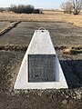 School site in Cantal, Saskatchewan
 -
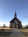 St. Raphael Church in Cantal, Saskatchewan


See also
References
- ^ National Archives, Archivia Net. "Post Offices and Postmasters". Archived from the original on October 6, 2006. Retrieved August 21, 2014.
- ^ Government of Saskatchewan, MRD Home. "Municipal Directory System". Archived from the original on January 15, 2016. Retrieved August 21, 2014.
- ^ "2011 Community Profiles". Statistics Canada. Government of Canada. Archived from the original on December 26, 2018. Retrieved August 21, 2014.
- ^ Google Maps - Cantal, Saskatchewan
External links
 Media related to Cantal, Saskatchewan at Wikimedia Commons
- v
- t
- e
Subdivisions of Saskatchewan
- Culture
- Economy
- First Nations
- Geography
- Government
- History
- Regions
- Tourist attractions
 Category
 Canada portal
 WikiProject


| |||||
|---|---|---|---|---|---|
| Cities |  | ||||
| Towns | |||||
| Villages | |||||
| Rural municipalities | |||||
| First Nations | |||||
| Indian reserves | |||||
| Unincorporated communities |
| ||||
 | This article about a location in the Census Division No. 1 of Saskatchewan is a stub. You can help Wikipedia by expanding it. |
- v
- t
- e


