Capitol Butte
Summit in Arizona, United States


Capitol Butte
Location in Arizona
Show map of Arizona
Capitol Butte
Capitol Butte (the United States)
Show map of the United StatesSchnebly Hill Formation
Capitol Butte is a 6,355-foot-elevation (1,937-meter) summit in Yavapai County, Arizona, United States.
Description
Capitol Butte is located three miles immediately northwest of Sedona in the Red Rock-Secret Mountain Wilderness, on land managed by Coconino National Forest. The nearest higher neighbor is Lost Wilson Mountain 3.1 miles (5 km) to the north-northeast.[1][4] Precipitation runoff from this feature drains to Oak Creek which is part of the Verde River watershed.[4] Topographic relief is significant as the summit rises over 1,700 feet (518 meters) above West Sedona in 0.6 mile (1 km). Capitol Butte is composed of light-colored Coconino Sandstone overlaying reddish Schnebly Hill Formation.[5]
Etymology
The landform's toponym was officially adopted in 1971 by the United States Board on Geographic Names.[2] It is unknown how the butte came to be called "Capitol,"[6] however it does resemble a capitol dome in appearance.[7] Previous variant names for the landform included Capital Butte, Gray Mountain, Grayback Mountain, and Judge Oteys Tombstone.[3] Locals call it "Thunder Mountain."[8]
Climate
According to the Köppen climate classification system, Capitol Butte is located in a temperate semi-arid climate zone.[9] Climbers can expect afternoon rain and lightning from the seasonal monsoon in late July and August.
See also
- List of mountain peaks of Arizona
 Mountains portal

Gallery
-
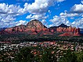 South aspect of Capitol Butte rises above Sedona
 -
 Capitol Butte to left
 -
 East aspect (left)
 -
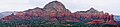 South aspect


References
- ^ a b c d e f "Capitol Butte - 6,355' AZ". listsofjohn.com. Retrieved 2023-11-07.
- ^ a b United States Board on Geographic Names, Decisions on Geographic Names in the United States, Decision List No. 7102, 1971, page 1.
- ^ a b "Capitol Butte". Geographic Names Information System. United States Geological Survey, United States Department of the Interior. Retrieved 2023-11-07.
- ^ a b c "Capitol Butte, Arizona". Peakbagger.com. Retrieved 2023-11-07.
- ^ Bruce Grubbs, Hiking Northern Arizona: A Guide to Northern Arizona's Greatest Hiking Adventures, Rowman & Littlefield, 2021, ISBN 9781493053384, p. 195.
- ^ Will Croft Barnes, Arizona Place Names, University of Arizona Press, 2016, ISBN 9780816534951, p. 76.
- ^ Wayne Ranney, Sedona Through Time: Geology of the Red Rocks, Red Lake Books, 1993, ISBN 9780961167899, p. 83.
- ^ Bruce Grubbs, Best Easy Day Hikes Sedona, Rowman & Littlefield, 2019, ISBN 9781493041169, p. 79.
- ^ Peel, M. C.; Finlayson, B. L.; McMahon, T. A. (2007). "Updated world map of the Köppen−Geiger climate classification". Hydrol. Earth Syst. Sci. 11. ISSN 1027-5606.
External links
Wikimedia Commons has media related to Capitol Butte.
- Weather forecast: Capitol Butte
Places adjacent to Capitol Butte | ||||||||||||||||
|---|---|---|---|---|---|---|---|---|---|---|---|---|---|---|---|---|
| ||||||||||||||||


