Collonges, Ain
Commune in Auvergne-Rhône-Alpes, France
Commune in Auvergne-Rhône-Alpes, France
Collonges Colonges (Arpitan) | ||
|---|---|---|
Commune | ||
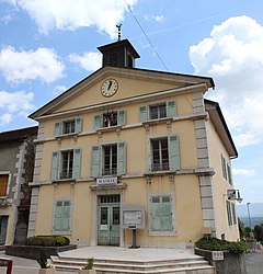 Collonges Town Hall | ||
 Coat of arms | ||
Location of Collonges  | ||
(2020–2026) Lionel Perreal[1] | | |
| Area 1 | 16.25 km2 (6.27 sq mi) | |
| Population (2021)[2] | 2,249 | |
| • Density | 140/km2 (360/sq mi) | |
| Time zone | UTC+01:00 (CET) | |
| • Summer (DST) | UTC+02:00 (CEST) | |
| INSEE/Postal code | 01109 /01550 | |
| Elevation | 329–1,621 m (1,079–5,318 ft) (avg. 500 m or 1,600 ft) | |
| 1 French Land Register data, which excludes lakes, ponds, glaciers > 1 km2 (0.386 sq mi or 247 acres) and river estuaries. | ||
Collonges (French pronunciation: [kɔlɔ̃ʒ]; Arpitan: Colonges) is a commune in the Ain department in the Auvergne-Rhône-Alpes region in Eastern France. Collonges is located on the border with the Haute-Savoie department, just northeast of Fort l'Écluse in Léaz, Ain. It is also situated 20 km (12.4 mi) southwest of Geneva, Switzerland.[3][4]
Demographics
| Year | Pop. | ±% p.a. |
|---|---|---|
| 1968 | 901 | — |
| 1975 | 966 | +1.00% |
| 1982 | 926 | −0.60% |
| 1990 | 1,000 | +0.97% |
| 1999 | 1,106 | +1.13% |
| 2009 | 1,821 | +5.11% |
| 2014 | 2,163 | +3.50% |
| 2020 | 2,230 | +0.51% |
| Source: INSEE[5] | ||
See also
References
- ^ "Répertoire national des élus: les maires" (in French). data.gouv.fr, Plateforme ouverte des données publiques françaises. 13 September 2022. Archived from the original on 28 June 2020. Retrieved 3 May 2024.
- ^ "Populations légales 2021". The National Institute of Statistics and Economic Studies. 28 December 2023.
- ^ Collonges Fort L'Ecluse Archived 2008-09-17 at the Wayback Machine
- ^ Inheritance museums and monuments: Fort l'Ecluse Archived 2008-07-20 at the Wayback Machine
- ^ Population en historique depuis 1968 Archived 19 December 2023 at the Wayback Machine, INSEE
Wikimedia Commons has media related to Collonges, Ain.
- v
- t
- e

- L'Abergement-Clémenciat
- L'Abergement-de-Varey
- Ambérieu-en-Bugey
- Ambérieux-en-Dombes
- Ambléon
- Ambronay
- Ambutrix
- Andert-et-Condon
- Anglefort
- Apremont
- Aranc
- Arandas
- Arbent
- Arbigny
- Arboys en Bugey
- Argis
- Armix
- Ars-sur-Formans
- Artemare
- Arvière-en-Valromey
- Asnières-sur-Saône
- Attignat
- Bâgé-Dommartin
- Bâgé-le-Châtel
- Balan
- Baneins
- Béard-Géovreissiat
- Beaupont
- Beauregard
- Béligneux
- Belleysubpr
- Belleydoux
- Bellignat
- Bénonces
- Bény
- Béréziat
- Bettant
- Bey
- Beynost
- Billiat
- Birieux
- Biziat
- Blyes
- Bohas-Meyriat-Rignat
- La Boisse
- Boissey
- Bolozon
- Bouligneux
- Bourg-en-Bressepref
- Bourg-Saint-Christophe
- Boyeux-Saint-Jérôme
- Boz
- Brégnier-Cordon
- Brénod
- Brens
- Bresse Vallons
- Bressolles
- Brion
- Briord
- Buellas
- La Burbanche
- Ceignes
- Cerdon
- Certines
- Cessy
- Ceyzériat
- Ceyzérieu
- Chalamont
- Chaleins
- Chaley
- Challes-la-Montagne
- Challex
- Champagne-en-Valromey
- Champdor-Corcelles
- Champfromier
- Chanay
- Chaneins
- Chanoz-Châtenay
- La Chapelle-du-Châtelard
- Charix
- Charnoz-sur-Ain
- Château-Gaillard
- Châtenay
- Châtillon-la-Palud
- Châtillon-sur-Chalaronne
- Chavannes-sur-Reyssouze
- Chaveyriat
- Chazey-Bons
- Chazey-sur-Ain
- Cheignieu-la-Balme
- Chevillard
- Chevroux
- Chevry
- Chézery-Forens
- Civrieux
- Cize
- Cleyzieu
- Coligny
- Collonges
- Colomieu
- Conand
- Condamine
- Condeissiat
- Confort
- Confrançon
- Contrevoz
- Conzieu
- Corbonod
- Corlier
- Cormoranche-sur-Saône
- Cormoz
- Corveissiat
- Courmangoux
- Courtes
- Crans
- Cressin-Rochefort
- Crottet
- Crozet
- Cruzilles-lès-Mépillat
- Culoz-Béon
- Curciat-Dongalon
- Curtafond
- Cuzieu
- Dagneux
- Divonne-les-Bains
- Dompierre-sur-Chalaronne
- Dompierre-sur-Veyle
- Domsure
- Dortan
- Douvres
- Drom
- Druillat
- Échallon
- Échenevex
- Évosges
- Faramans
- Fareins
- Farges
- Feillens
- Ferney-Voltaire
- Flaxieu
- Foissiat
- Francheleins
- Frans
- Garnerans
- Genouilleux
- Géovreisset
- Gexsubpr
- Giron
- Gorrevod
- Grand-Corent
- Grièges
- Grilly
- Groissiat
- Groslée-Saint-Benoît
- Guéreins
- Hautecourt-Romanèche
- Haut Valromey
- Illiat
- Injoux-Génissiat
- Innimond
- Izenave
- Izernore
- Izieu
- Jassans-Riottier
- Jasseron
- Jayat
- Journans
- Joyeux
- Jujurieux
- Labalme
- Lagnieu
- Laiz
- Lantenay
- Lapeyrouse
- Lavours
- Léaz
- Lélex
- Lent
- Lescheroux
- Leyment
- Leyssard
- Lhuis
- Lompnas
- Loyettes
- Lurcy
- Magnieu
- Maillat
- Malafretaz
- Mantenay-Montlin
- Manziat
- Marboz
- Marchamp
- Marignieu
- Marlieux
- Marsonnas
- Martignat
- Massieux
- Massignieu-de-Rives
- Matafelon-Granges
- Meillonnas
- Mérignat
- Messimy-sur-Saône
- Meximieux
- Mézériat
- Mijoux
- Mionnay
- Miribel
- Misérieux
- Mogneneins
- Montagnat
- Montagnieu
- Montanges
- Montceaux
- Montcet
- Le Montellier
- Monthieux
- Montluel
- Montmerle-sur-Saône
- Montracol
- Montréal-la-Cluse
- Montrevel-en-Bresse
- Murs-et-Gélignieux
- Nantuasubpr
- Neuville-les-Dames
- Neuville-sur-Ain
- Les Neyrolles
- Neyron
- Niévroz
- Nivigne et Suran
- Nivollet-Montgriffon
- Nurieux-Volognat
- Oncieu
- Ordonnaz
- Ornex
- Outriaz
- Oyonnax
- Ozan
- Parcieux
- Parves-et-Nattages
- Péron
- Péronnas
- Pérouges
- Perrex
- Peyriat
- Peyrieu
- Peyzieux-sur-Saône
- Pirajoux
- Pizay
- Plagne
- Le Plantay
- Plateau d'Hauteville
- Le Poizat-Lalleyriat
- Polliat
- Pollieu
- Poncin
- Pont-d'Ain
- Pont-de-Vaux
- Pont-de-Veyle
- Port
- Pougny
- Pouillat
- Prémeyzel
- Prémillieu
- Prévessin-Moëns
- Priay
- Ramasse
- Rancé
- Relevant
- Replonges
- Revonnas
- Reyrieux
- Reyssouze
- Rignieux-le-Franc
- Romans
- Rossillon
- Ruffieu
- Saint-Alban
- Saint-André-de-Bâgé
- Saint-André-de-Corcy
- Saint-André-d'Huiriat
- Saint-André-le-Bouchoux
- Saint-André-sur-Vieux-Jonc
- Saint-Bénigne
- Saint-Bernard
- Saint-Cyr-sur-Menthon
- Saint-Denis-en-Bugey
- Saint-Denis-lès-Bourg
- Saint-Didier-d'Aussiat
- Saint-Didier-de-Formans
- Saint-Didier-sur-Chalaronne
- Sainte-Croix
- Sainte-Euphémie
- Sainte-Julie
- Saint-Éloi
- Sainte-Olive
- Saint-Étienne-du-Bois
- Saint-Étienne-sur-Chalaronne
- Saint-Étienne-sur-Reyssouze
- Saint-Genis-Pouilly
- Saint-Genis-sur-Menthon
- Saint-Georges-sur-Renon
- Saint-Germain-de-Joux
- Saint-Germain-les-Paroisses
- Saint-Germain-sur-Renon
- Saint-Jean-de-Gonville
- Saint-Jean-de-Niost
- Saint-Jean-de-Thurigneux
- Saint-Jean-le-Vieux
- Saint-Jean-sur-Reyssouze
- Saint-Jean-sur-Veyle
- Saint-Julien-sur-Reyssouze
- Saint-Julien-sur-Veyle
- Saint-Just
- Saint-Laurent-sur-Saône
- Saint-Marcel
- Saint-Martin-de-Bavel
- Saint-Martin-du-Frêne
- Saint-Martin-du-Mont
- Saint-Martin-le-Châtel
- Saint-Maurice-de-Beynost
- Saint-Maurice-de-Gourdans
- Saint-Maurice-de-Rémens
- Saint-Nizier-le-Bouchoux
- Saint-Nizier-le-Désert
- Saint-Paul-de-Varax
- Saint-Rambert-en-Bugey
- Saint-Rémy
- Saint-Sorlin-en-Bugey
- Saint-Sulpice
- Saint-Trivier-de-Courtes
- Saint-Trivier-sur-Moignans
- Saint-Vulbas
- Salavre
- Samognat
- Sandrans
- Sault-Brénaz
- Sauverny
- Savigneux
- Ségny
- Seillonnaz
- Sergy
- Sermoyer
- Serrières-de-Briord
- Serrières-sur-Ain
- Servas
- Servignat
- Seyssel
- Simandre-sur-Suran
- Sonthonnax-la-Montagne
- Souclin
- Sulignat
- Surjoux-Lhopital
- Talissieu
- Tenay
- Thil
- Thoiry
- Thoissey
- Torcieu
- Tossiat
- Toussieux
- Tramoyes
- La Tranclière
- Trévoux
- Valeins
- Val-Revermont
- Valromey-sur-Séran
- Valserhône
- Vandeins
- Varambon
- Vaux-en-Bugey
- Verjon
- Vernoux
- Versailleux
- Versonnex
- Vesancy
- Vescours
- Vésines
- Vieu-d'Izenave
- Villars-les-Dombes
- Villebois
- Villemotier
- Villeneuve
- Villereversure
- Villes
- Villette-sur-Ain
- Villieu-Loyes-Mollon
- Viriat
- Virieu-le-Grand
- Virignin
- Vongnes
- Vonnas
- pref: prefecture
- subpr: subprefecture
Authority control databases | |
|---|---|
| International |
|
| National |
|


