Hurricane Katrina's winds and storm surge reached the Mississippi coastline on the morning of August 29, 2005.[1][2] beginning a two-day path of destruction through central Mississippi; by 10a.m. CDT on August 29, 2005, the eye of Katrina began traveling up the entire state, only slowing from hurricane-force winds at Meridian near 7p.m. and entering Tennessee as a tropical storm.[3] Many coastal towns of Mississippi (and Louisiana) had already been obliterated, in a single night.[4] Hurricane-force winds reached coastal Mississippi by 2a.m.[1] and lasted over 17 hours, spawning 11 tornadoes (51 in other states[2]) and a 28-foot (8.5 m) storm surge[2] flooding 6–12 miles (9.7–19.3 km) inland. Many, unable to evacuate,[5] survived by climbing to attics or rooftops, or swimming to higher buildings and trees. The worst property damage from Katrina occurred in coastal Mississippi, where all towns flooded over 90% in hours, and waves destroyed many historic buildings, with others gutted to the 3rd story. Afterward, 238 people died in Mississippi, and all counties in Mississippi were declared disaster areas, 49 for full federal assistance.[6][7] Regulations were changed later for emergency centers and casinos. The emergency command centers were moved higher because all 3 coastal centers flooded at 30 ft (9.1 m) above sea level. Casinos were allowed on land rather than limited to floating casino barges as in 2005.
More than one million people in Mississippi were affected, and almost 6 months later, the extent of the devastation in Mississippi was still described as "staggering" in USA Today on February 16, 2006:[8] "The Mississippi Gulf Coast has been devastated. The extent of the devastation in Mississippi is also staggering. Since Katrina hit, more than half a million people in Mississippi have applied for assistance from FEMA. In a state of just 2.9 million residents, that means more than one in six Mississippians have sought help.
Scattered damage
General: The effects of a hurricane can be scattered across a large area, because hurricanes are large complex storms which spawn smaller thunderstorms, tornadoes, storm surges, and sea waves. Wind speeds east of the eye can be 40–50 mph (64–80 km/h) higher than winds west of the eye. Wind gusts can be scattered, so boats or debris can ram one house but not another. One building can seem untouched, while others nearby are flattened; also trees can be partly weakened: tree limbs can fall months later, crashing onto a roof, automobile, fence, etc.
Specific: Because Hurricane Katrina became a massive storm,[3][9] over 450 miles (720 km) wide, not only the eyewall-path, and 28-foot (8.5 m) storm surge, but also the outer bands of the hurricane arms caused scattered damage hundreds of miles away from the center. Eleven (11) spawned tornadoes were recorded in Mississippi (51 elsewhere).[2] It is possible that scattered damage to northern Mississippi occurred, by spin-off storms, around the time Katrina made landfall in eastern Greater New Orleans (Louisiana's "boot toe") and then, again, near Bay St. Louis, Mississippi, heading north-northeast into central Mississippi, at 10a.m. on August 29.[3] Note that "landfall" occurred over towns submerged under 20 feet (6 m) of water. As buildings collapsed, water-tight appliances floated, sending refrigerators and dishwashers to ram other buildings and block streets.[9] Millions of homes and buildings were affected, along with ships, boats, and more than 40 offshore oil rigs.
Roadways and railways were put out of service by excessive amounts of debris and occasional collapse (most notably the I-10 Twin Span Bridge). Costs of debris removal in the Gulf Coast region is estimated at $200 million. Until major roadways (US 49, US 59) could be cleared, deliverers of supplies and other emergency relief were forced to detour through highway 609 or highway 43/603, though these routes were not officially posted.[10]
Impact synopsis
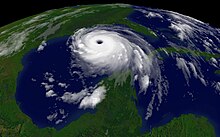
Damage to Long Beach, Mississippi following Hurricane KatrinaFigure KW10: Katrina Wind speed at 10 a.m. CDT, August 29, 2005: hurricane eye (central blue hub) a few miles to the west of Waveland, Mississippi.
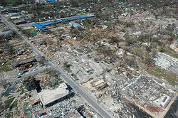
The Gulf Coast of Mississippi suffered near total devastation[1][11][12] from Hurricane Katrina on August 29, with hurricane winds, 28-foot (8.5 m) storm surge, and 55-foot (17 m) sea waves[13] pushing casino barges, boats and debris into towns, and leaving 236 people dead, 67 missing, and billions of dollars in damages.[14] Katrina made landfall below central Mississippi, 30 miles (48 km) east of New Orleans at 6:10 a.m.,[3] the storm's powerful, right, front quadrant covered coastal Mississippi and southern Alabama, increasing wind and flood damage. After making initial landfall in Louisiana, four hours later Katrina made another landfall north at the state line (near the mouth of the Pearl River)[3] and passed over submerged towns around Bay St. Louis as a Category 3 hurricane with winds over 120 mph (190 km/h) and 28-foot (8.5 m) surge.[13] Battered by wind, rain and storm surges, some beachfront neighborhoods were leveled entirely, with flooding 6–12 miles (9.7–19.3 km) inland, crossing Interstate-10 (I-10) in some places.[15]
Winds reached hurricane-force in Hancock and Harrison County[1] by 2a.m.,[16] and winds intensified. As Katrina passed 30 miles (48 km) east of central New Orleans, with 57 mph (92 km/h) winds, by 10a.m., landfall in Mississippi increased hurricane-force winds in an area of 600,000 Mississippi residents, covering several counties (see Figure KW10: Katrina Wind Speed map): Hancock, Harrison, Jackson County, Pearl River County, Stone, Walthall, Marion, Lamar County, Forrest County, and Perry County (see Map of Counties). Other counties to see a strong hurricane force impact of Katrina were Covington County, Jefferson Davis County, Simpson County, Smith County, Hinds County, Rankin County, and Scott County. Katrina maintained a high wind capacity of 80–85 mph in cities like Mendenhall, Magee, Jackson, Brandon, and Forest in Mississippi. Those cities contained much tree damage, roof and patio damage, power line damage, and much thrown debris. In Jackson, streets were cleared off due to the intense strong winds and rains that carried throughout the entire day. During this 10a.m. timeframe, hurricane-force winds continued over the barrier islands and Louisiana peninsula nearby; however, for the remainder of Louisiana, the winds were subsiding into gale-force winds after 10a.m. when Katrina was becoming primarily a Mississippi hurricane.[17]
Map of Mississippi Counties, noting flood/severe damage areas (yellow shaded counties).
Several casinos, which were floated on barges to comply with Mississippi land-based gambling laws, were washed hundreds of yards inland by waves.[18] According to MSNBC, a 28-foot (8.5 m) storm surge came ashore wiping out 90% of the buildings along the Biloxi-Gulfport coastline. A number of streets and bridges were washed away, including the bridge sections of U.S. Highway 90. In particular, the roadway portion of the U.S. Highway 90 bridge between Bay St. Louis and Pass Christian was completely destroyed by the storm; only the support structure was left.
The three counties most affected by the storm were Hancock County, Harrison County, and Jackson County, although almost all counties had damage, and 47 counties were declared full disaster areas. Mississippi Emergency Management Agency (MEMA) officials also recorded deaths in Hinds, Warren, and Leake counties. About 800,000 people through the state experienced power outages, which is almost a third of the population.[19]
The three coastal counties of Mississippi, populated by about 400,000 people (almost the population of central New Orleans), had been mostly evacuated before Katrina flooded the 100-mile (160 km) region. Katrina's storm surge was the most extensive, as well as the highest, in the documented history of the United States; large portions of Hancock County, Harrison County,[1] and Jackson County were inundated by the storm surge, affecting most of the populated areas.[20] Surge covered almost the entire lower half of Hancock County, destroying the coastal communities of Clermont Harbor and Waveland, and much of Bay St. Louis, and flowed up the Jourdan River, flooding Kiln. In Harrison County, Pass Christian was completely inundated, along with a narrow strip of land to the east along the coast, which includes the cities of Long Beach and Gulfport; the flooding was more extensive in communities such as D'Iberville, which borders the Back Bay of Biloxi. Biloxi, on a peninsula between the Back Bay and the coast, was particularly hard hit, especially the low-lying Point Cadet area.
In Jackson County, storm surge flowed up the wide river estuary, with the combined surge and freshwater floods cutting the county in half. Over 90% of Pascagoula, the easternmost coastal city in Mississippi, was flooded from surge. Other Jackson County communities such as Porteaux Bay were destroyed, and St. Martin was hard hit, along with Ocean Springs, Moss Point, Gautier, and Escatawpa.
Surveying the damage the day after Katrina's passing, Mississippi governor Haley Barbour called the scene indescribable, saying "I can only imagine that this is what Hiroshima looked like 60 years ago."[21] The mayor of Biloxi, A.J. Holloway, told the Biloxi Sun Herald, "This is our tsunami."[22] Relief and rebuilding efforts initially focused on restoring power and clearing communities of debris up to eight feet (2.4 m) in depth.[23]
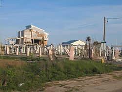
Many historic buildings were destroyed in Mississippi, including the cottages and second-story porches around the Beauvoir mansion, home of Jefferson Davis. Hundreds of irreplaceable Civil War-era artifacts from the Jefferson Davis home and museum were either lost or destroyed.
The lower three floors of many high-rise casinos and hotels were gutted. (See details below).
Along with countless others affected by the hurricane, U.S. senator Trent Lott lost his Pascagoula home, and the boyhood home of Green Bay Packers quarterback Brett Favre was also totally destroyed.
Psychological impact
Both the Mississippi residents who survived the hurricanes as well as the disaster relief workers who supported them are at high risk of developing Post-Traumatic Stress Disorder, or PTSD, a mental health disorder that can develop after exposure to an extreme situation such as warfare, a natural disaster or abuse.[24]
Although Hurricane Katrina later travelled mainly through Mississippi, it began as a Category 1 hurricane on August 25, crossing the southern tip of Florida (raining 14 inches (360 mm) [36 cm][3]) into the Gulf, where it weakened, then strengthened into a massive Category 5 with 175 mph (282 km/h) sustained winds. Slowly turning north along the eastern coast of Louisiana, at 4a.m. August 29, sustained winds were 132 mph (212 km/h), 90 miles (140 km) SSE of New Orleans.[3] As Katrina came ashore near Buras, LA at 6:10 CDT, with reported 125 mph (201 km/h) winds (Category 3),[3] it passed 40 miles (64 km) east[25] of New Orleans and headed to the Mississippi state line (mouth of Pearl River, 10a.m. CDT),[26] with hurricane-force winds travelling up central Mississippi until weakening at Meridian,[27] and entering Tennessee as a tropical storm. Despite the hurricane force centered on Mississippi, neighboring areas were also affected: when New Orleans began slowly flooding with high east/north winds, a 28-foot (8.5 m) storm surge eastward from Bay St. Louis devastated coastal areas with 30–55 feet (9.1–16.8 m) sea waves,[28] flooding 12 miles (19 km) inland. The waves pushed barges, oil rigs, ships, and debris into submerged towns to flatten many coastal buildings across to Pascagoula with 20-foot (6.1 m) surge,[28] and into Alabama with 15-foot (4.6 m) surge[28] and 24-foot (7.3 m) waves battering beach houses inside Mobile Bay and tilting the battleship USS Alabama. (See extensive details below).
Mississippi evacuation
By 4:30 a.m. CDT, on August 29, 2005, just hours before Hurricane Katrina landfall, many shelters in Mississippi were full to capacity, including many Red Cross shelters, the Jackson Coliseum (which allowed pets), and five special-needs shelters. The shelters had filled within 24 hours of opening.
Days earlier, on August 25, when Hurricane Katrina crossed the southern tip of Florida, government offices in Mississippi had already discussed emergency evacuation plans for days. On August 26, the Mississippi National Guard was activated, raising the level of concern, and on August 27, the state government activated its Emergency Operations Center, and local governments began issuing evacuation orders: the Mississippi Emergency Management Agency (MEMA)[29] advised not opening shelters in coastal counties. However, on August 28, the Red Cross also opened shelters in coastal counties, and by 7:00 p.m., 11 counties and eleven cities issued evacuation orders, a number which increased to 41 counties and 61 cities before the following morning, when Katrina came ashore. Moreover, 57 emergency shelters were established on coastal communities, with 31 additional shelters available to open if needed....[30]
Since the evacuation was not total, many people survived the 30-foot (9.1 m) storm tide by climbing into the second-floor attic, or knocking out walls and ceiling boards to climb onto the roof or nearby trees.[31] Tree trunks remained standing,[32] even near the beaches, where many houses were leveled. Other people had swum to taller buildings or trees.[33] Over 100 people were rescued from roof tops and trees in Mississippi.
Although the population of the three (3) coastal counties had been nearly 400,000, and the storm tide was 20–30 feet (6.1–9.1 m) with coastal winds 75–120 mph (121–193 km/h), fewer than 250 people died in Mississippi during Hurricane Katrina.
Federal buildings/projects
Because of federal intent to rebuild or recover projects of the US Federal Government, the damage assessment to federal buildings in Mississippi covers actual costs: the amount needed to resume operations at market costs. The following federal projects are described in terms of damage, along with the cost to resume operations:[7]
$1.987 billion: as requested by President George W. Bush, for Navy Shipbuilding and Conversion; these funds will assist Northrop Grumman to "replace destroyed or damaged equipment, prepare and recover naval vessels under contract; and provide for cost adjustments." Ships were damaged in Pascagoula.
(unknown): as increased funding for USDA housing programs which provide subsidized loans and housing repair funding.
$75 million: in wildlife habitat restoration, for the Corps of Engineers to enhance estuarine habitats in Mississippi: following the Governor's proposal regarding oyster reef and coastal marsh restoration. The Mississippi Department of Marine Resources will assist the Corps as these projects develop.
$75 million: for the Corps of Engineers on various coastal projects: to accelerate completion of authorized projects along the Mississippi Gulf Coast.
$1.1 billion: to repair vital federal facilities in Mississippi, including:
$292.5 million for the repair and renovation of the VA hospital in Biloxi.
$45 million for the Armed Forces Retirement Home in Gulfport.
The cost amounts were decided for work continuing in 2006. Note that repairs include modern renovation, since it is not feasible to assess damage in terms of restoring federal buildings to the year they were built. However, the costs provide a condensed measure of the construction damage, without counting the millions of lost roof tiles, thousands of broken windows, etc.
Katrina's 28-foot (8.5 m) storm surge, and 55-foot (17 m) sea waves,[13] practically obliterated Waveland, Mississippi, and state officials said that it took a harder hit from the wind and water than any other town along the coast. Katrina came ashore during the high tide of 8:01am,[34] raising the storm tide by 2 ft (0.61 m), to over 30 feet (9.1 m). The storm dragged away almost every structure within one half mile of the beach, leaving driveways and walkways that went to nowhere.[33] The death toll was estimated at 50.
In Bay St. Louis, Mississippi, a foot (30 cm) of water swamped the Emergency Operations Center at the Hancock County courthouse, which sits 30 feet (9.1 m) above sea level.[35] Katrina also destroyed the first floor and dormitories of Saint Stanislaus College.[citation needed]
The destruction brought forth by Katrina also caused about one-quarter of the labor force to lose their jobs, with the unemployment rate reaching as high as 24.3%.[36]
Harrison County
Damage to the Biloxi-Ocean Springs bridge.Damage to the riverboat Palace Casino located in Biloxi, Mississippi (MS), resulting from Hurricane Katrina.
Harrison County, Mississippi was hit particularly hard by the hurricane and the storm surge. Its two largest coastal cities, Biloxi and Gulfport, suffered severe damages and a number of casualties. By September 126 people were already confirmed dead.[37] Smaller coastal towns were also severely damaged. Much of Long Beach and most of Pass Christian, which bore the brunt of Category 5 Hurricane Camille in 1969, were leveled. Nearby Gulfshore Baptist Assembly, a camp owned and operated by the Mississippi Baptist Convention, has been permanently closed, and recommendations have been made to build a new facility elsewhere.[38]
In the tourist town of Biloxi, widespread damage was reported as several of the city's attractions were destroyed. The lower 3 floors of many high-rise casino-hotels were gutted, as in the former Grand Casino of Gulfport, or the Imperial Palace (IP Hotel and Casino) or Beau Rivage in Biloxi.[39] Many restaurants were destroyed and several casino barges had been washed out of the water and onto land. Residents who survived Hurricane Camille stated that Katrina was "much worse," with a storm surge reportedly reaching further inland than the previous catastrophic storm. Katrina's wind estimates were lighter than Camille's, and the central air pressure was slightly higher, but Camille was also a much smaller storm so the greater impact of the storm surge may be due to the size. Keesler Air Force Base, also located in Biloxi, reported extensive damage to its facilities. Gulfport authorities reported to news station CNN that up to ten feet of water covered downtown streets. The Biloxi-Ocean Springs Bridge was also totally destroyed, and US 90 had heavy debris and severe damage to the roadbed.
Thirty of the confirmed deaths in Harrison County were at the St. Charles apartment complex, said Kelly Jakubic with the county's Emergency Operations Center.[40] The apartment complex was reported, by local news sources, to have collapsed with dozens of residents inside. FOX News also reported deaths at the Quiet Water Beach apartments.[22] (A later investigation by Biloxi's WLOX could not confirm any deaths at these apartments.[41])
Rebuilding in Harrison County proceeded at different paces in different towns. The town of Biloxi was greatly helped by the resurgence of the casino industry, while smaller towns such as Pass Christian did not have an economic base with which to start the reconstruction effort. By January 2007, almost a year and a half after the Hurricane, Pass Christian had still not yet begun rebuilding its city buildings, and volunteer labor was still involved in rebuilding private homes in the town.[42]
In Jackson County, the storm surge flowed up the wide river estuary, with the combined surge and freshwater floods cutting the county in half. Over 90% of Pascagoula, the easternmost coastal city in Mississippi, and 75 miles (121 km) east of Katrina's landfall, was flooded from surge. Other Jackson County communities such as Porteaux Bay and Gulf Hills were destroyed, and St. Martin was hard hit; Ocean Springs, Moss Point, Gautier, and Escatawpa also suffered major surge damage.
Katrina disaster area: 49 counties for full Federal assistance (yellow shading).
After Hurricane Katrina, all counties in Mississippi were declared disaster areas, with 49 counties eligible for full Federal assistance. The following Mississippi counties (alphabetical order) reported deaths, tornadoes, or damage:[citation needed]
The names of the 49 counties in Mississippi, declared disaster areas for full Federal assistance, are:[6][43] Adams, Amite, Attala, Claiborne, Choctaw, Clarke, Copiah, Covington, Franklin, Forrest, George, Greene, Hancock, Harrison, Hinds, Holmes, Humphreys, Jackson, Jasper, Jefferson, Jefferson Davis, Jones, Kemper, Lamar, Lauderdale, Lawrence, Leake, Lincoln, Lowndes, Madison, Marion, Neshoba, Newton, Noxubee, Oktibbeha, Pearl River, Perry, Pike, Rankin, Scott, Simpson, Smith, Stone, Walthall, Warren, Wayne, Wilkinson, Winston and Yazoo.[43] Taxpayers were eligible for automatic relief in the 49 Mississippi counties designated for individual assistance.[43]
Other counties were affected as well.
In the region
Since Hurricane Katrina traveled up the entire state, Mississippi lies in the center of the disaster areas for the region. Outside the area of high winds and storm surge, other areas were affected by spin-off tornadoes and rainfall flooding. The map below shows the declared disaster areas in the region.
Disaster areas map: dark orange indicates full assistance, light yellow-orange for Public assistance, or green for Public assistance category A/B.
The south tip of Florida includes damage when Hurricane Katrina originated in the Caribbean Sea, dumping over 14 inches (360 mm) of rain in the area.
Long-term impact
Rebuilding of towns took years, and some areas were not restored. The bay bridges were rebuilt taller and stronger, as had been done around Pensacola in the years following Hurricane Ivan (2004). Because all 3 Emergency Command Centers in the Mississippi coastal counties had been flooded over 30 feet (9.1 m) above sea level,[3] the rules for command-center elevation were changed to relocate to even higher ground. The casino-gambling regulations were changed to allow casinos to be built on land in taller buildings, no longer forcing the use of massive floating casino barges near a city, which could again become battering rams along 2nd and 3rd-story levels of nearby hotels.[citation needed] Many local Gulf Coast water systems were destroyed in the storm. The state government opted to have them reconstructed as a handful of regional water systems and one large regional sewage system.[44]
Celebrities who had previously visited New Orleans came to understand the massive devastation that occurred along the Gulf Coast cities. The US Army Corps of Engineers developed plans to rebuild the protective barrier islands that had been washed out to sea along the coastal areas. Detailed reports were written describing how people had survived by swimming to taller buildings or trees, and noting that those too old or unable to swim did not survive. Many residents moved away and never returned. Medical studies attempted to estimate the indirect deaths caused by people losing their homes or local medical support.
^ abcde Gary Tuchman, Transcript of "Anderson Cooper 361 Degrees" (2006-08-29) 19:00 ET, CNN, CNN.com, web: CNN-ACooper082906: GARY TUCHMAN, CNN Correspondent: Responds to Anderson Cooper that it felt like it would never end, saying winds were at least 100 miles per hour in Gulfport for seven hours, between about 7:00 a.m. and 2:01 p.m. For another five or six hours, on each side of that, they [Gulfport] had hurricane-force winds over 75 miles per hour; much of the city [Gulfport, Mississippi, in Harrison County] of 71,000 was then under water.
^ abcdUS Department of Commerce, "Service Assessment: Hurricane Katrina August 23–31, 2005" (June 2006), pp. 10/16, NOAA’s National Weather Service, Silver Spring, MD, web: NWS-Katrina-PDF Archived 2006-07-23 at the Wayback Machine: page 7 (storm surge 26–28 ft), p. 50: "Appendix C: Tornado Reports Associated with Hurricane Katrina" (62 tornadoes).
^ abcdefghi "Tropical Cyclone Report, Hurricane Katrina." (post-analysis) National Hurricane Center. revised August 10, 2006.
^ As flood waters rose, many streets became swamped and impassable. Emergency crews rescued over 100 people, from rooftops or trees, in Mississippi.
^ ab"FEMA-1604-DR Mississippi Disaster Declaration as of 10/27/2005" (map), FEMA, ITS Mapping and Analysis Center, Washington, DC, 2005-10-27, webpage: FEMA-1604-pdf Archived 2005-09-23 at the Wayback Machine.
^ ab"Information Relating to the Federal Appropriations for Katrina Recovery" (January 6, 2006), Office of the Governor, Mississippi, webpage: "Mississippi Governor Haley Barbour" GBarbour-Rec "Information". Archived from the original on 2007-09-28. Retrieved 2006-08-29..
^ "SIX MONTHS AFTER KATRINA: AN OVERVIEW" (short summary), Office of the House Democratic Leader Nancy Pelosi, February 28, 2006, file: HouseGov-Katrina6.
^ ab Rob Marciano (CNN Meteorologist), Transcript of "Anderson Cooper 360 Degrees" (2006-08-29) 19:00 ET, CNN, CNN.com web: CNN-ACooper082906: "ROB MARCIANO, CNN Meteorologist: Responds to Anderson Cooper that the governor preferred that folks did not go out on the streets because the "streets are literally littered with kitchen appliances."
^Reginald DesRoches, PhD, ed. (2012). Hurricane Katrina: Performance of Transportation Systems. Reston, VA: ASCE, TCLEE. ISBN 9780784408797. Archived from the original on 2014-03-03.
^ "National Weather Service Forecast Office - Mobile/Pensacola" (July 7, 2006), NOAA, webpage: NOAA-KatMob: noted "pure devastation" in MS.
^ More than 100 reports used the term "pure devastation" about Mississippi.
^ abc "Tropical Cyclone Report, Hurricane Katrina." (post-analysis), page 9, National Hurricane Center. revised August 10, 2006.
^Staff writer, "Mississippi's Invisible Coast Archived 2006-01-05 at the Wayback Machine." Sun Herald. December 14, 2005.
^ CNN (Miles O'Brien, Anderson Cooper and Kathleen Koch), "Katrina kills 50 in one Mississippi county" (2006-08-30), CNN News, CNN.com web: CNN-Katrina50.
^Mark Proulx, "Dane’s Story – Part 1 - GCN Feature" (2006-06-03), Gulf Coast News, GulfCoastNews.com web: GCN-DanesStory Archived 2006-10-29 at the Wayback Machine: times of winds/surge.
^Note in Figure KW10: Katrina Wind Speed map, the Louisiana winds subsided (yellow/green) remaining hurricane-force mainly at the peninsula south of the eyewall.
^"WLOX-TV and WLOX.com - Building South Mississippi Together |Rumor Sometimes Becomes National News". Archived from the original on 2006-12-01. Retrieved 2007-09-26.
^ Gates, Jimmie E. "Power to be restored - but not all at once." The Clarion-Ledger. August 30, 2005.
^Staff writer, "What Hiroshima Looked Like Archived 2005-09-07 at the Wayback Machine." [news24.com]. February 9, 2006.
^ ab FOX News reporters, "'This Is Our Tsunami'" (2005-08-30), FOX News, FOXNews.com web: FOX-HK-tsunami.
^ Korosec, Thomas, "Small town in eye of storm wiped out," Houston Chronicle, August 31, 2005.
^Warneka, T. Healing Katrina: Volunteering in Post-Hurricane Mississippi. Archived 2008-05-16 at the Wayback Machine Asogomi Publishing International. Archived 2017-10-06 at the Wayback Machine
^ New Orleans was 40 miles (64 km) from the eye path connecting Buras to the Pearl River.
^ "Hurricane KATRINA." (6am advisory) National Hurricane Center. August 29, 2005.
^ "Tropical Summary Message" (NOAA report), Hydrometeorological Prediction Center, August 31, 2005, webpage: TCpat2.
^ abc "National Weather Service Forecast Office - Mobile/Pensacola," NOAA, July 7, 2006, webpage: NOAA-Mob-Katrina.
^United States Congress (February 19, 2006). A Failure of Initiative: Final Report of the Select Bipartisan Committee to Investigate the Preparation for and Response to Hurricane Katrina(PDF). Washington, DC: Government Printing Office. pp. 60–61. Archived from the original (PDF) on March 26, 2009. Retrieved 2006-04-10.
^Unlike some suburbs, many towns in Mississippi had numerous strong trees, such as old oak trees, higher than roof-tops.
^The tree trunks, after losing small branches, were narrow compared to wide walls battered by waves, boats and debris.
^ abBurdeau, Cain. "Waveland practically wiped off map by force of Katrina Archived 2006-05-04 at the Wayback Machine." WWL-TV. August 31, 2005.
^ Associated Press, "Katrina at a Glance" (August 31, 2005), page 4A, Mobile Register, web: MobileRegister-083105-PDF Archived 2008-10-01 at the Wayback Machine.
^Staff Writer. "Miss. unemployment dips slightly." The Clarion-Ledger. November 24, 2005.
^Korosec, Thomas. "126 dead; gas, hot meals in short supply." Houston Chronicle. September 1, 2005.
^Perkins, William H., Jr (November 9, 2006). "Messengers approve record CP budget." The Baptist Record130 (44): 1, 5. ISSN 0005-5778
^Note: see Beau Rivage about 3rd-floor damage to high-rise buildings.
^Treaster, Joseph B.; Zernike, Kate. "Hurricane Katrina Slams Into Gulf Coast; Dozens Are Dead." The New York Times. August 30, 2005.
^Philips, Steve. "Rumor Sometimes Becomes National News Archived 2012-07-22 at the Wayback Machine." WLOX. August 26, 2006.
^The town of Pass Christian was still actively recruiting volunteers to help rebuild and clean up the city through its website "Rebuild the Pass Archived 2009-09-09 at the Wayback Machine"
^ abc "Hurricane Katrina Disaster Area" (description, lists), TaxAlmanac, 2005-12-08, webpage: TAcounties: contains lists of disaster area counties in each state.
^Pender, Geoff (September 15, 2022). "State, business leaders consider regionalization of Jackson water system. Local officials hate the idea". Mississippi Today. Nonprofit Mississippi News. Retrieved February 12, 2023.
Further reading
Ellis Anderson (2010). Under Surge, Under Siege: The Odyssey of Bay St. Louis and Katrina. Univ. Press of Mississippi. ISBN 978-1-60473-503-1.
External links
Wikimedia Commons has media related to Hurricane Katrina aftermath in Mississippi.
Katrina, One Year Later: Three Perspectives Photos of the Mississippi Gulf Coast by David Wharton, Bruce West and Todd Bertolaet.
Aftermath of Katrina on the Mississippi Gulf Coast (Photo Essay)
December 2005 issue of MS Economic Review and Outlook
Interviews about Katrina with Mississippi community activists
Healing Katrina: Volunteering in Post-Hurricane Mississippi


 Extratropical cyclone, remnant low, tropical disturbance, or monsoon depression