Entrammes
Commune in Pays de la Loire, France

Coat of arms
Location of Entrammes

(2020–2026) Jérôme Allaire[1]
1
(2021)[2]
53094 /53260
(avg. 50 m or 160 ft)
Entrammes (French pronunciation: [ɑ̃tʁam]) is a commune in the Mayenne department in north-western France. It is located about 3.7 kilometres (2.3 mi) west of Parné-sur-Roc and about 3.7 kilometres (2.3 mi) south of Laval Entrammes Airport in Laval.[3]
History
Entrammes owes its location to a major ford across the rivers Mayenne and Jouanne: the road connecting Le Mans to Rennes traditionally crossed the river here. Consequently, a substantial town covering approximately 55 hectares existed here already two thousand years ago, and was already settled during the first century BC.
Population
| Year | Pop. | ±% p.a. |
|---|---|---|
| 1968 | 1,019 | — |
| 1975 | 1,183 | +2.15% |
| 1982 | 1,582 | +4.24% |
| 1990 | 1,802 | +1.64% |
| 1999 | 1,847 | +0.27% |
| 2007 | 2,108 | +1.67% |
| 2012 | 2,237 | +1.20% |
| 2017 | 2,256 | +0.17% |
| Source: INSEE[4] | ||
Gallery
-
 The old Town Hall
 -
 The Port-du-Salut Abbey
 -
 The Roman-Gaul Baths
 -
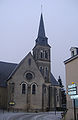 The parish church


See also
References
- ^ "Répertoire national des élus: les maires" (in French). data.gouv.fr, Plateforme ouverte des données publiques françaises. 13 September 2022.
- ^ "Populations légales 2021". The National Institute of Statistics and Economic Studies. 28 December 2023.
- ^ Maps, Weather, and Airports for Entrammes, France, retrieved 5 April 2010
- ^ Population en historique depuis 1968, INSEE
Wikimedia Commons has media related to Entrammes.
- v
- t
- e
 Communes of the Mayenne department
- Ahuillé
- Alexain
- Ambrières-les-Vallées
- Andouillé
- Argentré
- Aron
- Arquenay
- Assé-le-Bérenger
- Astillé
- Athée
- Averton
- La Baconnière
- Bais
- Ballots
- Bannes
- La Bazoge-Montpinçon
- La Bazouge-de-Chemeré
- La Bazouge-des-Alleux
- Bazougers
- Beaulieu-sur-Oudon
- Beaumont-Pied-de-Bœuf
- Belgeard
- Bierné-les-Villages
- Le Bignon-du-Maine
- La Bigottière
- Blandouet-Saint Jean
- La Boissière
- Bonchamp-lès-Laval
- Bouchamps-lès-Craon
- Bouère
- Bouessay
- Boulay-les-Ifs
- Le Bourgneuf-la-Forêt
- Bourgon
- Brains-sur-les-Marches
- Brecé
- Brée
- La Brûlatte
- Le Buret
- Carelles
- Chailland
- Châlons-du-Maine
- Champéon
- Champfrémont
- Champgenéteux
- Changé
- Chantrigné
- La Chapelle-Anthenaise
- La Chapelle-au-Riboul
- La Chapelle-Craonnaise
- La Chapelle-Rainsouin
- Charchigné
- Château-Gontier-sur-Mayennesubpr
- Châtelain
- Châtillon-sur-Colmont
- Chemazé
- Chémeré-le-Roi
- Chérancé
- Chevaigné-du-Maine
- Colombiers-du-Plessis
- Commer
- Congrier
- Contest
- Cosmes
- Cossé-en-Champagne
- Cossé-le-Vivien
- Coudray
- Couesmes-Vaucé
- Couptrain
- Courbeveille
- Courcité
- Craon
- Crennes-sur-Fraubée
- La Croixille
- La Cropte
- Cuillé
- Daon
- Denazé
- Désertines
- La Dorée
- Entrammes
- Ernée
- Évron
- Fontaine-Couverte
- Forcé
- Fougerolles-du-Plessis
- Fromentières
- Gastines
- Le Genest-Saint-Isle
- Gennes-Longuefuye
- Gesnes
- Gesvres
- Gorron
- La Gravelle
- Grazay
- Grez-en-Bouère
- La Haie-Traversaine
- Le Ham
- Hambers
- Hardanges
- Hercé
- Le Horps
- Houssay
- Le Housseau-Brétignolles
- L'Huisserie
- Izé
- Javron-les-Chapelles
- Jublains
- Juvigné
- Landivy
- Larchamp
- Lassay-les-Châteaux
- Laubrières
- Launay-Villiers
- Lavalpref
- Lesbois
- Levaré
- Lignières-Orgères
- Livet
- Livré-la-Touche
- Loiron-Ruillé
- Loupfougères
- Louverné
- Louvigné
- Madré
- Maisoncelles-du-Maine
- Marcillé-la-Ville
- Marigné-Peuton
- Martigné-sur-Mayenne
- Mayennesubpr
- Mée
- Ménil
- Méral
- Meslay-du-Maine
- Mézangers
- Montaudin
- Montenay
- Montflours
- Montigné-le-Brillant
- Montjean
- Montreuil-Poulay
- Montsûrs
- Moulay
- Neau
- Neuilly-le-Vendin
- Niafles
- Nuillé-sur-Vicoin
- Oisseau
- Olivet
- Origné
- La Pallu
- Parigné-sur-Braye
- Parné-sur-Roc
- Le Pas
- La Pellerine
- Peuton
- Placé
- Pommerieux
- Pontmain
- Port-Brillet
- Préaux
- Prée-d'Anjou
- Pré-en-Pail-Saint-Samson
- Quelaines-Saint-Gault
- Ravigny
- Renazé
- Rennes-en-Grenouilles
- Le Ribay
- La Roche-Neuville
- La Roë
- La Rouaudière
- Ruillé-Froid-Fonds
- Sacé
- Saint-Aignan-de-Couptrain
- Saint-Aignan-sur-Roë
- Saint-Aubin-du-Désert
- Saint-Aubin-Fosse-Louvain
- Saint-Baudelle
- Saint-Berthevin
- Saint-Berthevin-la-Tannière
- Saint-Brice
- Saint-Calais-du-Désert
- Saint-Charles-la-Forêt
- Saint-Cyr-en-Pail
- Saint-Cyr-le-Gravelais
- Saint-Denis-d'Anjou
- Saint-Denis-de-Gastines
- Saint-Denis-du-Maine
- Sainte-Gemmes-le-Robert
- Saint-Ellier-du-Maine
- Sainte-Marie-du-Bois
- Saint-Erblon
- Sainte-Suzanne-et-Chammes
- Saint-Fraimbault-de-Prières
- Saint-Georges-Buttavent
- Saint-Georges-le-Fléchard
- Saint-Georges-sur-Erve
- Saint-Germain-d'Anxure
- Saint-Germain-de-Coulamer
- Saint-Germain-le-Fouilloux
- Saint-Germain-le-Guillaume
- Saint-Hilaire-du-Maine
- Saint-Jean-sur-Mayenne
- Saint-Julien-du-Terroux
- Saint-Léger
- Saint-Loup-du-Dorat
- Saint-Loup-du-Gast
- Saint-Mars-du-Désert
- Saint-Mars-sur-Colmont
- Saint-Mars-sur-la-Futaie
- Saint-Martin-du-Limet
- Saint-Michel-de-la-Roë
- Saint-Ouën-des-Toits
- Saint-Pierre-des-Landes
- Saint-Pierre-des-Nids
- Saint-Pierre-la-Cour
- Saint-Pierre-sur-Erve
- Saint-Poix
- Saint-Quentin-les-Anges
- Saint-Saturnin-du-Limet
- Saint-Thomas-de-Courceriers
- Saulges
- La Selle-Craonnaise
- Senonnes
- Simplé
- Soucé
- Soulgé-sur-Ouette
- Thorigné-en-Charnie
- Thubœuf
- Torcé-Viviers-en-Charnie
- Trans
- Vaiges
- Val-du-Maine
- Vautorte
- Vieuvy
- Villaines-la-Juhel
- Villepail
- Villiers-Charlemagne
- Vimartin-sur-Orthe
- Voutré
- pref: prefecture
- subpr: subprefecture
Authority control databases | |
|---|---|
| International |
|
| National |
|
 | This Mayenne geographical article is a stub. You can help Wikipedia by expanding it. |
- v
- t
- e


