Franklin Land District
District of Tasmania, Australia
| Franklin Tasmania | |||||||||||||||
|---|---|---|---|---|---|---|---|---|---|---|---|---|---|---|---|
 Location in Tasmania | |||||||||||||||
| |||||||||||||||
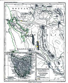

Franklin Land District is one of the twenty land districts of Tasmania which are part of the Cadastral divisions of Tasmania.[1] It used to be Franklin County, one of the 18 counties of Tasmania. Frenchmans Cap mountain is located there. It includes most of the Franklin-Gordon Wild Rivers National Park.
See also
 Australia portal

References
- ^ "LISTmap - Land Information System Tasmania". maps.thelist.tas.gov.au. Retrieved 6 June 2023.
- v
- t
- e
Western region of Tasmania, Australia
other settlements
- Braddon (federal)
- Braddon (state)
- Franklin Land District
- Montgomery Land District
- Montagu Land District
- West Coast Council
- Lyell
- Murchison
- Zeehan
| West Coast Range |
|
|---|
- Anthony Road
- Hercules Haulage
- Lyell Highway
- Murchison Highway
- Queenstown Airport
- Strahan Airport
| Railways | |
|---|---|
| Locomotives and rolling stock | |
| Railway stations and former railway stations |
|
| Natural | |
|---|---|
| Man-made |
newspapers


