Grandes Rousses
Mountain range in the French Alps


Grandes Rousses

Grandes Rousses
 France
- Isère
- Savoie
The Grandes Rousses are a massif in the French Alps located in the departments of Isère and Savoie. Oisans covers part of the massif.
Geography
Location
The massif is oriented north–south. The eastern slope, although it is sometimes considered to extend to the Galibier and Télégraphe passes and therefore including the Arves massif, is limited by the Arvan and Ferrand rivers.[1] The Eau d'Olle rivers and therefore the Belledonne range to the west, and Romanche and the Écrins massif to the south form its other geographical limits.
Main summits
- Pic Bayle, 3,465 m
- Pic de l'Étendard, 3,464 m
- Pic Blanc, 3,323 m
- Cimes de la Cochette, 3,241 m
- Cime de la Barbarate, 3,226 m
- Cime du Grand Sauvage, 3,216 m
- Dôme de la Cochette, 3,041 m
- Pic de l'Herpie, 3,012 m
- Roc de la Balme, 2,872 m
- Cime de la Valette, 2,858 m
- Dôme des Petites Rousses, 2,810 m
- Rissiou, 2,622 m
Main glaciers
- Rousses glacier
- Sarenne glacier
- Quirlies glacier
- Saint-Sorlin glacier
- Barbarate glacier
- Malatres glacier
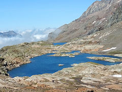
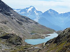
Main lakes
- Lac Blanc
- Lac des Quirlies
- Lac de la Fare
- Lac du Milieu
- Lac Besson
- Lac Noir
- Lac Carrelet
-
 Lac Carrelet
 -
 Lac du Milieu
 -
 Lac Noir
 -
 Lac Blanc
 -
 Lac Besson in winter


Geology
The Grandes Rousses massif is a crystalline geological formation similar to the nearby Belledonne range. It forms a long, north–south oriented chain, appearing as a northern extension of the Écrins massif. The massif is characterized by several north–south bands, many of which are separated by structural depressions from the late Hercynian period.[2] These depressions, likely synclines or grabens, are filled with coal-bearing lands, some of which show Triassic deposits lying at 90 degrees.
History
The Grandes Rousses massif is dotted with numerous abandoned mines. The most notable site is Brandes-en-Oisans, a mining village that operated silver mines from the 12th to the 14th century.[3] Located in the commune of Huez at an altitude of over 1,800 meters, Brandes-en-Oisans once had up to 80 buildings centered around a church.[4] Although of moderate importance on a European scale, Brandes was of significant importance to the Dauphiné region.
References
- ^ Ball, John; Coolidge, William Augustus Brevoort (1898). The Western Alps. Longmans, Green and Company. p. 127.
- ^ Bulletin des Services de la carte géologique de la France et des topographies souterraines (in French). Librairie Polytechnique, Baudry et Cie, Editeurs. 1895. p. 74.
- ^ "Site de Brandes". Mairie de l'Alpe d'Huez (in French). Retrieved 2024-06-17.
- ^ Bailly-Maître, Marie-Christine; Bruno-Dupraz, Joëlle (1994), "Le site de Brandes : ses atouts, son originalité", Brandes-en-Oisans : La mine d'argent des Dauphins (XIIe-XIVe siècles), Isère, DARA (in French), Lyon: Alpara, pp. 11–18, ISBN 978-2-916125-28-2, retrieved 2024-06-17
- v
- t
- e
(as per SOIUSA)
| South-western |
|
|---|---|
| North-western |
|

- Aiguilles Rouges
- Arves
- Baronnies
- Bauges
- Beaufortain
- Belledonne
- Bochaine
- Bornes
- Cerces
- Chambeyron
- Chartreuse
- Dévoluy
- Diois
- Écrins
- Escreins
- Giffre
- Gran Paradiso
- Grandes Rousses
- Lauzière
- Luberon
- Mercantour-Argentera
- Mont Blanc
- Mont Cenis
- Parpaillon
- Pelat
- Queyras
- Taillefer
- Trois-Évêchés
- Vanoise
- Vercors


