Großer Müllroser See
You can help expand this article with text translated from the corresponding article in German. (April 2018) Click [show] for important translation instructions.
- View a machine-translated version of the German article.
- Machine translation, like DeepL or Google Translate, is a useful starting point for translations, but translators must revise errors as necessary and confirm that the translation is accurate, rather than simply copy-pasting machine-translated text into the English Wikipedia.
- Do not translate text that appears unreliable or low-quality. If possible, verify the text with references provided in the foreign-language article.
- You must provide copyright attribution in the edit summary accompanying your translation by providing an interlanguage link to the source of your translation. A model attribution edit summary is
Content in this edit is translated from the existing German Wikipedia article at [[:de:Großer Müllroser See]]; see its history for attribution. - You may also add the template
{{Translated|de|Großer Müllroser See}}to the talk page. - For more guidance, see Wikipedia:Translation.
The Großer Müllroser See is a lake in Brandenburg, Germany. It is located in the district Oder-Spree between the town Müllrose in the north and the municipality Mixdorf in the south. The lake covers an area of 1,32 km². At an elevation of 41,6 m, its depth is maximal 8 m.
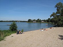
The lake is the largest water in the Schlaube Valley Nature Park and flown through by the river Schlaube, which runs over a distance of 20 kilometers through the Schlaube-Valley (German: Schlaubetal), a tunnel valley of the last glacial period. An approximately 9 kilometres long walking path leads around the lake. At the eastern and western shore there are public lidos/beaches, one of them with a diving tower. On the sea are operating some passenger ships. The watermill Müllrose at the northern shore was first mentioned in a document in 1275 and is still in use today.[1]
References
- ^ Hermann Trebbin: Müllrose - Aus den Schicksalen und Kämpfen einer märkischen Landstadt. Nachdruck der Ausgabe von 1934. Hrsg.: Stadt Müllrose, Verlag Die Furt, Jacobsdorf 2003, ISBN 3-933416-45-0.
External links
![]() Media related to Großer Müllroser See at Wikimedia Commons
Media related to Großer Müllroser See at Wikimedia Commons
- v
- t
- e


