Gyantse
Place in Tibet Autonomous Region, People's Republic of China
Gyantse 28°54′53″N 89°36′16″E / 28.9148°N 89.6045°E / 28.9148; 89.6045 | |
|---|---|
| Country | People's Republic of China |
| Province | Tibet Autonomous Region |
| Prefecture-level city | Shigatse |
| County | Gyantse |
| Population (2010) | |
| • Total | 11,039 |
| Time zone | UTC+8 (CST) |
Gyantse, officially Gyangzê Town (also spelled Gyangtse; Tibetan: རྒྱལ་རྩེ, Wylie: rgyal rtse, ZYPY: Gyangzê; simplified Chinese: 江孜镇; traditional Chinese: 江孜鎮; pinyin: Jiāngzī Zhèn), is a town located in Gyantse County, Shigatse Prefecture, Tibet Autonomous Region, China. It was historically considered the third largest and most prominent town in the Tibet region (after Lhasa, and Shigatse), but there are now at least ten larger Tibetan cities.[1]
History

In 1904, the British expedition to Tibet reached Gyantse on 11 April. The town's garrison had already fled, and the expedition's members entered the town bloodlessly through the front gates, which were opened for them, and occupied Gyantse. After the town was occupied, several British officers visited the Palcho Monastery and seized several statues and scrolls. During the occupation, the town's inhabitants continued to go about their business, and the expedition's medical officer, Herbert James Walton, attended to their medical needs, including performing several operations to correct the common problem of cleft palates. The expedition's officers spent time exploring the town and carrying out fishing or hunting trips in the surrounding countryside. Eventually, the expedition concluded a treaty with the Tibetan authorities, which stipulated that a British trade agent and garrison would be stationed at Gyantse.[2]
In 1919, Sir Walter Buchanan, a member of the Royal Geographical Society, travelled into the Chumbi Valley and visited the British garrison at Gyantse, describing it as "small" and noting that it consisted primarily of Indian troops.[3] During the reign of the 13th Dalai Lama, a military academy was established by the British in Gyantse to train Tibetan Army officers.[4] During World War II, the British continued to maintain a garrison in Gyantse, though it was eventually disbanded by 1947.[5][6][7]
Location
The town is strategically located in the Nyang Chu valley on the ancient trade routes from the Chumbi Valley, Yatung and Sikkim, which met here. From Gyantse, routes led to Shigatse downstream and also over the Kora La (Pass) to Central Tibet.[8] The fortress (constructed in 1390)[9] guarded the southern approaches to the Yarlung Tsangpo Valley and Lhasa.[10] The town was surrounded by a wall 3 km long.[11]
Demographics
In 1952, Gyantse had a population of perhaps 8,000 people,[12] about the same as in 2008.[13] It is 3,977 meters (13,050 ft) above sea level, and is located 254 km southwest of Lhasa in the fertile plain of the Nyang river valley and on a side branch of the Friendship Highway, which connects Kathmandu, Nepal to Lhasa. Gyantse was the third largest city in Tibet before being overtaken by Qamdo.
Landmarks
Gyantse is notable for its restored Gyantse Dzong or fort, and its magnificent tiered Kumbum (literally: '100,000 images') of the Palcho Monastery, the largest chörten in Tibet. The Kumbum was commissioned by a Gyantse prince in 1427 and was an important centre of the Sakya school of Tibetan Buddhism. This religious structure contains 77 chapels in its six floors, and is illustrated with over 10,000 murals, many showing a strong Nepali influence, which have survived almost entirely intact. They are the last of its kind to be found in Tibet. Many of the restored clay statues are of less artistry than the destroyed originals - but they are still spectacular.[14][15]


The town was nearly destroyed by flooding in 1954. After rioting in 1959, local industries were dismantled and artisans fled while others were placed in workcamps. Some 400 monks and laypeople were imprisoned in the monastery.[11] During the Cultural Revolution, the fort, the monastery and Kumbum were ransacked. Precious objects were destroyed or sent out of Tibet. The chorten was spared.[11]
The main building of the Pelkor Chode or Palcho Monastery and the Kumbum have been largely restored but the dzong or fort is still largely in ruins. During the 20th century, the Chinese government established the "Anti-British Imperialism Museum" in Gyantse, which exhibits the state narrative on the 1904 British expedition.[16] The sculpture that forms the centerpiece of the museum are two "Tibetan" warriors, but they were based on photos taken by Lt. G. J. Davys in Chumbi Valley of non-Tibetans doing fake battles, and the armor were worn backwards.[17]
Climate
Gyantse has an elevation-influenced humid continental climate (Köppen climate classification: Dwb).
| Climate data for Gyantse (1991–2020 normals) | |||||||||||||
|---|---|---|---|---|---|---|---|---|---|---|---|---|---|
| Month | Jan | Feb | Mar | Apr | May | Jun | Jul | Aug | Sep | Oct | Nov | Dec | Year |
| Mean daily maximum °C (°F) | 5.9 (42.6) | 7.6 (45.7) | 10.7 (51.3) | 13.9 (57.0) | 17.7 (63.9) | 21.1 (70.0) | 20.5 (68.9) | 19.7 (67.5) | 18.9 (66.0) | 15.4 (59.7) | 10.6 (51.1) | 7.3 (45.1) | 14.1 (57.4) |
| Daily mean °C (°F) | −3.8 (25.2) | −1.1 (30.0) | 2.6 (36.7) | 5.7 (42.3) | 9.6 (49.3) | 13.2 (55.8) | 13.0 (55.4) | 12.1 (53.8) | 10.8 (51.4) | 6.6 (43.9) | 0.8 (33.4) | −2.9 (26.8) | 5.6 (42.0) |
| Mean daily minimum °C (°F) | −13.1 (8.4) | −10.1 (13.8) | −5.8 (21.6) | −1.9 (28.6) | 2.1 (35.8) | 6.1 (43.0) | 7.4 (45.3) | 6.6 (43.9) | 4.2 (39.6) | −1.1 (30.0) | −7.6 (18.3) | −11.4 (11.5) | −2.0 (28.3) |
| Average precipitation mm (inches) | 0.3 (0.01) | 0.5 (0.02) | 1.7 (0.07) | 7.7 (0.30) | 16.9 (0.67) | 37.7 (1.48) | 89.3 (3.52) | 89.2 (3.51) | 34.7 (1.37) | 3.5 (0.14) | 0.5 (0.02) | 1.8 (0.07) | 283.8 (11.18) |
| Average precipitation days (≥ 0.1 mm) | 0.4 | 0.7 | 1.2 | 4.0 | 6.6 | 10.9 | 18.8 | 18.5 | 10.7 | 2.1 | 0.4 | 0.3 | 74.6 |
| Average snowy days | 0.8 | 1.1 | 2.2 | 5.9 | 3.2 | 0.2 | 0.1 | 0 | 0.3 | 1.4 | 0.7 | 0.5 | 16.4 |
| Average relative humidity (%) | 30 | 30 | 33 | 40 | 46 | 54 | 67 | 70 | 62 | 45 | 38 | 38 | 46 |
| Mean monthly sunshine hours | 272.2 | 251.5 | 276.2 | 273.1 | 295.9 | 273.4 | 224.6 | 224.6 | 244.3 | 294.0 | 283.6 | 280.9 | 3,194.3 |
| Percent possible sunshine | 83 | 79 | 74 | 70 | 70 | 66 | 53 | 56 | 67 | 84 | 89 | 88 | 73 |
| Source: China Meteorological Administration[18][19] | |||||||||||||
Footnotes
- ^ Dorje (1999), p. 254.
- ^ Chisholm 1911.
- ^ Sir Walter Buchanan, A recent trip into the Chumbi Valley, Tibet, The Royal Geographical Society, 1919.
- ^ Wang Jiawei et Nyima Gyaincain, The Tibetan Army's First Eastward Invasion Archived 27 September 2013 at the Wayback Machine, in The Historical Status of China's Tibet, China Intercontinental Press, 1997.
- ^ Hank Baker’s obituary notice, telegraph.co.uk, 4 March 2006.
- ^ Sanderson Beck, Tibet, Nepal, and Ceylon, 1800-1950.
- ^ BBC Radio 4 23 September 2013 11a.m http://www.bbc.co.uk/programmes/b03bdbq2
- ^ Dowman (1988), p. 269
- ^ Vitali (1990), p. 30.
- ^ Allen (2004), p. 30.
- ^ a b c Buckley, Michael and Strauss, Robert (1986), p. 158.
- ^ Richardson (1984), p. 7.
- ^ "Tibet: Transformation and tradition." BBC News 5 March 2008.
- ^ Dowman (1988), p. 270.
- ^ Mayhew (2005), p. 167.
- ^ Mayhew (2005), p. 168.
- ^ Harris (2012), p.130-135
- ^ 中国气象数据网 – WeatherBk Data (in Simplified Chinese). China Meteorological Administration. Retrieved 27 September 2023.
- ^ 中国气象数据网 (in Simplified Chinese). China Meteorological Administration. Retrieved 27 September 2023.
References
- Allen, Charles. (2004). Duel in the Snows: The True Story of the Younghusband Mission to Lhasa. John Murray (publishers), London. ISBN 0-7195-5427-6.
- Buckley, Michael and Strauss, Robert. 1986. Tibet: a travel survival kit. Lonely Planet Publications, South Yarra, Australia. ISBN 0908086881.
- Chisholm, Hugh, ed. (1911). "Gyantse" . Encyclopædia Britannica. Vol. 12 (11th ed.). Cambridge University Press. p. 751.
- Das, Sarat Chandra. 1902. Lhasa and Central Tibet. Reprint: Mehra Offset Press, Delhi. 1988. ISBN 81-86230-17-3
- Dorje, Gyurme. 1999. Footprint Tibet Handbook. 2nd Edition. Bath, England. ISBN 1-900949-33-4. Also published in Chicago, U.S.A. ISBN 0-8442-2190-2.
- Dowman, Keith. 1988. The Power-places of Central Tibet: The Pilgrim's Guide. Routledge & Kegan Paul, London and New York. ISBN 0-7102-1370-0
- Harris, Clare. 2012. The Museum on the Roof of the World: Art, Politics, and the Representation of Tibet. University of Chicago Press. ISBN 978-0-226-31747-2
- Mayhew, Bradley and Kohn, Michael. (2005). Tibet. Lonely Planet Publications. ISBN 1-74059-523-8.
- Richardson, Hugh E (1984). Tibet and its History. Second Edition, Revised and Updated. Shambhala Publications, Boston. ISBN 0-87773-376-7.
- Vitali, Roberto. Early Temples of Central Tibet. (1990). Serindia Publications. London. ISBN 0-906026-25-3.
- von Schroeder, Ulrich. (1981). Indo-Tibetan Bronzes. (608 pages, 1244 illustrations). Hong Kong: Visual Dharma Publications Ltd. ISBN 962-7049-01-8
- von Schroeder, Ulrich. (2001). Buddhist Sculptures in Tibet. Vol. One: India & Nepal; Vol. Two: Tibet & China. (Volume One: 655 pages with 766 illustrations; Volume Two: 675 pages with 987 illustrations). Hong Kong: Visual Dharma Publications, Ltd. ISBN 962-7049-07-7
- von Schroeder, Ulrich. 2008. 108 Buddhist Statues in Tibet. (212 p., 112 colour illustrations) (DVD with 527 digital photographs). Chicago: Serindia Publications. ISBN 962-7049-08-5
- Palin,Michael (2004). Himalaya with Michael Palin. (DVD Volume 4)
Gallery
-
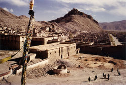
 A view of Gyantse from the top of its fortress
 -
 Old Gyantse and the Gyantse Dzong
 -
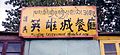 "Musilin Restaurant of the Hero City"
 -
 A street in Gyantse old town
 -
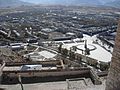
 Gyantse fort from Kumbum roof. 1993
 -
 Fortress wall. Gyantse. 1938.
 -
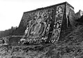 Huge thangka on thangka wall.
 -
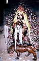 Palden Lhamo, Gyantse Gompa. 1993


External links
- v
- t
- e
- Gyangkar town
- Ri'og town
- Zhêntang town
- Dinggyê Township
- Dozhag Township
- Gojag Township
- Kyungzê Township
- Qab Township
- Sar Township
- Zhaxigang Township
- Gyangzê town
- Chêngring Township
- Dagzê Township
- Gyinkar Township
- Jagkyêr Township
- Jangra Township
- Kangcho Township
- Kardoi Township
- Karmai Township
- Lungmar Township
- Narong Township
- Nyangdoi Township
- Ralung Township
- Rasog Township
- Rinang Township
- Rixing Township
- Zangka Township
- Zhongzê Township
- Zêqên Township
- Dzongka town
- Kyirong Town
- Drakna Township
- Gungtang Township
- Trepa Township
- Salep Township
- Kamba town
- Changlung Township
- Kurmê Township
- Lungro Township
- Zhig Township
- Kangmar town
- Gala Township
- Kamru Township
- Nai'nying Township
- Nyingrungdoi Township
- Nyingrungmai Township
- Samarda Township
- Sapügang Township
- Xoinchêng Township
- Lhazê town
- Quxar town
- Chau Township
- Liu Township
- Mangpu Township
- Püncogling Township
- Qoima Township
- Rêsa Township
- Xiqên Township
- Zhaxigang Township
- Zhaxizom Township
- Namling town
- Car Township
- Dagna Township
- Dagzê Township
- Dobjoi Township
- Êma Township
- Gyamco Township
- Karzê Township
- Lhabupu Township
- Mangra Township
- Numa Township
- Pundam Township
- Qum Township
- Ratang Township
- Rindü Township
- Sogqên Township
- Tobgyai Township
- Kaika town
- Sangsang town
- Amxung Township
- Comai Township
- Dargyü Township
- Darog Township
- Dobê Township
- Goin'gyibug Township
- Kairag Township
- Kunglung Township
- Nyigo Township
- Qu'og Township
- Riwoqê Township
- Rusar Township
- Xungba Township
- Yamo Township
- Zazê Township
- Nyalam town
- Zham town
- Boro Township
- Mainpu Township
- Nailung Township
- Surco Township
- Yarlêb Township
- Dê'gyiling town
- Chagba Township
- Kangxung Township
- Moin Township
- Partang Township
- Pusum Township
- Qêwa Township
- Ramba Township
- Rinbung Township
- Gya'gya town
- Changgo Township
- Dênggar Township
- Lhagcang Township
- Ro'gyog Township
- Targyailing Township
- Xarru Township
- Xungru Township
- Gêding town
- Sa'gya town
- Chagjug Township
- Lalho Township
- Mabja Township
- Molha Township
- Sai Township
- Xaigar Township
- Xongma Township
- Xongmai Township
- Zhaxigang Township
- Ganggar town
- Xêgar town
- Chamso Township
- Cogo Township
- Gyaco Township
- Nyixar Township
- Kaimar Township
- Painji Township
- Qudêng Township
- Qulho Township
- Rongxar Township
- Zagor Township
- Zhaxizom Township
- Kagar town
- Capu Township
- Chuzhig Township
- Cobxi Township
- Dagmoxar Township
- Danagpu Township
- Lêba Township
- Moibaqêqên Township
- Namoqê Township
- Nartang Township
- Nyangra Township
- Qêqung Township
- Qingdü Township
- Rinqênzê Township
- Rungma Township
- Tarding Township
- Tongmoin Township
- Zêxoi Township
- Pagri town
- Xarsingma town
- Gyêru Township
- Kambu Township
- Shangyadong Township
- Tüna Township
- Xiayadong Township
- Paryang town
- Bodoi Township
- Gêla Township
- Gyêma Township
- Horba Township
- Labrang Township
- Lunggar Township
- Nagqu Township
- Painqi Township
- Parjang Township
- Rintor Township
- Yagra Township
- Qonkor Township


