Icacos River
River in Puerto Rico
- Río Icacos (Spanish)
- Río Hicacos (Spanish)
• location
• coordinates
The Icacos River (Spanish: Río Icacos), sometimes spelled Hicacos, is a river of Naguabo, Puerto Rico. It is 2.3 miles (3.7 km) long and has received the designation of "Wild and Scenic River" by the National Wild and Scenic Rivers System.[2] This river aids the hydroelectric dam in Naguabo.[3]
Río Icacos National Wild and Scenic River
The Icacos River has been designated a National Wild and Scenic River since 2009. The river is located within El Yunque National Forest and El Toro Wilderness, and it has some of the most varied terrain of any of the forest rivers.
The Icacos River flows into a three-river junction (together with the Cubuy and Prieto Rivers) through a series of waterfalls often called the Icacos Falls or Cubuy Falls, also located within the municipality of Naguabo.[4] This is the source of the Blanco River which flows southeast towards the Caribbean Sea in Río barrio, Naguabo.
Gallery
-
 Boulders in Icacos River
 -
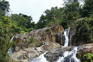 Waterfall in Icacos River


See also
- List of rivers of Puerto Rico
- Cayo Icacos
References
- ^ U.S. Geological Survey Geographic Names Information System: Río Icacos
- ^ a b "Rio Icacos". National Wild and Scenic River System.
- ^ Rivera Clemente, Yaritza (2021-06-03). "Los 20 embalses de la Isla permanecerán bajo responsabilidad de la AEE" [The AEE will continue to be responsible for these 20 island reservoirs]. El Vocero de Puerto Rico (in Spanish). Retrieved 2021-07-01.
- ^ National Wild and Scenic Rivers System. "Rio Icacos". rivers.gov.
External links
- USGS Hydrologic Unit Map – Caribbean Region (1974)
- Rios de Puerto Rico
- v
- t
- e


