Kamarang Airport
Airport


KAR
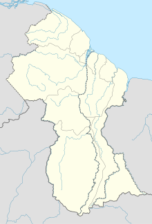
Location in Guyana
| Direction | Length | Surface | |
|---|---|---|---|
| m | ft | ||
| 07/25 | 1,000 | 3,281 | Asphalt |
Kamarang Airport (IATA: KAR, ICAO: SYKM) is an airport serving the town of Kamarang, in the Cuyuni-Mazaruni Region of Guyana.
The Kamarang non-directional beacon (Ident: KAM) is 2 kilometres (1.2 mi) north of the field.
The runway has been paved, the paved runway (asphalt) is 1220 metres long (4000') by 18 metres wide (60').
See also
 Guyana portal
 Aviation portal
- List of airports in Guyana
- Transport in Guyana
References
External links

Wikimedia Commons has media related to Kamarang Airport.
- Kamarang Airport
- OpenStreetMap - Kamarang
- OurAirports - Kamarang
- SkyVector Aeronautical Charts
- v
- t
- e
Airports in Guyana
- Aishalton
- Annai
- Apoteri
- Awaruwaunau
- Baramita
- Bartica
- Ebini
- Georgetown
- Georgetown/Ogle
- Imbaimadai
- Kaieteur National Park
- Kamarang
- Karanambo
- Karasabai
- Kato
- Kurukabaru
- Lethem
- Linden
- Lumid Pau
- Mabaruma
- Mahdia
- Monkey Mountain
- Mountain Point
- New Amsterdam
- Orinduik
- Paramakatoi
- Paruima
- Port Kaituma
 | This article about an airport in Guyana is a stub. You can help Wikipedia by expanding it. |
- v
- t
- e


