List of bridges in Perth, Western Australia
Map all coordinates using OpenStreetMap
Download coordinates as:
- KML
- GPX (all coordinates)
- GPX (primary coordinates)
- GPX (secondary coordinates)
This is a list of major bridges in Perth, Western Australia. Most bridges cross either the Swan River or the Canning River, the two main rivers that traverse the Swan Coastal Plain. Others are overpasses for major roads.
Road bridges
| Name | Image | Length | Location | Coordinates | Carries | Crosses | Notes |
|---|---|---|---|---|---|---|---|
| Barrack Street Bridge |  | Perth | 31°57′07″S 115°51′42″E / 31.95191°S 115.86156°E / -31.95191; 115.86156 (Barrack Street Bridge) | Beaufort Street[1] | Fremantle railway line | ||
| Canning Bridge | 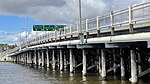 | 175 m (574 ft) | Como – Applecross | 32°0′39.5″S 115°51′11.5″E / 32.010972°S 115.853194°E / -32.010972; 115.853194 (Canning Bridge) | Canning Highway | Canning River | |
| The Causeway |  | 341 m (1,120 ft) | East Perth – Victoria Park | 31°58′0.5″S 115°53′9.6″E / 31.966806°S 115.886000°E / -31.966806; 115.886000 (The Causeway) | The Causeway (road) | Swan River | Comprises two bridges meeting at Heirisson Island |
| Fremantle Traffic Bridge |  | 230 m (750 ft) | North Fremantle – Fremantle | 32°02′28″S 115°45′17″E / 32.0410°S 115.7546°E / -32.0410; 115.7546 (Fremantle Traffic Bridge) | Queen Victoria Street | Swan River | |
| Garratt Road Bridge |  | 240 m (790 ft) | Bayswater – Ascot | 31°55′57″S 115°54′59″E / 31.9324°S 115.9164°E / -31.9324; 115.9164 (Garratt Road Bridge) | Garratt Road | Swan River | |
| Horseshoe Bridge |  | 280 m (920 ft) | Perth | 31°57′3″S 115°51′34″E / 31.95083°S 115.85944°E / -31.95083; 115.85944 (Horseshoe Bridge) | William Street | Fremantle railway line | |
| Mooro-Beeloo Bridge |  | 271 m (889 ft) | Bayswater – Redcliffe | 31°55′48.7″S 115°56′13.3″E / 31.930194°S 115.937028°E / -31.930194; 115.937028 (Redcliffe Bridge) | Tonkin Highway | Swan River | Known as Redcliffe Bridge until December 2023 |
| Mount Henry Bridge |  | 660 m (2,170 ft) | Salter Point – Brentwood | 32°2′0″S 115°51′31″E / 32.03333°S 115.85861°E / -32.03333; 115.85861 (Mount Henry Bridge) | Kwinana Freeway | Canning River | Also a railway bridge |
| Narrows Bridge |  | 397 m (1,302 ft) | Perth – South Perth | 31°57′48″S 115°50′49″E / 31.96333°S 115.84694°E / -31.96333; 115.84694 (Narrows Bridge) | Kwinana Freeway | Swan River | Three parallel bridges; also a railway bridge |
| Riverton Bridge |  | 100 m (330 ft) | Riverton – Wilson | 32°1′40.2″S 115°54′4.75″E / 32.027833°S 115.9013194°E / -32.027833; 115.9013194 (Riverton Bridge) | Fern Road | Canning River | |
| Shelley Bridge | 240 m (790 ft) | Shelley – Wilson | 32°01′25″S 115°54′06″E / 32.0237°S 115.9017°E / -32.0237; 115.9017 (Shelley Bridge) | Leach Highway | Canning River | ||
| Stirling Bridge |  | 400 m (1,300 ft) | North Fremantle – East Fremantle | 32°02′21″S 115°45′33″E / 32.0392°S 115.7593°E / -32.0392; 115.7593 (Stirling Bridge) | Stirling Highway | Swan River | |
| Walley Bridge |  | 61 m (200 ft) | Wellard – Baldivis | 32°16′18″S 115°50′42″E / 32.2718°S 115.8451°E / -32.2718; 115.8451 (Walley Bridge) | Kwinana Freeway | Millar Road, Rail Line 13 | |
| Windan Bridge |  | 406 m (1,332 ft) | East Perth – Burswood | 31°56′51″S 115°52′58″E / 31.9474°S 115.8828°E / -31.9474; 115.8828 (Windan Bridge) | Graham Farmer Freeway | Swan River | Runs alongside Goongoongup Bridge |
Railway bridges
| Name | Image | Location | Coordinates | Carries | Crosses | Notes |
|---|---|---|---|---|---|---|
| Bunbury Bridge |  | East Perth | 31°56′53″S 115°52′58″E / 31.94794°S 115.88286°E / -31.94794; 115.88286 (Bunbury Bridge) | Swan River | 1930 to 1996 | |
| Goongoongup Bridge |  | East Perth – Burswood | 31°56′52″S 115°52′58″E / 31.9477°S 115.8829°E / -31.9477; 115.8829 (Goongoongup Bridge) | Armadale and Thornlie railway lines | Swan River | 1995 to present |
| Mount Henry Bridge | | Salter Point – Brentwood | 32°2′0″S 115°51′31″E / 32.03333°S 115.85861°E / -32.03333; 115.85861 (Mount Henry Bridge) | Mandurah railway line | Canning River | |
| Narrows Bridge | | Perth – South Perth | 31°57′48″S 115°50′49″E / 31.96333°S 115.84694°E / -31.96333; 115.84694 (Narrows Bridge) | Mandurah railway line | Swan River |
Pedestrian bridges
| Name | Image | Location | Coordinates | Crosses |
|---|---|---|---|---|
| Elizabeth Quay Bridge |  | Perth | 31°57′33″S 115°51′21″E / 31.95923°S 115.85581°E / -31.95923; 115.85581 (Elizabeth Quay Bridge) | Elizabeth Quay |
| Matagarup Bridge |  | East Perth | 31°57′14″S 115°53′06″E / 31.954°S 115.885°E / -31.954; 115.885 (Matagarup Bridge) | Swan River |
| The Kids' Bridge |  | Nedlands | Winthrop Avenue | |
| Trafalgar Bridge | 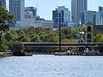 | East Perth | 31°57′07″S 115°52′49″E / 31.95193°S 115.88022°E / -31.95193; 115.88022 (Trafalgar Bridge) | Claisebrook Cove |
See also
- Swan River (Western Australia) § Bridges
References
- ^ Main Roads Western Australia. Road Information Mapping System (Map). Government of Western Australia. Structure Number 0949A. Retrieved 1 May 2019.
General references
- Main Roads Western Australia (June 2014). "Special Purpose Vehicle Restricted Bridges: Perth Metropolitan and Mandurah Area" (PDF) (24th ed.). Government of Western Australia. Archived from the original (PDF) on 16 December 2014. Retrieved 25 January 2021.
External links
 Media related to Bridges in Perth, Western Australia at Wikimedia Commons


