Loch Restil
Freshwater Loch in Argyll and Bute, Scotland.
56°13′50″N 4°51′31″W / 56.230557°N 4.8585287°W / 56.230557; -4.8585287grid reference NN 22904 07899
Loch Restil is a freshwater loch that lies in the pass between Glen Croe and Glen Kinglas on the Cowal peninsula, Argyll and Bute, West of Scotland. One of the main roads to the west of Scotland coast, the A83, passes Loch Restil.[1][2] The burn that flows from Loch Restil is one of the feeds of Kinglas Water, in Glen Kinglas, which flows under the Butter Bridge.[3]
Loch Restil lies within the Argyll Forest Park which is itself a part of the Loch Lomond and The Trossachs National Park.[4][5]
- Loch Restil
-
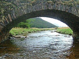 Old road bridge near Butterbridge farm - geograph.org.uk - 14088
 -
 View North from A83 alongside Loch Restil - geograph.org.uk - 20557


References
External links
 Scotland portal

Wikimedia Commons has media related to Loch Restil.
- Map sources for Loch Restil
- British Lakes Info - website
- Sabre-Roads.org.uk: Butter Bridge
- Argyll Forest Park - website
- Loch Lomond and The Trossachs National Park - website


