Mamloo Dam
Dam
35°35′47″N 51°47′13″E / 35.59639°N 51.78694°E / 35.59639; 51.78694https://thrw.ir/st/83
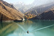
Mamloo Dam (Persian: سد ماملو), is a dam in the Central Alborz mountain range of northern Iran near to the Mount Damavand.The reservoir created by the dam has a capacity of about 250 million cubic meters and [1] It has been built to meet the needs of agricultural water in Varamin plain, but due to the drinking water supply in Tehran, a limited amount of stored water is supplied to the plain. One of the most important effects of the insufficient supply of surface water in Varamin plain is the reduction of groundwater aquifers and land subsidence[2]
It is located 35 kilometres (22 mi) east of Tehran and 49 kilometres (30 mi) southeast of Mount Damavand.
See also
- Dams in Iran
References
- ^ "امور بهره برداری سد ماملو". thrw.ir/.
- ^ Rajabi, Ali M.; Ghorbani, E. (December 2016). "Land subsidence due to groundwater withdrawal in Arak plain, Markazi province, Iran". Arabian Journal of Geosciences. 9 (20): 738. Bibcode:2016ArJG....9..738R. doi:10.1007/s12517-016-2753-7. ISSN 1866-7511. S2CID 132347236.
- v
- t
- e

- Alavian Dam
- Amir Kabir Dam
- Azad Dam
- Bust-e gez Dam
- Daryan Dam
- Dez Dam
- Doroodzan Dam
- Ashavan Dam
- Garan Dam
- Gavoshan Dam
- Giz Galasi Dam
- Cheragh Veys Dam
- Iran–Turkmenistan Friendship Dam
- Jiroft dam
- Shahid Abbaspour Dam
- Masjed Soleyman Dam
- Karun-3 Dam
- Karun-4 Dam
- Karkheh dam
- Khoda Afarin Dam
- Kouhrang 1 Dam
- Kouhrang 2 Dam
- Lar Dam
- Latyan Dam
- Mahabad Dam
- Mamloo Dam
- Marun Dam
- Rudbar Lorestan Dam
- Sardasht Dam
- Sefidrud Dam
- Seimare Dam
- Shahid Kazemi Dam
- Shahid Rajaee Dam
- Shahid Talebi Dam
- Shamo Dam
- Siah Bishe Pumped Storage Power Plant
- Silveh Dam
- Sivand Dam
- Sumbar Dam
- Tarik Dam
- Upper Gotvand Dam
- Zayanderud Dam
Also See: Dams and reservoirs in Iran
 | This article about a dam or floodgate in Iran is a stub. You can help Wikipedia by expanding it. |
- v
- t
- e


