Marsilac
District of São Paulo, Brazil
23°53′13″S 46°42′50″W / 23.887°S 46.714°W / -23.887; -46.714
Place in São Paulo, Brazil
Marsilac | |
|---|---|
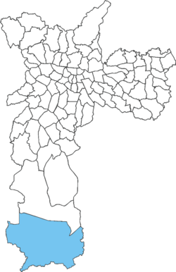 Location of Marsilac in São Paulo | |
| Country |  Brazil Brazil |
| State |  São Paulo São Paulo |
| Municipality |  São Paulo São Paulo |
| Subprefecture | Parelheiros |
| Area | |
| • Total | 200 km2 (80 sq mi) |
| Population (2007) | |
| • Total | 8,258 |
| • Density | 41/km2 (110/sq mi) |
| Website | Subprefecture of Parelheiros |
Marsilac is one of 96 districts of São Paulo, Brazil, located in the extreme south tip of the city in the subprefecture of Parelheiros.[1] Its name is a tribute to engineer Jose Alfredo Marsilac, who developed many techniques for building roads and tunnels, even after losing 99% of his vision from being hit by a bomb in the Revolution of 1932.
History
Early settlement of the area owed mainly to the construction of the Mairinque–Santos by Estrada de Ferro Sorocabana connecting Mairinque and Santos, completed in 1935. Along its extension, there were three stations in the district: Engineer Marsilac (which gave name to the surrounding neighborhood and later to its own district), Evangelista de Souza, and Rio de Campos.
Features
Located near the Serra do Mar and almost entirely rural, Marsilac has the largest land area of the municipality, equivalent to all of the municipality's central area. It also has the lowest population density of all the districts, largely covered by reserves of the Atlantic Forest.
This is the most remote district of the capital, located about 60–70 kilometers from Marco Zero and only about 10–15 km from the Atlantic Ocean, which is visible from some points. It borders the municipalities of São Vicente and Itanhaém. A tiny area of the town lies at sea level, located in the Capivari River valley.
It is the poorest district and has the lowest Human Development Index (HDI) of the city of São Paulo.
Adjacent districts and municipalities
- Parelheiros (North)
- Municipality of São Bernardo do Campo (East)
- City of Itanhaém and São Vicente (South)
- City of Juquitiba and Embu-Guaçu (West)
Neighborhoods of Marsilac
- Banhado
- Bela Vista
- Capivari
- Cipó do Meio
- Chácara Sanni
- Embura
- Parque Florestal Paulista
- Chácara Galo Azul
- Parque Internacional
- Chácara Itajaá
- Mambu
- Engenheiro Marsilac
- Evangelista de Sousa
- Gramado
- Jardim dos Eucaliptos
- Paiol
- Ponte Alta
See also
- Roman Catholic Diocese of Santo Amaro
- Line 9 (CPTM) of Train
- Railway Line Santos-Jundiaí
- Colônia crater
- Guarapiranga reservoir
- Parelheiros-Itanhaém Highway 57
References
- ^ "Dados Demográficos dos Distritos pertencentes as Subprefeituras". prefeitura.sp.gov.br (in Portuguese). City of São Paulo. Archived from the original on 4 February 2015. Retrieved 28 December 2014.
External links
- Roman Catholic Diocese of Santo Amaro
- Parelheiros News
- Sheet of My Sampa
- Grajaú News
- v
- t
- e

- Aricanduva
- Butantã
- Campo Limpo
- Capela do Socorro
- Casa Verde
- Cidade Ademar
- Cidade Tiradentes
- Ermelino Matarazzo
- Freguesia-Brasilândia
- Guaianases
- Ipiranga
- Itaim Paulista
- Itaquera
- Jabaquara
- Jaçanã-Tremembé
- Lapa
- M'Boi Mirim
- Mooca
- Parelheiros
- Penha
- Perus
- Pinheiros
- Pirituba-Jaraguá
- Santana-Tucuruvi
- Santo Amaro
- São Mateus
- São Miguel Paulista
- Sé
- Sapopemba
- Vila Maria-Vila Guilherme
- Vila Mariana
- Vila Prudente
- Água Rasa
- Alto de Pinheiros
- Anhanguera
- Aricanduva
- Artur Alvim
- Barra Funda
- Bela Vista
- Belém
- Bom Retiro
- Brasilândia
- Brás
- Butantã
- Cachoeirinha
- Cambuci
- Campo Belo
- Campo Grande
- Campo Limpo
- Cangaíba
- Capão Redondo
- Carrão
- Casa Verde
- Cidade Ademar
- Cidade Dutra
- Cidade Líder
- Cidade Tiradentes
- Consolação
- Cursino
- Ermelino Matarazzo
- Freguesia do Ó
- Grajaú
- Guaianases
- Iguatemi
- Ipiranga
- Itaim Bibi
- Itaim Paulista
- Itaquera
- Jabaquara
- Jaçanã
- Jaguara
- Jaguaré
- Jaraguá
- Jardim Helena
- Jardim Paulista
- Jardim São Luís
- Jardim Ângela
- José Bonifácio
- Lajeado
- Lapa
- Liberdade
- Limão
- Mandaqui
- Marsilac
- Moema
- Mooca
- Morumbi
- Parelheiros
- Pari
- Parque do Carmo
- Pedreira
- Penha
- Perdizes
- Perus
- Pinheiros
- Pirituba
- Ponte Rasa
- Raposo Tavares
- República
- Rio Pequeno
- Sacomã
- Santa Cecília
- Santana
- Santo Amaro
- São Domingos
- São Lucas
- São Mateus
- São Miguel Paulista
- São Rafael
- Saúde
- Sapopemba
- Sé
- Socorro
- Tatuapé
- Tremembé
- Tucuruvi
- Vila Andrade
- Vila Curuçá
- Vila Formosa
- Vila Guilherme
- Vila Jacuí
- Vila Leopoldina
- Vila Maria
- Vila Mariana
- Vila Matilde
- Vila Medeiros
- Vila Prudente
- Vila Sônia
City Districts of São Paulo | ||
|---|---|---|
|  | |
 | This geographical article relating to the state of São Paulo is a stub. You can help Wikipedia by expanding it. |
- v
- t
- e


