Menominee Pier Light
Lighthouse in Michigan, United States
Lighthouse
45°05′50.2″N 87°35′9.6″W / 45.097278°N 87.586000°W / 45.097278; -87.586000[1]Menominee Pierhead Light Station
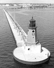
The Menominee North Pier lighthouse is located in the harbor of Menominee, Michigan. The station was first lit in 1877. The current structure and its still operational light was lit in 1927, and automated in 1972.[3] It is also sometimes called the "Menominee (Marinette) North Pierhead Light".[4]
The foundation is a concrete pier. The 34-foot (10 m) tall octagonal cast iron building is marked in a distinctive red, with a black lantern and white base. A Fourth Order Fresnel lens was originally installed, but was replaced with a modern 12-inch (300 mm) acrylic optic lens.[5] The original lens is now at Sand Point Light in Escanaba, Michigan.[6] The focal plane is 46 feet (14 m).[7]
The building originally had a diaphone fog signal structure attached, and it was later removed. The iron catwalk was removed in 1972 when the light was automated.[8]
This light is paired with a large rear range light.[9] That is denominated the Menominee (Marinette) North Pier light, and is also an active aid to navigation. Its focal plane 59 feet (18 m), and its characteristic is a continuous red light. The tower is a 50-foot (15 m)square pyramidal steel skeletal tower with gallery. It is painted red, and located on the Menominee North Pier about 600 feet (180 m) from the pierhead light.[10] It may be accessed by walking the pier. The site is open, but the tower is closed. U.S. Coast Guard. USCG 7-21940.[4]
-
 Undated USCG aerial photo, showing catwalk (since removed)
 -
 Early undated USCG image of light and attached fog signal building


References
- ^ a b Light List, Volume VII, Great Lakes (PDF). Light List. United States Coast Guard.
- ^ "National Register Information System". National Register of Historic Places. National Park Service. July 9, 2010.
- ^ "Historic Light Station Information and Photography: Michigan". United States Coast Guard Historian's Office. Archived from the original on 2017-05-01.
- ^ a b Rowlett, Russ. "Lighthouses of the United States: Michigan's Eastern Upper Peninsula". The Lighthouse Directory. University of North Carolina at Chapel Hill.
- ^ Terry Pepper, Seeing the Light, 300 mm. acrylic optic lens.
- ^ Wobser, David, Menoninee Pier Light Archived 2008-09-07 at the Wayback Machine at Boatnerd.com.
- ^ National Park Service, Maritime Heritage Inventory of Historic Lights, Menoninee Pier Light.
- ^ Terry Pepper, Seeing the Light, Menoninee Pier Light.
- ^ "Lighthoues R US, Menoninee Pier Lights". Archived from the original on 2008-05-04. Retrieved 2008-05-07.
- ^ See the photo, National Park Service, Maritime Heritage Inventory of Historic Lights, Menoninee North Pier Light.
External links
![]() Media related to Menominee Pier Light at Wikimedia Commons
Media related to Menominee Pier Light at Wikimedia Commons
- Detroit News, Interactive map on Michigan lighthouses.
- Interactive map of Lights in Northern Lake Michigan, mapped by Google.
- Lighthouse Central, Menominee North Pier Light, The Ultimate Guide to Upper Michigan Lighthouses by Jerry Roach.. (Publisher: Bugs Publishing LLC - 2007). ISBN 978-0-9747977-2-4.
- Light List, Volume VII, Great Lakes (PDF). Light List. United States Coast Guard.
- v
- t
- e
- Au Sable
- Big Bay Point
- Copper Harbor
- Copper Harbor Front Range
- Crisp Point
- Eagle Harbor
- Eagle Harbor Range Lights
- Eagle River
- Fourteen Mile Point
- Grand Island East Channel
- Grand Island Harbor Rear Range
- Grand Island North
- Grand Marais Range Lights
- Granite Island
- Gull Rock
- Huron Island
- Isle Royale
- Manitou Island
- Marquette Breakwater Outer
- Marquette Harbor
- Mendota (Bete Grise)
- Munising Front Range
- Munising Rear Range
- Ontonagon
- Ontonagon Harbor West Breakwater
- Portage River (Jacobsville)
- Passage Island
- Presque Isle Harbor Breakwater Light
- Rock Harbor
- Rock of Ages
- Sand Hills
- Sand Point Light (Baraga)
- St. Martin Island
- Stannard Rock
- Thunder Bay Island
- Whitefish Point

- DeTour Reef
- Lansing Shoals
- Manistique East Breakwater
- Martin Reef
- Menominee Pier
- Minneapolis Shoal
- Naubinway Island
- Peninsula Point
- Poverty Island
- Sand Point
- Seul Choix
- Squaw Island
- St. Martin Island
- Frying Pan Island
- Pipe Island
- Point Iroquois
- Round Island Light (St. Mary's River)
- Six Mile Point Range Rear
- Winter Point Range Front
- Keweenaw Waterway Lower Entrance
- Keweenaw Waterway Upper Entrance
- Portage Lake
- Rouleau Point Range Front and Rear Lights
- Beaver Island Harbor
- Beaver Island Head
- Big Sable Point
- Cedar River
- Charlevoix
- Charlevoix South Pier
- Frankfort
- Frankfort South Range
- Grand Haven North Pierhead
- Grand Haven South Pierhead Entrance
- Grand Haven South Pierhead Inner
- Grand Traverse
- Grays Reef
- Holland Harbor
- Ile Aux Galets
- Little Sable Point
- Little Traverse
- Ludington
- Manistee Pierhead
- Manning Memorial
- Mission Point
- Mission Point (1933)
- Muskegon Breakwater
- Muskegon Pier
- North Manitou Shoal
- Pentwater North Pierhead
- Pentwater South Pierhead
- Point Betsie
- Portage Lake
- South Fox Island
- South Haven
- South Manitou Island
- St. Joseph North Pier Inner
- St. Joseph North Pier Outer
- Waugoshance
- White River
- White Shoal
- Alpena
- Caseville Harbor
- Charity Island
- Cheboygan Crib
- Cheboygan River Front Range
- Detroit River
- Fort Gratiot
- Forty Mile Point
- Fourteen Foot Shoal
- Gibraltar
- Gravelly Shoal
- Harbor Beach
- Lake St. Clair
- Mariners Memorial
- Middle Island
- Miller Memorial
- New Presque Isle
- Old Presque Isle
- Peche Island Rear Range
- Poe Reef
- Pointe aux Barques
- Port Austin
- Port Sanilac
- Saginaw Bay
- Saginaw River Rear Range
- Spectacle Reef
- St. Clair Flats Front and Rear Range Light
- Sturgeon Point
- Tawas Point
- Thunder Bay Island
- Tri-Centennial Light of Detroit
- William Livingstone Memorial
- Windmill Point
- Au Sable North Pierhead
- Belle Isle
- Clinton River
- Ecorse
- Ecorse Range Rear
- Gibraltar
- Grassy Island
- Grassy Island North Channel Range Lights
- Grassy Island South Channel Range Lights
- Grosse Ile North Channel Range Lights
- Grosse Ile South Channel Range Lights
- Harwood Point East Range Front
- Kalamazoo River
- Mama Juda
- Mama Juda Range Front
- Manistee Main
- Middle Lake George
- Monroe Pier
- New Buffalo
- North Manitou Island
- Saginaw Bay
- Sand Beach North Entrance East
- Squaw Point
- St. Mary's River Lower Range Front
- Vidal Shoals Channel Range Front and Rear Lights
- Windmill Point Range Front and Rear Lights
- Lightship Huron
- List of lifesaving stations in Michigan
- Wixom Lake, Musselman Island lighthouse
| |
|---|---|
| Topics | |
| Lists by state |
|
| Lists by insular areas | |
| Lists by associated state | |
| Other areas | |
| Related | |
| |


| Authority control databases: Geographic |
|
|---|


