Mount Trumbull Wilderness
Protected area in Mohave County, Arizona
36°24′29″N 113°07′41″W / 36.408°N 113.128°W / 36.408; -113.128The Mount Trumbull Wilderness is a 7,880 acre (31 km2) wilderness area located on the Uinkaret Plateau in the Arizona Strip. It is managed by the Bureau of Land Management.
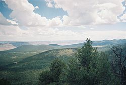
The Mount Trumbull Wilderness is north of Grand Canyon National Park and in the Grand Canyon-Parashant National Monument. It is approximately 60 miles southwest of Fredonia, Arizona and about 60 miles south of St. George, Utah. It is about 7 miles north of the Mount Logan Wilderness.
The namesake of the wilderness, Mt. Trumbull, is 8,028 feet (2,446m) at its highest point. A 2.5 mile trail to the top can be accessed from Mohave County Road 5. The mountain was named by John Wesley Powell after the Illinois Senator Lyman Trumbull.[1]
Flora

At lower elevations the vegetation of the wilderness consists of Utah juniper (Juniperus osteosperma), pinyon pine, Mojave yucca (Yucca schidigera), and sagebrush (Artemisia tridentata). Moving up, the vegetation slowly changes into ponderosa pines. The area was heavily logged in the late 19th century resulting in most ponderosas being new growth, thus small, but some towering old growth ponderosa pines can be seen in the Wilderness that are more than 500 years old. There are also various types of grasses which grow intermittently throughout the wilderness.
Fauna
The wilderness is home to a variety of animals. Mule deer are a common sight in the mornings and late afternoons. There are a large number of squirrels including the Kaibab squirrel, transplanted to the area from the south rim of the Grand Canyon in the 1970s. Other more rare animals include pronghorn deer and mountain lions. There are also a variety of lizards in the area including horned lizards. Birds present include red crossbills, Steller's jays, common ravens and many others.
Geology
The Mt. Trumbull mesa is capped by a 3.6 million year old dark grey basalt lava flow, one of the first eruptions in the Uinkaret volcanic field. The volcanic field has spawned at least 213 known eruptions since then, including seventeen lava flows that poured into the Grand Canyon and dammed the Colorado River.[2] The most recent eruption was at Little Springs approximately 960 years ago.[3] Its lava flow can be seen just south of Mt. Trumbull along BLM road 1044. The Mt. Trumbull lava flow cap protects the colorful Moenkopi Formation beneath that would have otherwise been eroded away long ago. An undated and unnamed cinder cone sits on top of the mesa. It erupted through the original 3.6 million year old basalt cap likely in the last few hundred thousand years based on minimal surface erosion. It ejected bright red volcanic cinders and lava bombs which can be seen along the switchback trail.
Archaeology
The wilderness contains both prehistoric and historic archaeological sites. The Ancestral Puebloans are known to have inhabited the area, and an archaeological field school is conducted in and around the area each summer 1. In historic times the members of the Church of Jesus Christ of Latter-Day Saints used the area to harvest lumber to build many of the structures in St George, Utah.
See also
Wikimedia Commons has media related to Mount Trumbull Wilderness.
References
- ^ Powell, John Wesley. The Exploration of the Colorado River and its Canyons. 1961, Dover Publications, New York.
- ^ https://pubs.geoscienceworld.org/gsa/geosphere/article/11/5/1305/132253/A-new-model-for-Quaternary-lava-dams-in-Grand [bare URL]
- ^ "The Little Springs Eruption at Mt. Trumbull - Grand Canyon-Parashant National Monument (U.S. National Park Service)".
External links
- BLM Mt. Trumbull site
- Mt. Trumbull at wilderness.net
- USGS geologic maps of the area
- Joshn Wesley Powell's description of the area
- v
- t
- e
(Yavapai County)
- Boundary Cone
- Fortification Hill
- Mount Wilson
- Mount Union
- Castle Dome
- Carr Peak
- Miller Peak
- Aubrey Peak
- Hualapai Peak
- Lime Peak
- Mae West Peaks
- Four Peaks
- Mount Ord
- East End
- McDowell Peak
- Mount McDowell
- Thompson Peak
- Mount Ballard (Arizona)
- Camelback Mountain
- Mummy Mountain
- Piestewa Peak
- South Mountains
- Sunnyslope Mountain
- Ibex Peak
- Agassiz Peak
- Doyle Peak
- Fremont Peak
- Mount Bigelow
- Mount Lemmon
- Pusch Ridge
- Thimble Peak
- Mount Hopkins
- Mount Wrightson
- Mount Turnbull
- Mistake Peak
- Granite Mountain
- Black Dome
- Sentinel Peak
- Tumamoc Hill
- Apache Peak
- Black Mesa (Navajo County)
- Escudilla Mountain
- Mount Baldy
- Agathla Peak
- Agua Caliente Mountains
- Agua Dulce Mountains
- Antelope Hill
- Aquarius Mountains
- Artillery Mountains
- Atascosa Mountains
- Aubrey Hills
- Baboquivari Peak
- Balakai Mesa
- Beaver Dam Mountains
- Belmont Mountains
- Bill Williams Mountain
- Bitsihuitsos Butte
- Black Hills (Greenlee County)
- Black Mesa (Apache-Navajo Counties)
- Black Mesa (Warm Springs)
- Black Mountain (Maricopa County)
- Black Mountain (Pima County)
- Blackjack Mountains
- Bryan Mountains
- Buckskin Mountain (Arizona-Utah)
- Buckskin Mountains (La Paz County)
- Bush Head
- Cabeza Prieta Mountains
- Canelo Hills
- Carrizo Mountains
- Cerro Colorado Mountains
- Chocolate Mountains
- Copper Mountains
- Coyote Mountains
- Date Creek Mountains
- Dome Rock Mountains
- Dos Cabezas Mountains
- Etoi Ki
- Excalibur
- Galiuro Mountains
- Gavilan Peak
- Gila Bend Mountains
- Gila Mountains (Graham County)
- Gila Mountains (Yuma County)
- Goldfield Mountains
- Grand Wash Cliffs
- Granite Mountains
- Granite Wash Mountains
- Growler Mountains
- Gu Achi Peak
- Guadalupe Mountains
- Harcuvar Mountains
- Harquahala Mountains
- House Mountain
- Hunts Mesa
- Isis Temple
- John the Baptist Mountains
- Juniper Mesa
- Kaibab Plateau
- Kofa Mountains
- Laguna Mountains
- Las Guijas Mountains
- Lime Mountain (Maricopa County}
- Little Harquahala Mountains
- Little Rincon Mountains
- Lukachukai Mountains
- Madrean Sky Islands
- Mescal Mountains
- Mineral Mountains
- Moccasin Mountains
- Mohave Mountains
- Mohawk Mountains
- Mount Trumbull
- Muggins Mountains
- Mustang Mountains
- Navajo Mountain
- The Needles
- New River Mountains
- New Water Mountains
- Newton Butte
- Painted Rock Mountains
- Pajarito Mountains
- Patagonia Mountains
- Peacock Mountains
- Picacho Peak
- Picketpost Mountain
- Pinnacle Peak
- Poachie Range
- Poston Butte
- Rawhide Mountains
- Sacaton Mountains
- San Luis Mountains
- Santa Maria Mountains
- Sevenmile Mountains
- Sierra San Antonio
- Sierra Estrella
- Sierra Madre Occidental
- Sierra Pinta
- Silver Bell Mountains
- Squaw Tits
- Sugarloaf Mountain
- Sunset Mountains
- Swisshelm Mountains
- Tempe Butte
- Temple Butte
- Tinajas Altas Mountains
- Tordillo Mountain
- Tortolita Mountains
- Trigo Mountains
- Tule Mountains
- Tumacacori Mountains
- Virgin Mountains
- Vulcan's Throne
- Vulture Mountains
- Waterman Mountains
- Weaver Mountains
- West Silver Bell Mountains
- White Tank Mountains
- Wickenburg Mountains


