National Register of Historic Places listings in Collier County, Florida

This is a list of the National Register of Historic Places listings in Collier County, Florida.
This is intended to be a complete list of the properties and districts on the National Register of Historic Places in Collier County, Florida, United States. The locations of National Register properties and districts for which the latitude and longitude coordinates are included below, may be seen in a map.[1]
There are 19 properties and districts listed on the National Register in the county.
This National Park Service list is complete through NPS recent listings posted May 10, 2024.[2]
Map all coordinates using OpenStreetMap
Download coordinates as:
- KML
- GPX (all coordinates)
- GPX (primary coordinates)
- GPX (secondary coordinates)
| Alachua - Baker - Bay - Bradford - Brevard - Broward - Calhoun - Charlotte - Citrus - Clay - Collier - Columbia - DeSoto - Dixie - Duval - Escambia - Flagler - Franklin - Gadsden - Gilchrist - Glades - Gulf - Hamilton - Hardee - Hendry - Hernando - Highlands - Hillsborough (Tampa) - Holmes - Indian River - Jackson - Jefferson - Lafayette - Lake - Lee - Leon - Levy - Liberty - Madison - Manatee - Marion - Martin - Miami-Dade (Miami) - Monroe - Nassau - Okaloosa - Okeechobee - Orange - Osceola - Palm Beach - Pasco - Pinellas - Polk - Putnam - St. Johns - St. Lucie - Santa Rosa - Sarasota - Seminole - Sumter - Suwannee - Taylor - Union - Volusia - Wakulla - Walton - Washington |
Current listings
| [3] | Name on the Register[4] | Image | Date listed[5] | Location | City or town | Description |
|---|---|---|---|---|---|---|
| 1 | Bank of Everglades Building | 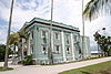 | July 15, 1999 (#99000825) | 201 West Broadway 25°51′27″N 81°23′13″W / 25.8575°N 81.386944°W / 25.8575; -81.386944 (Bank of Everglades Building) | Everglades City | |
| 2 | Bay City Walking Dredge |  | May 29, 2013 (#13000318) | 20200 E. Tamiami Trail 25°59′31″N 81°35′36″W / 25.991839°N 81.593211°W / 25.991839; -81.593211 (Bay City Walking Dredge) | Naples | On display at Collier-Seminole State Park. |
| 3 | Burns Lake Site (8CR259) | Upload image | May 27, 1986 (#86001192) | Address Restricted | Ochopee | |
| 4 | Everglades Laundry | 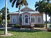 | September 22, 2001 (#01001012) | 105 West Broadway 25°51′24″N 81°23′08″W / 25.856667°N 81.385556°W / 25.856667; -81.385556 (Everglades Laundry) | Everglades City | |
| 5 | Halfway Creek Site | Upload image | August 15, 1980 (#80000365) | Address Restricted | Carnestown | |
| 6 | Hinson Mounds | Upload image | December 29, 1978 (#78000345) | Address Restricted | Miles City | |
| 7 | Capt. John Foley Horr House | 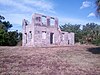 | October 8, 1997 (#97001215) | Northern side of Whiskey Creek Drive 25°54′12″N 81°41′16″W / 25.903333°N 81.687778°W / 25.903333; -81.687778 (Capt. John Foley Horr House) | Key Marco | |
| 8 | Keewaydin Club | 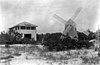 | December 22, 1987 (#87001979) | Northern end of Key Island 26°05′23″N 81°48′02″W / 26.089722°N 81.800556°W / 26.089722; -81.800556 (Keewaydin Club) | Naples | |
| 9 | Naples Historic District |  | December 17, 1987 (#87002179) | Roughly bounded by Ninth Avenue South, Third Street, Thirteenth Avenue South, and the Gulf of Mexico 26°08′00″N 81°48′17″W / 26.133333°N 81.804722°W / 26.133333; -81.804722 (Naples Historic District) | Naples | |
| 10 | Old Collier County Courthouse |  | December 3, 2013 (#13000875) | 102 Copeland Ave., N. 25°51′27″N 81°23′05″W / 25.857582°N 81.384742°W / 25.857582; -81.384742 (Old Collier County Courthouse) | Everglades City | |
| 11 | C. J. Ostl Site | Upload image | December 15, 1978 (#78003380) | Address Restricted | Ochopee | |
| 12 | Palm Cottage |  | May 24, 1982 (#82002371) | 137 12th Avenue, South 26°07′54″N 81°48′15″W / 26.131667°N 81.804167°W / 26.131667; -81.804167 (Palm Cottage) | Naples | |
| 13 | Platt Island |  | December 14, 1978 (#78000934) | Northeast of Miles City off State Road 29[6] 26°12′46″N 81°18′15″W / 26.2128632°N 81.3042421°W / 26.2128632; -81.3042421 (Platt Island) | Miles City | |
| 14 | Plaza Site (8CR303) | Upload image | May 28, 1986 (#86001196) | Address Restricted | Ochopee | |
| 15 | Roberts Ranch |  | October 4, 2003 (#03000990) | 1215 Roberts Avenue 26°25′15″N 81°25′54″W / 26.420833°N 81.431667°W / 26.420833; -81.431667 (Roberts Ranch) | Immokalee | |
| 16 | Seaboard Coast Line Railroad Depot |  | September 10, 1974 (#74000613) | 1051 5th Avenue, South 26°08′33″N 81°47′36″W / 26.1425°N 81.793333°W / 26.1425; -81.793333 (Seaboard Coast Line Railroad Depot) | Naples | |
| 17 | Ted Smallwood Store |  | July 24, 1974 (#74000612) | State Road 29 in Everglades National Park 25°48′34″N 81°21′45″W / 25.809444°N 81.3625°W / 25.809444; -81.3625 (Ted Smallwood Store) | Chokoloskee | |
| 18 | Sugar Pot Site | Upload image | December 15, 1978 (#78000264) | Address Restricted | Ochopee | |
| 19 | Turner River Site | Upload image | December 14, 1978 (#78000263) | Address Restricted | Ochopee |
Former listings
| [3] | Name on the Register | Image | Date listed | Date removed | Location | City or town | Description |
|---|---|---|---|---|---|---|---|
| 1 | Monroe Station (Ochopee, Florida) | 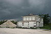 | May 11, 2000 (#00000427) | May 15, 2019 | Junction of the Tamiami Trail and Loop Road 25°51′46″N 81°06′01″W / 25.862778°N 81.100278°W / 25.862778; -81.100278 (Monroe Station (Ochopee, Florida)) | Ochopee | Destroyed by fire[7] |
See also
Wikimedia Commons has media related to National Register of Historic Places in Collier County, Florida.
- List of National Historic Landmarks in Florida
- National Register of Historic Places listings in Florida
References
- ^ The latitude and longitude information provided in this table was derived originally from the National Register Information System, which has been found to be fairly accurate for about 99% of listings. Some locations in this table may have been corrected to current GPS standards.
- ^ National Park Service, United States Department of the Interior, "National Register of Historic Places: Weekly List Actions", retrieved May 10, 2024.
- ^ a b Numbers represent an alphabetical ordering by significant words. Various colorings, defined here, differentiate National Historic Landmarks and historic districts from other NRHP buildings, structures, sites or objects.
- ^ "National Register Information System". National Register of Historic Places. National Park Service. March 13, 2009.
- ^ The eight-digit number below each date is the number assigned to each location in the National Register Information System database, which can be viewed by clicking the number.
- ^ Location derived from its GNIS feature record; the NRIS lists the site as "Address restricted"
- ^ "Photographer Accidentally Burns Down Historic Landmark". 9 May 2016.
- v
- t
- e
by county
- Alachua
- Baker
- Bay
- Bradford
- Brevard
- Broward
- Calhoun
- Charlotte
- Citrus
- Clay
- Collier
- Columbia
- DeSoto
- Dixie
- Duval
- Escambia
- Flagler
- Franklin
- Gadsden
- Gilchrist
- Glades
- Gulf
- Hamilton
- Hardee
- Hendry
- Hernando
- Highlands
- Hillsborough
- Holmes
- Indian River
- Jackson
- Jefferson
- Lake
- Lee
- Leon
- Levy
- Liberty
- Madison
- Manatee
- Marion
- Martin
- Miami-Dade
- Monroe
- Nassau
- Okaloosa
- Okeechobee
- Orange
- Osceola
- Palm Beach
- Pasco
- Pinellas
- Polk
- Putnam
- Santa Rosa
- Sarasota
- Seminole
- St. Johns
- St. Lucie
- Sumter
- Suwannee
- Taylor
- Union
- Volusia
- Wakulla
- Walton
- Washington

Municipalities and communities of Collier County, Florida, United States | ||
|---|---|---|
County seat: East Naples | ||
| Cities |  | |
| CDPs | ||
| Unincorporated communities | ||
| Proposed communities | ||
| Ghost towns | ||
| ||


