National Register of Historic Places listings in Trinity County, California

This is a list of the National Register of Historic Places listings in Trinity County, California.
This is intended to be a complete list of the properties and districts on the National Register of Historic Places in Trinity County, California, United States. Latitude and longitude coordinates are provided for many National Register properties and districts; these locations may be seen together in a Google map.[1]
There are 5 properties and districts listed on the National Register in the county.
This National Park Service list is complete through NPS recent listings posted May 10, 2024.[2]
Map all coordinates using OpenStreetMap
Download coordinates as:
- KML
- GPX (all coordinates)
- GPX (primary coordinates)
- GPX (secondary coordinates)
Current listings
| [3] | Name on the Register[4] | Image | Date listed[5] | Location | City or town | Description |
|---|---|---|---|---|---|---|
| 1 | Bowerman Barn |  | March 20, 1981 (#81000181) | Southwest of Trinity Center on Guy Covington Dr. 40°54′00″N 122°46′01″W / 40.9°N 122.766944°W / 40.9; -122.766944 (Bowerman Barn) | Trinity Center | |
| 2 | De-No-To Cultural District | Upload image | April 24, 1985 (#85000901) | Address Restricted | Onemile Camp | |
| 3 | Helena Historic District | 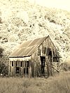 | May 24, 1984 (#84001219) | North of U.S. Route 299, W., on the North Fork of the Trinity River 40°46′29″N 123°07′41″W / 40.774722°N 123.128056°W / 40.774722; -123.128056 (Helena Historic District) | Helena | |
| 4 | Lewiston Historic District |  | April 17, 1989 (#88000550) | Roughly Deadwood, Turnpike, and Schoolhouse Rds. 40°42′30″N 122°48′17″W / 40.708333°N 122.804722°W / 40.708333; -122.804722 (Lewiston Historic District) | Lewiston | |
| 5 | Weaverville Historic District | 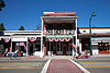 | October 14, 1971 (#71000209) | Both sides of Main St. 40°43′57″N 122°56′22″W / 40.7325°N 122.939444°W / 40.7325; -122.939444 (Weaverville Historic District) | Weaverville |
See also
Wikimedia Commons has media related to National Register of Historic Places in Trinity County, California.
- List of National Historic Landmarks in California
- National Register of Historic Places listings in California
- California Historical Landmarks in Trinity County, California
References
- ^ The latitude and longitude information provided in this table was derived originally from the National Register Information System, which has been found to be fairly accurate for about 99% of listings. Some locations in this table may have been corrected to current GPS standards.
- ^ National Park Service, United States Department of the Interior, "National Register of Historic Places: Weekly List Actions", retrieved May 10, 2024.
- ^ Numbers represent an alphabetical ordering by significant words. Various colorings, defined here, differentiate National Historic Landmarks and historic districts from other NRHP buildings, structures, sites or objects.
- ^ "National Register Information System". National Register of Historic Places. National Park Service. July 9, 2010.
- ^ The eight-digit number below each date is the number assigned to each location in the National Register Information System database, which can be viewed by clicking the number.
- v
- t
- e
- List of U.S. National Historic Landmarks by state:
- Alabama
- Alaska
- Arizona
- Arkansas
- California
- Colorado
- Connecticut
- Delaware
- Florida
- Georgia
- Hawaii
- Idaho
- Illinois
- Indiana
- Iowa
- Kansas
- Kentucky
- Louisiana
- Maine
- Maryland
- Massachusetts
- Michigan
- Minnesota
- Mississippi
- Missouri
- Montana
- Nebraska
- Nevada
- New Hampshire
- New Jersey
- New Mexico
- New York
- North Carolina
- North Dakota
- Ohio
- Oklahoma
- Oregon
- Pennsylvania
- Rhode Island
- South Carolina
- South Dakota
- Tennessee
- Texas
- Utah
- Vermont
- Virginia
- Washington
- West Virginia
- Wisconsin
- Wyoming
 National Register of Historic Places portal
 Category


Municipalities and communities of Trinity County, California, United States | ||
|---|---|---|
County seat: Weaverville | ||
| CDPs |  | |
| Unincorporated communities | ||
| Indian reservation | ||
| Ghost towns | ||
| Footnotes | ‡This populated place also has portions in an adjacent county or counties | |
| ||


