National Register of Historic Places listings in southern Chester County, Pennsylvania


This is a list of the National Register of Historic Places listings in southern Chester County, Pennsylvania.
This is intended to be a complete list of the properties and districts on the National Register of Historic Places in southern Chester County, Pennsylvania. Southern Chester County is defined as being the municipalities south of the Philadelphia Main Line and west of West Chester. The locations of National Register properties and districts, for which the latitude and longitude coordinates are included below, may be seen in a map.[1]
There are 324 properties and districts listed on the Register in Chester County, including 7 National Historic Landmarks. Southern Chester County includes 123 properties and districts, including 2 National Historic Landmarks; the county's remaining properties and districts are listed elsewhere.
This National Park Service list is complete through NPS recent listings posted June 7, 2024.[2]
Map all coordinates using OpenStreetMap
Download coordinates as:
- KML
- GPX (all coordinates)
- GPX (primary coordinates)
- GPX (secondary coordinates)
Current listings
| [3] | Name on the Register | Image | Date listed[4] | Location | Municipality | Description |
|---|---|---|---|---|---|---|
| 1 | John Bailey Farm |  | May 20, 1985 (#85001143) | Springdell Road near Coatesville 39°55′41″N 75°50′28″W / 39.928056°N 75.841111°W / 39.928056; -75.841111 (John Bailey Farm) | East Fallowfield Township | |
| 2 | Baily Farm |  | September 16, 1985 (#85002347) | Strasburg and Broad Run Roads 39°56′55″N 75°42′11″W / 39.948611°N 75.703056°W / 39.948611; -75.703056 (Baily Farm) | West Bradford Township | |
| 3 | Barns-Brinton House |  | May 27, 1971 (#71000692) | East of Hamorton on U.S. Route 1 39°52′24″N 75°37′35″W / 39.873333°N 75.626389°W / 39.873333; -75.626389 (Barns-Brinton House) | Pennsbury Township | |
| 4 | Birmingham Friends Meetinghouse and School |  | July 27, 1971 (#71000688) | 1245 Birmingham Road 39°54′20″N 75°35′42″W / 39.905556°N 75.595°W / 39.905556; -75.595 (Birmingham Friends Meetinghouse and School) | Birmingham Township | |
| 5 | Bradford Friends Meetinghouse |  | July 27, 1971 (#71000694) | Eastern side of Northbrook Road in Marshallton 39°56′54″N 75°40′47″W / 39.948333°N 75.679722°W / 39.948333; -75.679722 (Bradford Friends Meetinghouse) | West Bradford Township | |
| 6 | Brandywine Building and Loan Assoc. Rowhouses |  | May 20, 1985 (#85001144) | Hephzibah Hill Road near Coatesville 39°57′13″N 75°48′24″W / 39.953611°N 75.806667°W / 39.953611; -75.806667 (Brandywine Building and Loan Assoc. Rowhouses) | East Fallowfield Township | |
| 7 | Bridge in East Fallowfield Township | 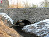 | June 22, 1988 (#88000878) | Strasburg Road over Mill Race near Mortonville 39°56′46″N 75°46′43″W / 39.946111°N 75.778611°W / 39.946111; -75.778611 (Bridge in East Fallowfield Township) | East Fallowfield Township | |
| 8 | Bridge in West Fallowfield Township |  | June 22, 1988 (#88000849) | Ross Fording Road over Octoraro Creek, near Steelville 39°52′58″N 75°59′31″W / 39.882778°N 75.991944°W / 39.882778; -75.991944 (Bridge in West Fallowfield Township) | West Fallowfield Township | |
| 9 | Brinton's Mill |  | May 27, 1971 (#71000689) | North of Chadds Ford on Creek Road 39°53′07″N 75°36′13″W / 39.885278°N 75.603611°W / 39.885278; -75.603611 (Brinton's Mill) | Birmingham Township | |
| 10 | Edward Brinton House |  | June 19, 1973 (#73001599) | Northwest of Chadds Ford at 1325 Creek Road 39°53′17″N 75°36′29″W / 39.888056°N 75.608056°W / 39.888056; -75.608056 (Edward Brinton House) | Birmingham Township | |
| 11 | George Brinton House |  | October 25, 1990 (#90001608) | Pennsylvania Route 100, 1 mile north of its junction with U.S. Route 1, near Chadds Ford 39°52′51″N 75°35′56″W / 39.880833°N 75.598889°W / 39.880833; -75.598889 (George Brinton House) | Birmingham Township | |
| 12 | Brinton-King Farmstead |  | March 21, 2002 (#02000230) | 1301 Brinton's Bridge Road, 162 Baltimore Pike 39°52′29″N 75°37′13″W / 39.874597°N 75.620275°W / 39.874597; -75.620275 (Brinton-King Farmstead) | Pennsbury Township | |
| 13 | Brooklawn |  | January 24, 2022 (#100006433) | 1825 Newark Rd. 39°53′50″N 75°46′53″W / 39.8971°N 75.7814°W / 39.8971; -75.7814 (Brooklawn) | West Marlborough Township | |
| 14 | Carter-Worth House and Farm |  | September 15, 1977 (#77001151) | 450 Lucky Hill Road near Marshallton 39°56′43″N 75°40′02″W / 39.945278°N 75.667222°W / 39.945278; -75.667222 (Carter-Worth House and Farm) | East Bradford Township | |
| 15 | Cedarcroft |  | November 11, 1971 (#71000693) | North of Kennett Square 39°51′35″N 75°43′09″W / 39.859722°N 75.719167°W / 39.859722; -75.719167 (Cedarcroft) | East Marlborough Township | |
| 16 | Chandler Mill Bridge | 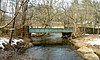 | January 11, 2010 (#09001213) | Chandler Mill Road over West Branch Red Clay Creek 39°48′41″N 75°42′48″W / 39.811389°N 75.713417°W / 39.811389; -75.713417 (Chandler Mill Bridge) | Kennett Township | |
| 17 | Como Farm |  | September 16, 1985 (#85002348) | Broad Run Road 39°57′08″N 75°42′26″W / 39.952222°N 75.707222°W / 39.952222; -75.707222 (Como Farm) | West Bradford Township | |
| 18 | Cope's Bridge |  | March 7, 1985 (#85000465) | Strasburg Road (Pennsylvania Route 162) west of its junction with Creek Road and east of Marshallton[5] 39°57′32″N 75°39′19″W / 39.958861°N 75.655361°W / 39.958861; -75.655361 (Cope's Bridge) | West Bradford Township | |
| 19 | Daniel Davis House and Barn |  | April 11, 1973 (#73001598) | Birmingham and Street Road 39°54′47″N 75°36′00″W / 39.913056°N 75.6°W / 39.913056; -75.6 (Daniel Davis House and Barn) | Birmingham Township | |
| 20 | Delaware Boundary Markers | Upload image | February 18, 1975 (#75002101) | Boundary line dividing Delaware from Maryland and Pennsylvania Coordinates missing | Multiple | Extends into Delaware and eastern Maryland. |
| 21 | Harry DeHaven House |  | September 18, 1985 (#85002386) | Strasburg Road near Coatesville 39°57′21″N 75°50′53″W / 39.955891°N 75.847956°W / 39.955891; -75.847956 (Harry DeHaven House) | East Fallowfield Township | |
| 22 | Derbydown Homestead |  | February 4, 1973 (#73001609) | At the junction of CR 15077 and 15080 39°55′31″N 75°41′12″W / 39.925278°N 75.686667°W / 39.925278; -75.686667 (Derbydown Homestead) | West Bradford Township | |
| 23 | Dilworthtown Historic District |  | January 18, 1973 (#73001601) | Junction of CR 15199 and 15087 39°53′57″N 75°34′06″W / 39.899167°N 75.568333°W / 39.899167; -75.568333 (Dilworthtown Historic District) | Birmingham Township | |
| 24 | Doe Run Village Historic District |  | September 16, 1985 (#85002349) | Highland Dairy, DuPont & Chapel Roads, and Pennsylvania Routes 82 and 841 39°55′08″N 75°49′04″W / 39.918889°N 75.817778°W / 39.918889; -75.817778 (Doe Run Village Historic District) | West Marlborough Township | |
| 25 | Edward Dougherty House |  | May 20, 1985 (#85001145) | Mt. Carmel Road near Coatesville 39°57′45″N 75°51′43″W / 39.9625°N 75.861944°W / 39.9625; -75.861944 (Edward Dougherty House) | East Fallowfield Township | |
| 26 | Philip Dougherty House |  | September 18, 1985 (#85002390) | Strasburg Road near Coatesville 39°57′32″N 75°52′20″W / 39.958889°N 75.872222°W / 39.958889; -75.872222 (Philip Dougherty House) | East Fallowfield Township | |
| 27 | Philip Dougherty Tavern |  | September 18, 1985 (#85002391) | Strasburg Road near Coatesville 39°57′40″N 75°51′42″W / 39.961111°N 75.861667°W / 39.961111; -75.861667 (Philip Dougherty Tavern) | East Fallowfield Township | |
| 28 | Drovers Inn |  | September 18, 1985 (#85002388) | Strasburg Road near Coatesville 39°57′14″N 75°50′18″W / 39.953889°N 75.838333°W / 39.953889; -75.838333 (Drovers Inn) | East Fallowfield Township | |
| 29 | East Bradford Boarding School for Boys |  | March 7, 1973 (#73001605) | 1 mile (1.6 km) east of Lenape at West Chester and Sconnelltown Roads 39°55′47″N 75°37′07″W / 39.929722°N 75.618611°W / 39.929722; -75.618611 (East Bradford Boarding School for Boys) | East Bradford Township | |
| 30 | Edgewood |  | March 7, 1973 (#09000102) | Southeast of the junction of County Roads 15087 and 15221, near West Chester 39°54′08″N 75°35′21″W / 39.902333°N 75.589167°W / 39.902333; -75.589167 (Edgewood) | Birmingham Township | |
| 31 | Embreeville Historic District |  | September 16, 1985 (#85002350) | Pennsylvania Route 162 39°55′35″N 75°43′55″W / 39.926389°N 75.731944°W / 39.926389; -75.731944 (Embreeville Historic District) | Newlin Township | |
| 32 | Ercildoun Historic District |  | May 20, 1985 (#85001157) | Pennsylvania Route 82, Township 368, Legislative Route 15236, and Township 371 and 182 39°56′35″N 75°50′31″W / 39.943056°N 75.841944°W / 39.943056; -75.841944 (Ercildoun Historic District) | East Fallowfield Township | |
| 33 | Fairville Historic District |  | November 7, 1996 (#96001200) | Kennett Pike between Fairville Road and Hickory Hill Road 39°50′52″N 75°38′00″W / 39.847778°N 75.633333°W / 39.847778; -75.633333 (Fairville Historic District) | Pennsbury Township | |
| 34 | John Ferron House |  | November 26, 1985 (#85003049) | Saint Malachi Road 39°53′57″N 75°51′06″W / 39.899167°N 75.851667°W / 39.899167; -75.851667 (John Ferron House) | Londonderry Township | |
| 35 | Gibson's Covered Bridge |  | December 10, 1980 (#80003456) | Southeast of Downingtown on Township 391 39°58′34″N 75°41′00″W / 39.976111°N 75.683333°W / 39.976111; -75.683333 (Gibson's Covered Bridge) | East and West Bradford Townships | |
| 36 | Joseph Gladden House |  | May 20, 1985 (#85001146) | West Chester Road near Coatesville 39°58′45″N 75°47′29″W / 39.979167°N 75.791389°W / 39.979167; -75.791389 (Joseph Gladden House) | East Fallowfield Township | |
| 37 | Glen Hope Covered Bridge |  | December 10, 1980 (#80003472) | West of Lewisville on Township 344, near West Grove 39°43′37″N 75°54′28″W / 39.726944°N 75.907778°W / 39.726944; -75.907778 (Glen Hope Covered Bridge) | Elk Township | |
| 38 | Glen Rose Historic District |  | September 18, 1985 (#85002384) | Legislative Route 15178 and Township 371 39°56′37″N 75°51′33″W / 39.943611°N 75.859167°W / 39.943611; -75.859167 (Glen Rose Historic District) | East Fallowfield Township | |
| 39 | Green Valley Historic District |  | September 16, 1985 (#85002352) | Green Valley Road 39°55′18″N 75°45′40″W / 39.921667°N 75.761111°W / 39.921667; -75.761111 (Green Valley Historic District) | East Marlborough and Newlin Townships | |
| 40 | Joseph Gregg House |  | February 4, 1994 (#94000007) | 500 Chandler Mill Road 39°49′05″N 75°43′07″W / 39.818056°N 75.718611°W / 39.818056; -75.718611 (Joseph Gregg House) | Kennett Township | |
| 41 | Hamorton Historic District |  | April 26, 1990 (#90000704) | Junction of U.S. Route 1 and Pennsylvania Route 52 39°52′08″N 75°39′18″W / 39.868889°N 75.655°W / 39.868889; -75.655 (Hamorton Historic District) | Kennett Township | |
| 42 | Hance House and Barn |  | September 16, 1985 (#85002354) | 15 S Bridge Rd. (Pennsylvania Route 842) 39°55′39″N 75°39′12″W / 39.9275°N 75.653333°W / 39.9275; -75.653333 (Hance House and Barn) | East Bradford Township | |
| 43 | John Hanna Farm |  | May 20, 1985 (#85001147) | Fairview Road near Coatesville 39°56′11″N 75°47′42″W / 39.936389°N 75.795°W / 39.936389; -75.795 (John Hanna Farm) | East Fallowfield Township | |
| 44 | Col. John Hannum House |  | December 10, 1980 (#80003463) | Northeast of Marshallton at 898 Frank Road 39°58′06″N 75°39′34″W / 39.968439°N 75.659461°W / 39.968439; -75.659461 (Col. John Hannum House) | East Bradford Township | |
| 45 | Harlan House |  | May 9, 1985 (#85001004) | Pennsylvania Route 162 and Star Gazer Road, near Embreeville 39°56′17″N 75°43′56″W / 39.938056°N 75.732222°W / 39.938056; -75.732222 (Harlan House) | Newlin Township | |
| 46 | Harlan Log House |  | July 16, 1987 (#87001211) | Fairville Road near Kennett Square 39°50′25″N 75°38′14″W / 39.840278°N 75.637222°W / 39.840278; -75.637222 (Harlan Log House) | Kennett Township | |
| 47 | Peter Harvey House and Barn |  | April 20, 1978 (#78002371) | East of Kennett Square on Hillendale Road near Mendenhall 39°51′54″N 75°37′26″W / 39.865°N 75.623889°W / 39.865; -75.623889 (Peter Harvey House and Barn) | Pennsbury Township | |
| 48 | William Harvey House |  | May 27, 1971 (#71000690) | Northwest of Chadds Ford on Brinton's Bridge Road off U.S. Route 1 39°52′35″N 75°37′04″W / 39.876389°N 75.617778°W / 39.876389; -75.617778 (William Harvey House) | Pennsbury Township | |
| 49 | Hayes Homestead |  | September 16, 1985 (#85002355) | Pennsylvania Route 162 and Harvey's Bridge Road 39°56′09″N 75°44′10″W / 39.935833°N 75.736111°W / 39.935833; -75.736111 (Hayes Homestead) | Newlin Township | |
| 50 | Hayes Mill House |  | September 16, 1985 (#85002358) | Star Gazer Road 39°56′23″N 75°44′01″W / 39.939722°N 75.733611°W / 39.939722; -75.733611 (Hayes Mill House) | Newlin Township | |
| 51 | Jacob Hayes House |  | September 16, 1985 (#85002356) | Pennsylvania Route 162 39°56′09″N 75°44′07″W / 39.935833°N 75.735278°W / 39.935833; -75.735278 (Jacob Hayes House) | Newlin Township | |
| 52 | Cyrus Hoopes House and Barn |  | November 26, 1985 (#85003050) | Springdell Road 39°54′33″N 75°49′59″W / 39.909167°N 75.833056°W / 39.909167; -75.833056 (Cyrus Hoopes House and Barn) | West Marlborough Township | |
| 53 | Hopewell Historic District |  | February 28, 1991 (#91000226) | Roughly Hopewell Road from Lower Hopewell Road to Roneys Corner Road and area south, and Lower Hopewell Road north past Calvery Road 39°46′46″N 76°01′01″W / 39.779444°N 76.016944°W / 39.779444; -76.016944 (Hopewell Historic District) | East Nottingham and Lower Oxford Townships | |
| 54 | Hosanna Church and Cemetery | Upload image | March 25, 2024 (#100010101) | 531 University Road 39°48′41″N 75°55′31″W / 39.8113°N 75.9254°W / 39.8113; -75.9254 (Hosanna Church and Cemetery) | Upper Oxford Township | |
| 55 | House at Springdell |  | September 16, 1985 (#85002360) | Pennsylvania Route 841 39°54′25″N 75°50′09″W / 39.906944°N 75.835833°W / 39.906944; -75.835833 (House at Springdell) | West Marlborough Township | |
| 56 | House at Upper Laurel Iron Works |  | September 16, 1985 (#85002371) | McCorkel's Rock Road 39°56′00″N 75°46′47″W / 39.933333°N 75.779722°W / 39.933333; -75.779722 (House at Upper Laurel Iron Works) | Newlin Township | |
| 57 | Indian Deep Farm |  | September 16, 1985 (#85002372) | Glenhall and Groundhog College Roads 39°55′34″N 75°41′59″W / 39.926111°N 75.699722°W / 39.926111; -75.699722 (Indian Deep Farm) | Newlin Township | |
| 58 | Kennett Square Historic District |  | August 18, 1989 (#89001052) | Roughly bounded by Sickles, Willow, Mulberry, Broad, South, Union, Cedar, Lafayette, State, and Washington 39°50′41″N 75°42′44″W / 39.844722°N 75.712222°W / 39.844722; -75.712222 (Kennett Square Historic District) | Kennett Square | |
| 59 | Lenape Bridge |  | June 22, 1988 (#88000781) | Pennsylvania Route 52 over parking lot 39°54′54″N 75°37′47″W / 39.915°N 75.629722°W / 39.915; -75.629722 (Lenape Bridge) | Birmingham and Pocopson Townships | |
| 60 | Lincoln University |  | June 13, 2022 (#100007786) | 1570 Baltimore Pike 39°48′34″N 75°55′53″W / 39.8095°N 75.9314°W / 39.8095; -75.9314 (Lincoln University) | Lower Oxford Township | |
| 61 | Longwood Gardens District |  | December 10, 1972 (#72001105) | On U.S. Route 1 near Hamorton 39°52′11″N 75°40′43″W / 39.869722°N 75.678611°W / 39.869722; -75.678611 (Longwood Gardens District) | East Marlborough Township | |
| 62 | Lunn's Tavern |  | October 25, 1979 (#79002204) | Pennsylvania Route 896 at Strickersville 39°44′06″N 75°47′38″W / 39.735°N 75.793889°W / 39.735; -75.793889 (Lunn's Tavern) | London Britain Township | |
| 63 | Marlborough Village Historic District |  | March 8, 1995 (#95000130) | 354–418 Marlborough Road and 901 and 940 Marlborough Springs Road, near Kennett Square 39°54′00″N 75°42′11″W / 39.9°N 75.703056°W / 39.9; -75.703056 (Marlborough Village Historic District) | East Marlborough and Newlin Townships | |
| 64 | Humphry Marshall House |  | May 27, 1971 (#71000695) | Strasburg Road / Pennsylvania Route 162 at the junction with Northbrook Road, near Marshallton 39°57′02″N 75°40′54″W / 39.950556°N 75.681667°W / 39.950556; -75.681667 (Humphry Marshall House) | West Bradford Township | |
| 65 | Marshallton Historic District |  | January 8, 1986 (#86000056) | Strasburg Road in Marshallton 39°57′00″N 75°40′35″W / 39.95°N 75.676389°W / 39.95; -75.676389 (Marshallton Historic District) | West Bradford Township | |
| 66 | Marshallton Inn |  | July 29, 1977 (#77001152) | West Strasburg Road in Marshallton 39°57′01″N 75°40′43″W / 39.950278°N 75.678611°W / 39.950278; -75.678611 (Marshallton Inn) | West Bradford Township | |
| 67 | Mercer's Mill Covered Bridge |  | December 11, 1980 (#80003509) | Northeast of Christiana and south of Atglen 39°55′53″N 75°58′54″W / 39.931389°N 75.981667°W / 39.931389; -75.981667 (Mercer's Mill Covered Bridge) | West Fallowfield Township | Extends into Lancaster County |
| 68 | Merestone |  | March 2, 1995 (#95000093) | Yeatman's Station Rd. 39°45′45″N 75°44′57″W / 39.7625°N 75.749167°W / 39.7625; -75.749167 (Merestone) | New Garden Township | Extends into northern New Castle County, Delaware |
| 69 | Mortonville Hotel | 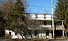 | September 18, 1985 (#85002393) | Strasburg Road near Coatesville 39°56′49″N 75°46′41″W / 39.946944°N 75.778056°W / 39.946944; -75.778056 (Mortonville Hotel) | East Fallowfield Township | |
| 70 | Mountain Meadow Farm |  | September 16, 1985 (#85002373) | Harvey's Bridge Road 39°56′00″N 75°44′48″W / 39.933333°N 75.746667°W / 39.933333; -75.746667 (Mountain Meadow Farm) | Newlin Township | |
| 71 | Northbrook Historic District |  | September 16, 1985 (#85002374) | Northbrook, Indian Hannah, and Bragg Hill Roads 39°55′19″N 75°41′29″W / 39.921944°N 75.691389°W / 39.921944; -75.691389 (Northbrook Historic District) | Newlin, Pocopson, and West Bradford Townships | |
| 72 | Oakdale |  | January 13, 1972 (#72001103) | Hillendale Road near Chadds Ford 39°51′39″N 75°37′18″W / 39.860833°N 75.621667°W / 39.860833; -75.621667 (Oakdale) | Pennsbury Township | |
| 73 | Old Kennett Meetinghouse |  | July 15, 1974 (#74001776) | South of West Chester on U.S. Route 1, east of its junction with Pennsylvania Route 52 39°52′16″N 75°38′54″W / 39.871111°N 75.648333°W / 39.871111; -75.648333 (Old Kennett Meetinghouse) | Kennett Township | |
| 74 | Orthodox Meetinghouse |  | April 26, 1972 (#72001112) | Southwest of West Chester on Birmingham Road 39°54′16″N 75°35′38″W / 39.904444°N 75.593889°W / 39.904444; -75.593889 (Orthodox Meetinghouse) | Birmingham Township | |
| 75 | Oxford Historic District | 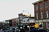 | February 1, 2007 (#06001336) | Roughly bounded by Church Road, Chase Street, Hodgson Street 39°47′07″N 75°58′44″W / 39.785386°N 75.978836°W / 39.785386; -75.978836 (Oxford Historic District) | Oxford | |
| 76 | Oxford Hotel |  | August 26, 1994 (#94001055) | Junction of Market and North 3rd Streets 39°47′07″N 75°58′44″W / 39.785278°N 75.978889°W / 39.785278; -75.978889 (Oxford Hotel) | Oxford | |
| 77 | Paradise Valley Historic District |  | December 24, 1992 (#92001724) | Roughly Valley Creek Road from U.S. Route 322 to Ravine Road, near Marshallton 39°59′04″N 75°39′55″W / 39.984444°N 75.665278°W / 39.984444; -75.665278 (Paradise Valley Historic District) | East Bradford Township | |
| 78 | Parkersville Friends Meetinghouse |  | March 20, 1973 (#73001610) | South of Parkersville off Pennsylvania Route 926 39°53′10″N 75°38′44″W / 39.886111°N 75.645556°W / 39.886111; -75.645556 (Parkersville Friends Meetinghouse) | Pennsbury Township | |
| 79 | Mansel Passmore House |  | May 20, 1985 (#85001148) | Glen Rose Road near Coatesville 39°56′25″N 75°51′06″W / 39.940278°N 75.851667°W / 39.940278; -75.851667 (Mansel Passmore House) | East Fallowfield Township | |
| 80 | Isaac Pawling House |  | September 18, 1985 (#85002394) | Strasburg Road near Coatesville 39°57′18″N 75°50′53″W / 39.955128°N 75.848017°W / 39.955128; -75.848017 (Isaac Pawling House) | East Fallowfield Township | |
| 81 | Martha Pennock House |  | May 20, 1985 (#85001149) | Pennsylvania Route 82 near Coatesville 39°55′59″N 75°49′57″W / 39.933056°N 75.8325°W / 39.933056; -75.8325 (Martha Pennock House) | East Fallowfield Township | |
| 82 | Pennsbury Inn | 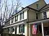 | March 16, 1972 (#72001104) | On U.S. Route 1 at its junction with Hickory Hill Road, near Chadds Ford 39°52′29″N 75°38′13″W / 39.874722°N 75.636944°W / 39.874722; -75.636944 (Pennsbury Inn) | Pennsbury Township | |
| 83 | William Peters House |  | May 27, 1971 (#71000696) | Hillendale Road near Mendenhall 39°51′50″N 75°37′36″W / 39.863889°N 75.626667°W / 39.863889; -75.626667 (William Peters House) | Pennsbury Township | |
| 84 | Joseph and Esther Phillips Plantation |  | September 5, 1990 (#90001414) | Bailey's Crossroads, south of Glen Run Road and south of Atglen 39°55′36″N 75°58′25″W / 39.926667°N 75.973611°W / 39.926667; -75.973611 (Joseph and Esther Phillips Plantation) | West Fallowfield Township | |
| 85 | Lukens Pierce House |  | March 14, 1973 (#73001604) | Northwest of Ercildoun on Wilmington Road 39°57′09″N 75°51′00″W / 39.9525°N 75.85°W / 39.9525; -75.85 (Lukens Pierce House) | East Fallowfield Township | |
| 86 | Pine Grove Covered Bridge |  | December 11, 1980 (#80003521) | Southeast of Kirkwood on Legislative Route 36018 39°47′37″N 76°02′41″W / 39.793611°N 76.044722°W / 39.793611; -76.044722 (Pine Grove Covered Bridge) | East Nottingham Township | Extends into Lancaster County |
| 87 | Powell Farm |  | August 20, 1985 (#85001150) | Dupont Road near Coatesville 39°56′13″N 75°48′29″W / 39.936944°N 75.808056°W / 39.936944; -75.808056 (Powell Farm) | East Fallowfield Township | |
| 88 | John Powell House |  | May 20, 1985 (#85001151) | Hephzibah Hill Road near Coatesville 39°56′16″N 75°48′50″W / 39.937778°N 75.813889°W / 39.937778; -75.813889 (John Powell House) | East Fallowfield Township | |
| 89 | Primitive Hall |  | March 19, 1975 (#75001629) | 2 miles (3.2 km) northwest of Chatham on Pennsylvania Route 841 39°52′33″N 75°50′02″W / 39.875833°N 75.833889°W / 39.875833; -75.833889 (Primitive Hall) | West Marlborough Township | |
| 90 | Joshua Pusey House | 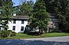 | May 20, 1985 (#85001152) | Saw Mill Road near Coatesville 39°57′24″N 75°46′47″W / 39.956667°N 75.779722°W / 39.956667; -75.779722 (Joshua Pusey House) | East Fallowfield Township | |
| 91 | Moses Ross House |  | September 16, 1985 (#85002375) | Off Creek Road north of Daleville 39°53′45″N 75°52′21″W / 39.895833°N 75.8725°W / 39.895833; -75.8725 (Moses Ross House) | Londonderry Township | |
| 92 | St. Malachi Church |  | September 16, 1985 (#85002376) | St. Malachi Road 39°53′48″N 75°50′57″W / 39.896667°N 75.849167°W / 39.896667; -75.849167 (St. Malachi Church) | Londonderry Township | |
| 93 | David Scott House |  | May 20, 1985 (#85001153) | Mt. Carmel Road near Coatesville 39°57′35″N 75°51′41″W / 39.959722°N 75.861389°W / 39.959722; -75.861389 (David Scott House) | East Fallowfield Township | |
| 94 | Thomas Scott House |  | May 20, 1985 (#85001154) | Park Avenue near Coatesville 39°57′55″N 75°51′09″W / 39.965278°N 75.8525°W / 39.965278; -75.8525 (Thomas Scott House) | East Fallowfield Township | |
| 95 | Sharpless Homestead |  | December 15, 2011 (#11000924) | 1045 Birmingham Rd. 39°55′08″N 75°36′22″W / 39.918861°N 75.605995°W / 39.918861; -75.605995 (Sharpless Homestead) | Birmingham Township | |
| 96 | South Brook Farm |  | November 14, 1991 (#91001710) | Junction of Street Road and Bird Road 39°52′00″N 75°45′13″W / 39.866667°N 75.753611°W / 39.866667; -75.753611 (South Brook Farm) | East Marlborough Township | |
| 97 | Speakman No. 1 |  | December 10, 1980 (#80003464) | South of Coatesville on Legislative Route 15068, near Modena 39°55′46″N 75°49′23″W / 39.929444°N 75.823056°W / 39.929444; -75.823056 (Speakman No. 1) | East Fallowfield Township | |
| 98 | Speakman No. 2, Mary Ann Pyle Bridge | 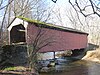 | December 10, 1980 (#80003465) | South of Coatesville on Township 371, near Modena 39°55′19″N 75°48′01″W / 39.921944°N 75.800278°W / 39.921944; -75.800278 (Speakman No. 2, Mary Ann Pyle Bridge) | East Fallowfield Township | |
| 99 | Springdale Farm |  | March 7, 1973 (#73001607) | Northeast of Mendenhall on Hillendale Road 39°51′39″N 75°37′45″W / 39.860833°N 75.629167°W / 39.860833; -75.629167 (Springdale Farm) | Pennsbury Township | |
| 100 | Spruce Grove School |  | September 16, 1985 (#85002378) | Brandywine Creek Road 39°56′07″N 75°46′08″W / 39.935278°N 75.768889°W / 39.935278; -75.768889 (Spruce Grove School) | Newlin Township | |
| 101 | Robert Steen House |  | May 20, 1985 (#85001155) | Fairview Road near Coatesville 39°56′28″N 75°47′16″W / 39.941111°N 75.787778°W / 39.941111; -75.787778 (Robert Steen House) | East Fallowfield Township | |
| 102 | Linton Stephens Covered Bridge |  | December 10, 1980 (#80003466) | Southwest of New London on Township 344 39°45′23″N 75°54′46″W / 39.756389°N 75.912778°W / 39.756389; -75.912778 (Linton Stephens Covered Bridge) | Elk and New London Townships | |
| 103 | Strode's Mill |  | May 27, 1971 (#71000697) | Junction of Pennsylvania Route 52 and Birmingham Road 39°55′43″N 75°37′04″W / 39.928611°N 75.617778°W / 39.928611; -75.617778 (Strode's Mill) | East Bradford Township | |
| 104 | Strode's Mill Historic District |  | May 5, 1989 (#89000354) | Junction of Pennsylvania Route 52 and Birmingham Road 39°55′42″N 75°37′03″W / 39.928333°N 75.6175°W / 39.928333; -75.6175 (Strode's Mill Historic District) | East Bradford Township | |
| 105 | Taylor House |  | August 1, 1979 (#79002202) | East of Marshallton on West Strasburg Road 39°57′27″N 75°39′40″W / 39.9575°N 75.661111°W / 39.9575; -75.661111 (Taylor House) | East Bradford Township | |
| 106 | Taylor-Cope Historic District |  | July 16, 1987 (#87001250) | 890–1100 blocks of Strasburg Road/Pennsylvania Route 162 in Marshallton 39°57′32″N 75°38′50″W / 39.958889°N 75.647222°W / 39.958889; -75.647222 (Taylor-Cope Historic District) | West Bradford Township | |
| 107 | Temple-Webster-Stoner House |  | March 7, 1973 (#72133612) | East of Romansville off Pennsylvania Route 162 39°56′42″N 75°42′05″W / 39.945°N 75.701389°W / 39.945; -75.701389 (Temple-Webster-Stoner House) | West Bradford Township | |
| 108 | Thompson Farm |  | July 14, 1983 (#83002228) | 632 Chambers Rock Road near New London 39°43′54″N 75°46′57″W / 39.731667°N 75.7825°W / 39.731667; -75.7825 (Thompson Farm) | London Britain Township | |
| 109 | Trimbleville Historic District |  | September 16, 1985 (#85002377) | Northbrook, Broad Run, and Camp Linden Roads 39°55′55″N 75°40′56″W / 39.931944°N 75.682222°W / 39.931944; -75.682222 (Trimbleville Historic District) | Pocopson and West Bradford Townships | |
| 110 | Twin Bridges Rural Historic District |  | September 18, 2017 (#100001635) | Roughly bounded by Creek and Bullock Rds., the Beverly Farm, Big Bend, and Hill Girt Farms estates, and Brandywine Creek 39°50′54″N 75°36′09″W / 39.848333°N 75.602500°W / 39.848333; -75.602500 (Twin Bridges Rural Historic District) | Pennsbury Township | Extends into Chadds Ford Township in Delaware County |
| 111 | Unionville Village Historic District |  | June 6, 1979 (#79002205) | Pennsylvania Routes 82 and 162, at Unionville 39°53′42″N 75°44′09″W / 39.895°N 75.735833°W / 39.895; -75.735833 (Unionville Village Historic District) | East Marlborough Township | |
| 112 | Rev. Joshua Vaughan House |  | September 18, 1985 (#85002395) | Strasburg Road near Coatesville 39°57′03″N 75°48′54″W / 39.950833°N 75.815°W / 39.950833; -75.815 (Rev. Joshua Vaughan House) | East Fallowfield Township | |
| 113 | Asa Walton House |  | September 18, 1985 (#85002396) | Strasburg and Old Wilmington Roads, near Coatesville 39°57′20″N 75°51′16″W / 39.955556°N 75.854444°W / 39.955556; -75.854444 (Asa Walton House) | East Fallowfield Township | |
| 114 | John Wentz House |  | May 20, 1985 (#85001156) | Pennsylvania Route 82 near Coatesville 39°56′40″N 75°49′59″W / 39.944444°N 75.833056°W / 39.944444; -75.833056 (John Wentz House) | East Fallowfield Township | |
| 115 | White Horse Tavern |  | September 18, 1985 (#85002397) | Strasburg Road near Coatesville 39°57′02″N 75°49′11″W / 39.950556°N 75.819722°W / 39.950556; -75.819722 (White Horse Tavern) | East Fallowfield Township | |
| 116 | Gideon Wickersham Farmstead |  | January 30, 1988 (#87001992) | 750 Northbrook Road near Kennett Square 39°53′19″N 75°41′23″W / 39.888611°N 75.689722°W / 39.888611; -75.689722 (Gideon Wickersham Farmstead) | East Marlborough Township | |
| 117 | Wiley-Cloud House |  | September 4, 2012 (#12000606) | 107 Ironstone Ln. 39°49′51″N 75°40′19″W / 39.830879°N 75.671867°W / 39.830879; -75.671867 (Wiley-Cloud House) | Kennett Township | |
| 118 | Wilkinson House |  | September 16, 1985 (#85002379) | Pennsylvania Route 842 39°55′33″N 75°39′57″W / 39.925833°N 75.665833°W / 39.925833; -75.665833 (Wilkinson House) | Pocopson Township | |
| 119 | Robert Wilson House |  | September 18, 1985 (#85002398) | Strasburg Road near Coatesville 39°57′09″N 75°50′32″W / 39.9525°N 75.842222°W / 39.9525; -75.842222 (Robert Wilson House) | East Fallowfield Township | |
| 120 | Worker's House at Lower Laurel Iron Works |  | September 16, 1985 (#85002381) | Creek Road 39°56′14″N 75°46′08″W / 39.937222°N 75.768889°W / 39.937222; -75.768889 (Worker's House at Lower Laurel Iron Works) | Newlin Township | |
| 121 | Worth-Jefferis Rural Historic District |  | April 27, 1995 (#95000523) | Roughly along Lucky Hill, North Wawaset, Allerton, and Creek Roads, near Marshallton 39°56′15″N 75°39′13″W / 39.9375°N 75.653611°W / 39.9375; -75.653611 (Worth-Jefferis Rural Historic District) | East and West Bradford Townships | |
| 122 | Joseph Young House |  | September 16, 1985 (#85002383) | Creek Road 39°56′12″N 75°45′39″W / 39.936667°N 75.760833°W / 39.936667; -75.760833 (Joseph Young House) | Newlin Township | |
| 123 | Robert Young House |  | September 18, 1985 (#85002399) | Strasburg Road near Coatesville 39°57′02″N 75°49′13″W / 39.950556°N 75.820278°W / 39.950556; -75.820278 (Robert Young House) | East Fallowfield Township |
Former listings
| [3] | Name on the Register | Image | Date listed | Date removed | Location | Municipality | Description |
|---|---|---|---|---|---|---|---|
| 1 | Bridge in New Garden Township | 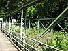 | June 22, 1988 (#88000804) | March 23, 2010 | Landenberg Road over White Clay Creek, near Landenberg 39°46′39″N 75°46′19″W / 39.7775°N 75.7719°W / 39.7775; -75.7719 (Bridge in New Garden Township) | New Garden Township | Delisted due to alterations made to the bridge during replacement in 2010. |
| 2 | Mortonville Bridge |  | September 18, 1985 (#85002392) | July 16, 2010 | Strasburg Road near Coatesville 39°56′47″N 75°46′47″W / 39.9464°N 75.7797°W / 39.9464; -75.7797 (Mortonville Bridge) | East Fallowfield Township and Newlin Township | Delisted due to alterations made to the bridge during rehabilitation and expansion in 2010. |
| 3 | Rudolph and Arthur Covered Bridge |  | December 10, 1980 (#80003473) | December 12, 2022 | North of Lewisville on Township 307 near West Grove 39°44′45″N 75°52′57″W / 39.745833°N 75.8825°W / 39.745833; -75.8825 (Rudolph and Arthur Covered Bridge) | Elk and New London Townships | Destroyed September 1, 2021 by flooding from Hurricane Ida |
References
- ^ The latitude and longitude information provided in this table was derived originally from the National Register Information System, which has been found to be fairly accurate for about 99% of listings. Some locations in this table may have been corrected to current GPS standards.
- ^ National Park Service, United States Department of the Interior, "National Register of Historic Places: Weekly List Actions", retrieved June 7, 2024.
- ^ a b Numbers represent an alphabetical ordering by significant words. Various colorings, defined here, differentiate National Historic Landmarks and historic districts from other NRHP buildings, structures, sites or objects.
- ^ The eight-digit number below each date is the number assigned to each location in the National Register Information System database, which can be viewed by clicking the number.
- ^ Location derived from its NRHP nomination form; the NRIS lists the site as "Address Restricted"
- v
- t
- e

- Adams
- Allegheny
- Armstrong
- Beaver
- Bedford
- Berks
- Blair
- Bradford
- Bucks
- Butler
- Cambria
- Cameron
- Carbon
- Centre
- Chester
- Clarion
- Clearfield
- Clinton
- Columbia
- Crawford
- Cumberland
- Dauphin
- Delaware
- Elk
- Erie
- Fayette
- Forest
- Franklin
- Fulton
- Greene
- Huntingdon
- Indiana
- Jefferson
- Juniata
- Lackawanna
- Lancaster
- Lawrence
- Lebanon
- Lehigh
- Luzerne
- Lycoming
- McKean
- Mercer
- Mifflin
- Monroe
- Montgomery
- Montour
- Northampton
- Northumberland
- Perry
- Philadelphia
- Pike
- Potter
- Schuylkill
- Snyder
- Somerset
- Sullivan
- Susquehanna
- Tioga
- Union
- Venango
- Warren
- Washington
- Wayne
- Westmoreland
- Wyoming
- York
 Category
 NRHP portal


