Point La Nim, New Brunswick
Local Service District in New Brunswick, Canada
48°04′N 66°27′W / 48.06°N 66.45°W / 48.06; -66.45 Canada
 New Brunswick
Federal
Madawaska—Restigouche
(2016)
 10.81%
 Route 134
- Median household income, 2015 (all households)
Point La Nim (2016 pop. 231) is an unincorporated community and former local service district in Restigouche County, New Brunswick, Canada.[1][2]
The community is located on the Restigouche River immediately upstream (west) from the town of Dalhousie. Its name was taken from Mi'kmaq name "ananimkik" which translates to "lookout place". Located west of Dalhousie. Point La Nim's post office was originally called "Point La Nin" in 1855. It was renamed Point La Nim in 1862.
History
Notable people
See also
References
-
 Point La Nim / Restigouche River - summer
 -
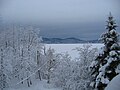 Point La Nim / Restigouche River - winter


Places adjacent to Point La Nim, New Brunswick | ||||||||||||||||
|---|---|---|---|---|---|---|---|---|---|---|---|---|---|---|---|---|
| ||||||||||||||||


- v
- t
- e
Subdivisions of New Brunswick
- Beaurivage
- Belle-Baie
- Cap-Acadie
- Caraquet
- Carleton North
- Champdoré
- Grand Bay–Westfield
- Grand Falls
- Grand-Bouctouche
- Hampton
- Hartland
- Hautes-Terres
- Heron Bay
- Île-de-Lamèque
- Oromocto
- Quispamsis
- Riverview
- Rivière-du-Nord
- Rothesay
- Saint-Quentin
- Salisbury
- Shediac
- Shippagan
- St. Andrews
- St. Stephen
- Sussex
- Tantramar
- Vallée-des-Rivières
- Woodstock
- Acadian Peninsula
- Capital Region
- Chaleur
- Fundy
- Greater Miramichi
- Kent
- Kings
- Northwest
- Restigouche
- Southeast
- Southwest
- Western Valley
 Category:New Brunswick
 Portal:Canada
 WikiProject:New Brunswick


 | This New Brunswick location article is a stub. You can help Wikipedia by expanding it. |
- v
- t
- e


