Puerto Rico Highway 506
Highway in Puerto Rico
Major junctions
 PR-52 in Coto Laurel
 PR-14 in Coto Laurel
←  PR-505 PR-505 | →  PR-510 PR-510 |
←  PR-5156 PR-5156 | PR-5506 | →  PR-5510 PR-5510 |
Puerto Rico Highway 506 (PR-506) is a two-lane tertiary highway in the municipality of Ponce in Puerto Rico. The road runs north to south, joining PR-14, where PR-506 starts, to PR-52 interchange, where it ends. The road is located entirely within Barrio Coto Laurel and its length is 2.0 km (1.2 mi).[3]
Route description
In its short 2.0 km (1.2 mi) length, PR-506 is home to Hospital San Cristóbal, Bolera Caribe, National University College, a pharmacy, a branch of the United States Post Office, a bank, and many restaurants, among other businesses and few neighborhoods located in Barrio Coto Laurel. The southern end of PR-506 also provides access to Industrias Vassallo[4] and Cristalia Premium Water[5][6] industries.
-
 Puerto Rico Highway 506 is also called Carretera Dr. Humberto Zayas Chardón (Dr. Humberto Zayas Chardón Road)
 -
 National University College seen from Puerto Rico Highway 506


History
Until 2012 the road ran south to north starting at the easternmost edge of Mercedita International Airport at PR-1 and Camino Buyones, heading north and intersecting with PR-52 and continuing north to intersect with PR-14 where it ended. In that year, however, the Government of Puerto Rico abandoned maintenance of the stretch of the road from its PR-1 intersection to its intersection with PR-52, and the road was signed only from PR-52 to PR-14. At that time, the road was longer than its current 2.0 km (1.2 mi).
-
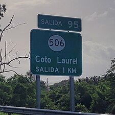 PR-52 south approaching exit 95 to PR-506 in Barrio Coto Laurel
 -
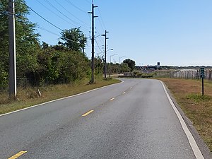
 Puerto Rico Highway 506 heading north from Autopista Luis A. Ferré (PR-52)


Major intersections
The entire route is located in Coto Laurel, Ponce.
| km[2] | mi | Destinations | Notes | ||
|---|---|---|---|---|---|
| 2.0 | 1.2 | Southern terminus of PR-506 at Urbanización Hacienda Juliana | |||
| 1.6– 1.5 | 0.99– 0.93 | PR-52 – Ponce, San Juan | Diamond interchange; PR-52 (unsigned PRI-1) exit 95 | ||
| 0.0 | 0.0 | PR-14 – Ponce, Juana Díaz | Northern terminus of PR-506; unsigned | ||
| 1.000 mi = 1.609 km; 1.000 km = 0.621 mi | |||||
Related route
Highway 5506 | |
|---|---|
| Location | Ponce |
| Length | 1.4 km[7] (0.87 mi) |

Puerto Rico Highway 5506 (PR-5506) is an important tributary of PR-506. This is a two-lane tertiary road which intersects with PR-1 and the southern terminus of PR-10, an important primary highway.[8] The entire route is located in Ponce.
-
 Counterclockwise terminus of PR-5506 in Barrio Sabanetas
 -
 PR-5506 in Barrio Sabanetas


| Location | km[7] | mi | Destinations | Notes | |
|---|---|---|---|---|---|
| Vayas–Sabanetas line | 0.0 | 0.0 |  PR-1 – Santa Isabel, Ponce PR-1 – Santa Isabel, Ponce | Clockwise terminus of PR-5506 | |
| 1.4 | 0.87 |   PR-10 north (Carretera Salvador "Chiry" Vasallo Ruiz) – San Juan, Adjuntas PR-10 north (Carretera Salvador "Chiry" Vasallo Ruiz) – San Juan, Adjuntas | Counterclockwise terminus of PR-5506 and southern terminus of PR-10; PR-52 access is via PR-10; PR-52 exit 98B | ||
| Aeropuerto Mercedita (Avenida Aeropuerto), Central Mercedita (Calle La Esperanza) | |||||
| 1.000 mi = 1.609 km; 1.000 km = 0.621 mi | |||||
See also
 Puerto Rico portal
 U.S. Roads portal

References
- ^ "Para designar el tramo de la Carretera PR-506 que conecta la PR-14 hasta las Empresas Vassallo en el Barrio Coto Laurel de Ponce, como Doctor Humberto Zayas Chardón". LexJuris (Leyes y Jurisprudencia) de Puerto Rico (in Spanish). 2012. Retrieved 1 June 2019.
- ^ a b Google (1 March 2020). "PR-506" (Map). Google Maps. Google. Retrieved 1 March 2020.
- ^ "Tránsito Promedio Diario (AADT)". Transit Data (Datos de Transito) (in Spanish). DTOP PR. p. 114. Archived from the original on 1 April 2019.
- ^ Industrias Vassallo: Finely Crafted. Industry Today. 2019. Accessed 7 December 2019.
- ^ Cristalia Premium Water. HEREwego.com Accessed 3 December 2019.
- ^ Cristalia Water. Verdict Media Limited. 2007. Accessed 3 December 2019.
- ^ a b Google (1 March 2020). "PR-5506" (Map). Google Maps. Google. Retrieved 1 March 2020.
- ^ "Guía de Carreteras Principales, Expresos y Autopistas (in Spanish)". DTOP GOV PR.
External links
 Media related to Puerto Rico Highway 506 and Puerto Rico Highway 5506 at Wikimedia Commons
- PR-506, Ponce, Puerto Rico


