Rocchetta Nervina
Comune in Liguria, Italy

Coat of arms
Location of Rocchetta Nervina

43°53′N 7°36′E / 43.883°N 7.600°E / 43.883; 7.600
(31 Dec. 2010)[2]
18030
Rocchetta Nervina (Ligurian: A Rochetta[3]) is a comune (municipality) in the province of Imperia in the Italian region of Liguria. It is located about 120 kilometres (75 mi) southwest of Genoa and about 35 kilometres (22 mi) west of Imperia, on the border with France.
Geography
As of 31 December 2010, Rocchetta Nervina had a population of 275 and an area of 15.1 square kilometres (5.8 sq mi).[4]
Rocchetta Nervina borders the following municipalities: Apricale, Breil-sur-Roya (France), Dolceacqua, Isolabona, Pigna and Saorge (France).
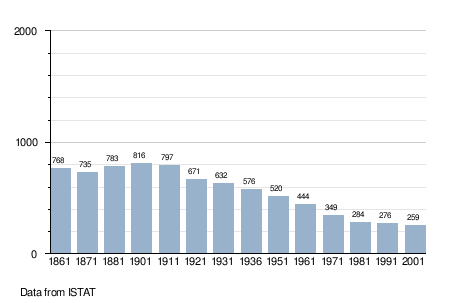
Demographic evolution
See also
References
- ^ "Superficie di Comuni Province e Regioni italiane al 9 ottobre 2011". Italian National Institute of Statistics. Retrieved 16 March 2019.
- ^ "Popolazione Residente al 1° Gennaio 2018". Italian National Institute of Statistics. Retrieved 16 March 2019.
- ^ Frisoni, Gaetano [in Italian] (1910). Dizionario Genovese-Italiano e Italiano-Genovese (in Italian). Genova: Nuova Editrice Genovese.
- ^ All demographics and other statistics: Italian statistical institute Istat.
External links
- Rocchetta Nervina official website
- v
- t
- e
- Airole
- Apricale
- Aquila d'Arroscia
- Armo
- Aurigo
- Badalucco
- Bajardo
- Bordighera
- Borghetto d'Arroscia
- Borgomaro
- Camporosso
- Caravonica
- Castellaro
- Castel Vittorio
- Ceriana
- Cervo
- Cesio
- Chiusanico
- Chiusavecchia
- Cipressa
- Civezza
- Costarainera
- Diano Arentino
- Diano Castello
- Diano Marina
- Diano San Pietro
- Dolceacqua
- Dolcedo
- Imperia
- Isolabona
- Lucinasco
- Mendatica
- Molini di Triora
- Montalto Carpasio
- Montegrosso Pian Latte
- Olivetta San Michele
- Ospedaletti
- Perinaldo
- Pietrabruna
- Pieve di Teco
- Pigna
- Pompeiana
- Pontedassio
- Pornassio
- Prelà
- Ranzo
- Rezzo
- Riva Ligure
- Rocchetta Nervina
- San Bartolomeo al Mare
- San Biagio della Cima
- San Lorenzo al Mare
- Sanremo
- Santo Stefano al Mare
- Seborga
- Soldano
- Cosio di Arroscia
- Taggia
- Terzorio
- Triora
- Vallebona
- Vallecrosia
- Vasia
- Ventimiglia
- Vessalico
- Villa Faraldi
 | This Liguria location article is a stub. You can help Wikipedia by expanding it. |
- v
- t
- e


