Saint-André-sur-Orne
You can help expand this article with text translated from the corresponding article in French. (May 2013) Click [show] for important translation instructions.
- View a machine-translated version of the French article.
- Machine translation, like DeepL or Google Translate, is a useful starting point for translations, but translators must revise errors as necessary and confirm that the translation is accurate, rather than simply copy-pasting machine-translated text into the English Wikipedia.
- Do not translate text that appears unreliable or low-quality. If possible, verify the text with references provided in the foreign-language article.
- You must provide copyright attribution in the edit summary accompanying your translation by providing an interlanguage link to the source of your translation. A model attribution edit summary is
Content in this edit is translated from the existing French Wikipedia article at [[:fr:Saint-André-sur-Orne]]; see its history for attribution. - You may also add the template
{{Translated|fr|Saint-André-sur-Orne}}to the talk page. - For more guidance, see Wikipedia:Translation.
Commune in Normandy, France
Saint-André-sur-Orne | ||
|---|---|---|
Commune | ||
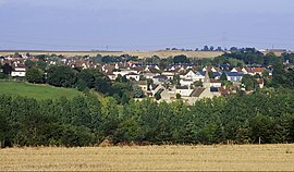 A general view of Saint-André-sur-Orne | ||
Location of Saint-André-sur-Orne  | ||
(2020–2026) Christian Delbruel[1] | | |
| Area 1 | 3.68 km2 (1.42 sq mi) | |
| Population (2021)[2] | 1,790 | |
| • Density | 490/km2 (1,300/sq mi) | |
| Time zone | UTC+01:00 (CET) | |
| • Summer (DST) | UTC+02:00 (CEST) | |
| INSEE/Postal code | 14556 /14320 | |
| Elevation | 3–53 m (9.8–173.9 ft) (avg. 30 m or 98 ft) | |
| 1 French Land Register data, which excludes lakes, ponds, glaciers > 1 km2 (0.386 sq mi or 247 acres) and river estuaries. | ||
Saint-André-sur-Orne (French pronunciation: [sɛ̃.t‿ɑ̃dʁe syʁ ɔʁn] ⓘ, literally Saint-André on Orne; named Saint-André-de-Fontenay until 1911) is a village in the Calvados department in the Normandy region in northwestern France.
Geography
Saint-André-sur-Orne is situated on the Orne River, 7 km south of Caen and 35 km south-east of Bayeux.
History
The village's history is closely linked to the Saint Stephen abbey "Abbaye Saint-Étienne-de-Fontenay" founded on his land of Fontenay by Raoul Tesson around 1047 under the patronage of Duke William of Normandy (before he became King of England following his victory in Hastings in 1066) and which survived until the French Revolution at the end of the 18th century. Most of the abbey was destroyed at the beginning of the 19th century, but there still remains a 13th-century building along the Orne river, and the abbot's more "modern" house (not visited) rebuilt at the beginning of the 18th century.
The village witnessed the expulsion of many schoolchildren from the "Maison du Clos" by the Nazi army during World War II, but the marching children were then rescued by Allied soldiers.[3] The village was finally liberated in July 1944 by Canadian soldiers, many of whom died in this fierce battle, hence the street names of "Royal Black Watch" (the Montreal-based regiment) and the village's main street "Rue des Canadiens". Their bodies are buried in the Bretteville-sur-Laize Canadian War Cemetery in the nearby village of Cintheaux.
Population
| Year | Pop. | ±% p.a. |
|---|---|---|
| 1968 | 1,044 | — |
| 1975 | 1,156 | +1.47% |
| 1982 | 1,242 | +1.03% |
| 1990 | 1,310 | +0.67% |
| 1999 | 1,606 | +2.29% |
| 2009 | 1,937 | +1.89% |
| 2014 | 1,793 | −1.53% |
| 2020 | 1,814 | +0.19% |
| Source: INSEE[4] | ||
See also
References
- ^ "Répertoire national des élus: les maires". data.gouv.fr, Plateforme ouverte des données publiques françaises (in French). 2 December 2020.
- ^ "Populations légales 2021". The National Institute of Statistics and Economic Studies. 28 December 2023.
- ^ Nancy Amis, The Orphans of Normandy, Anthenium Books, New York and London (2003)
- ^ Population en historique depuis 1968, INSEE
Wikimedia Commons has media related to Saint-André-sur-Orne.
- v
- t
- e
 Communes of the Calvados department
- Ablon
- Agy
- Amayé-sur-Orne
- Amayé-sur-Seulles
- Amfreville
- Angerville
- Anisy
- Annebault
- Arganchy
- Argences
- Arromanches-les-Bains
- Asnelles
- Asnières-en-Bessin
- Auberville
- Aubigny
- Audrieu
- Aure sur Mer
- Aurseulles
- Authie
- Les Authieux-sur-Calonne
- Auvillars
- Avenay
- Balleroy-sur-Drôme
- Banneville-la-Campagne
- Banville
- Barbery
- Barbeville
- Barneville-la-Bertran
- Baron-sur-Odon
- Barou-en-Auge
- Basly
- Basseneville
- Bavent
- Bayeuxsubpr
- Bazenville
- La Bazoque
- Beaufour-Druval
- Beaumais
- Beaumesnil
- Beaumont-en-Auge
- Bellengreville
- Belle Vie en Auge
- Benerville-sur-Mer
- Bénouville
- Bény-sur-Mer
- Bernesq
- Bernières-d'Ailly
- Bernières-sur-Mer
- Beuvillers
- Beuvron-en-Auge
- Biéville-Beuville
- Blainville-sur-Orne
- Blangy-le-Château
- Blay
- Blonville-sur-Mer
- Le Bô
- La Boissière
- Bonnebosq
- Bonnemaison
- Bonneville-la-Louvet
- Bonneville-sur-Touques
- Bonnœil
- Bons-Tassilly
- Bougy
- Boulon
- Bourgeauville
- Bourguébus
- Branville
- Brémoy
- Bretteville-le-Rabet
- Bretteville-sur-Laize
- Bretteville-sur-Odon
- Le Breuil-en-Auge
- Le Breuil-en-Bessin
- Le Brévedent
- Bréville-les-Monts
- Bricqueville
- Brucourt
- Bucéels
- Le Bû-sur-Rouvres
- Cabourg
- Caenpref
- Cagny
- Cahagnes
- Cahagnolles
- La Caine
- Cairon
- La Cambe
- Cambes-en-Plaine
- Cambremer
- Campagnolles
- Campigny
- Canapville
- Canchy
- Canteloup
- Carcagny
- Cardonville
- Carpiquet
- Cartigny-l'Épinay
- Le Castelet
- Castillon
- Castillon-en-Auge
- Castine-en-Plaine
- Caumont-sur-Aure
- Cauvicourt
- Cauville
- Cernay
- Cesny-aux-Vignes
- Cesny-les-Sources
- Chouain
- Cintheaux
- Clarbec
- Clécy
- Cléville
- Colleville-Montgomery
- Colleville-sur-Mer
- Colombelles
- Colombières
- Colombiers-sur-Seulles
- Colomby-Anguerny
- Combray
- Commes
- Condé-en-Normandie
- Condé-sur-Ifs
- Condé-sur-Seulles
- Coquainvilliers
- Cordebugle
- Cordey
- Cormelles-le-Royal
- Cormolain
- Cossesseville
- Cottun
- Courcy
- Courseulles-sur-Mer
- Courtonne-la-Meurdrac
- Courtonne-les-Deux-Églises
- Courvaudon
- Crépon
- Cresserons
- Cresseveuille
- Creully sur Seulles
- Cricquebœuf
- Cricqueville-en-Auge
- Cricqueville-en-Bessin
- Cristot
- Crocy
- Croisilles
- Crouay
- Culey-le-Patry
- Cussy
- Cuverville
- Damblainville
- Danestal
- Deauville
- Démouville
- Le Détroit
- Deux-Jumeaux
- Dialan sur Chaîne
- Dives-sur-Mer
- Donnay
- Douville-en-Auge
- Douvres-la-Délivrande
- Dozulé
- Drubec
- Ducy-Sainte-Marguerite
- Ellon
- Émiéville
- Englesqueville-en-Auge
- Englesqueville-la-Percée
- Épaney
- Épinay-sur-Odon
- Épron
- Équemauville
- Eraines
- Ernes
- Escoville
- Espins
- Esquay-Notre-Dame
- Esquay-sur-Seulles
- Esson
- Estrées-la-Campagne
- Éterville
- Étréham
- Évrecy
- Falaise
- Fauguernon
- Le Faulq
- Feuguerolles-Bully
- Fierville-les-Parcs
- Firfol
- Fleury-sur-Orne
- La Folie
- La Folletière-Abenon
- Fontaine-Étoupefour
- Fontaine-Henry
- Fontaine-le-Pin
- Fontenay-le-Marmion
- Fontenay-le-Pesnel
- Formentin
- Formigny La Bataille
- Foulognes
- Fourches
- Fourneaux-le-Val
- Le Fournet
- Fourneville
- Frénouville
- Le Fresne-Camilly
- Fresné-la-Mère
- Fresney-le-Puceux
- Fresney-le-Vieux
- Fumichon
- Gavrus
- Géfosse-Fontenay
- Genneville
- Gerrots
- Giberville
- Glanville
- Glos
- Gonneville-en-Auge
- Gonneville-sur-Honfleur
- Gonneville-sur-Mer
- Goustranville
- Gouvix
- Grainville-Langannerie
- Grainville-sur-Odon
- Grandcamp-Maisy
- Grangues
- Graye-sur-Mer
- Grentheville
- Grimbosq
- Guéron
- Hermanville-sur-Mer
- Hermival-les-Vaux
- Hérouville-Saint-Clair
- Hérouvillette
- Heuland
- La Hoguette
- Honfleur
- L'Hôtellerie
- Hotot-en-Auge
- Hottot-les-Bagues
- La Houblonnière
- Houlgate
- Ifs
- Isigny-sur-Mer
- Les Isles-Bardel
- Janville
- Jort
- Juaye-Mondaye
- Juvigny-sur-Seulles
- Laize-Clinchamps
- Landelles-et-Coupigny
- Landes-sur-Ajon
- Langrune-sur-Mer
- Léaupartie
- Leffard
- Lessard-et-le-Chêne
- Lingèvres
- Lion-sur-Mer
- Lisieuxsubpr
- Lison
- Lisores
- Litteau
- Livarot-Pays-d'Auge
- Les Loges
- Les Loges-Saulces
- Longues-sur-Mer
- Longueville
- Longvillers
- Loucelles
- Louvagny
- Louvigny
- Luc-sur-Mer
- Magny-en-Bessin
- Maisoncelles-Pelvey
- Maisoncelles-sur-Ajon
- Maisons
- Maizet
- Maizières
- Malherbe-sur-Ajon
- Maltot
- Mandeville-en-Bessin
- Manerbe
- Manneville-la-Pipard
- Le Manoir
- Manvieux
- Le Marais-la-Chapelle
- Marolles
- Martainville
- Martigny-sur-l'Ante
- Mathieu
- May-sur-Orne
- Merville-Franceville-Plage
- Méry-Bissières-en-Auge
- Meslay
- Le Mesnil-au-Grain
- Le Mesnil-Eudes
- Le Mesnil-Guillaume
- Le Mesnil-Robert
- Le Mesnil-Simon
- Le Mesnil-sur-Blangy
- Le Mesnil-Villement
- Meuvaines
- Mézidon Vallée d'Auge
- Le Molay-Littry
- Les Monceaux
- Monceaux-en-Bessin
- Mondeville
- Mondrainville
- Monfréville
- Montfiquet
- Montigny
- Montillières-sur-Orne
- Montreuil-en-Auge
- Monts-en-Bessin
- Les Monts d'Aunay
- Morteaux-Coulibœuf
- Mosles
- Mouen
- Moulines
- Moulins en Bessin
- Moult-Chicheboville
- Les Moutiers-en-Auge
- Les Moutiers-en-Cinglais
- Moyaux
- Mutrécy
- Nonant
- Norolles
- Noron-l'Abbaye
- Noron-la-Poterie
- Norrey-en-Auge
- Notre-Dame-de-Livaye
- Notre-Dame-d'Estrées-Corbon
- Noues de Sienne
- Olendon
- Orbec
- Osmanville
- Ouézy
- Ouffières
- Ouilly-du-Houley
- Ouilly-le-Tesson
- Ouilly-le-Vicomte
- Ouistreham
- Parfouru-sur-Odon
- Pennedepie
- Périers-en-Auge
- Périers-sur-le-Dan
- Périgny
- Perrières
- Pertheville-Ners
- Petiville
- Pierrefitte-en-Auge
- Pierrefitte-en-Cinglais
- Pierrepont
- Le Pin
- Planquery
- Plumetot
- La Pommeraye
- Pont-Bellanger
- Pont-d'Ouilly
- Pontécoulant
- Pont-Farcy
- Pont-l'Évêque
- Port-en-Bessin-Huppain
- Ponts sur Seulles
- Potigny
- Préaux-Bocage
- Le Pré-d'Auge
- Prêtreville
- Putot-en-Auge
- Quetteville
- Ranchy
- Ranville
- Rapilly
- Repentigny
- Reux
- Reviers
- La Rivière-Saint-Sauveur
- La Roque-Baignard
- Rocques
- Rosel
- Rots
- Rouvres
- Rubercy
- Rumesnil
- Ryes
- Saint-André-d'Hébertot
- Saint-André-sur-Orne
- Saint-Arnoult
- Saint-Aubin-d'Arquenay
- Saint-Aubin-des-Bois
- Saint-Aubin-sur-Mer
- Saint-Benoît-d'Hébertot
- Saint-Côme-de-Fresné
- Saint-Contest
- Saint-Denis-de-Mailloc
- Saint-Denis-de-Méré
- Saint-Désir
- Sainte-Croix-sur-Mer
- Sainte-Honorine-de-Ducy
- Sainte-Honorine-du-Fay
- Sainte-Marguerite-d'Elle
- Sainte-Marie-Outre-l'Eau
- Saint-Étienne-la-Thillaye
- Saint-Gatien-des-Bois
- Saint-Germain-de-Livet
- Saint-Germain-du-Pert
- Saint-Germain-la-Blanche-Herbe
- Saint-Germain-Langot
- Saint-Germain-le-Vasson
- Saint-Hymer
- Saint-Jean-de-Livet
- Saint-Jouin
- Saint-Julien-sur-Calonne
- Saint-Lambert
- Saint-Laurent-de-Condel
- Saint-Laurent-sur-Mer
- Saint-Léger-Dubosq
- Saint-Louet-sur-Seulles
- Saint-Loup-Hors
- Saint-Manvieu-Norrey
- Saint-Marcouf
- Saint-Martin-aux-Chartrains
- Saint-Martin-de-Bienfaite-la-Cressonnière
- Saint-Martin-de-Blagny
- Saint-Martin-de-Fontenay
- Saint-Martin-de-la-Lieue
- Saint-Martin-de-Mailloc
- Saint-Martin-de-Mieux
- Saint-Martin-des-Entrées
- Saint-Omer
- Saint-Ouen-du-Mesnil-Oger
- Saint-Ouen-le-Pin
- Saint-Pair
- Saint-Paul-du-Vernay
- Saint-Philbert-des-Champs
- Saint-Pierre-Azif
- Saint-Pierre-Canivet
- Saint-Pierre-des-Ifs
- Saint-Pierre-du-Bû
- Saint-Pierre-du-Fresne
- Saint-Pierre-du-Jonquet
- Saint-Pierre-du-Mont
- Saint-Pierre-en-Auge
- Saint-Rémy
- Saint-Samson
- Saint-Sylvain
- Saint-Vaast-en-Auge
- Saint-Vaast-sur-Seulles
- Saint-Vigor-le-Grand
- Sallen
- Sallenelles
- Sannerville
- Saon
- Saonnet
- Sassy
- Seulline
- Soignolles
- Soliers
- Sommervieu
- Soulangy
- Souleuvre en Bocage
- Soumont-Saint-Quentin
- Subles
- Sully
- Surrain
- Surville
- Terres de Druance
- Tessel
- Thaon
- Le Theil-en-Auge
- Thue et Mue
- Thury-Harcourt-le-Hom
- Tilly-sur-Seulles
- Le Torquesne
- Touffréville
- Touques
- Tour-en-Bessin
- Tourgéville
- Tournières
- Tourville-en-Auge
- Tourville-sur-Odon
- Tracy-Bocage
- Tracy-sur-Mer
- Tréprel
- Trévières
- Troarn
- Le Tronquay
- Trouville-sur-Mer
- Trungy
- Urville
- Ussy
- Vacognes-Neuilly
- Valambray
- Valdallière
- Val d'Arry
- Val de Drôme
- Val-de-Vie
- Valorbiquet
- Valsemé
- Varaville
- Vaucelles
- Vauville
- Vaux-sur-Aure
- Vaux-sur-Seulles
- Vendes
- Vendeuvre
- Versainville
- Verson
- Ver-sur-Mer
- La Vespière-Friardel
- Le Vey
- Vicques
- Victot-Pontfol
- Vienne-en-Bessin
- Vierville-sur-Mer
- Vieux
- Vieux-Bourg
- Vignats
- Villers-Bocage
- Villers-Canivet
- Villers-sur-Mer
- Villerville
- La Villette
- Villons-les-Buissons
- Villy-Bocage
- Villy-lez-Falaise
- Vimont
- Vire Normandiesubpr
- pref: prefecture
- subpr: subprefecture
Authority control databases | |
|---|---|
| International |
|
| National |
|
 | This Calvados geographical article is a stub. You can help Wikipedia by expanding it. |
- v
- t
- e


