Schaalsee
53°35′25″N 10°54′52″E / 53.59028°N 10.91444°E / 53.59028; 10.91444Primary outflows Schaalsee-Kanal, Schaale Catchment area 180 km2 (69 sq mi) Basin countries Germany Surface area 23.5 km2 (9.1 sq mi) Average depth 17 m (56 ft) Max. depth 71.5 m (235 ft) Residence time 5 to 10 years Surface elevation 35 m (115 ft) Islands (Kampenwerder, Stintenburginsel, Rethwiese) Settlements Zarrentin, Seedorf
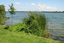
Schaalsee is a 24 km2 (9.3 sq mi) lake in Germany. It forms part of the border between Schleswig-Holstein (district Herzogtum Lauenburg) and Mecklenburg-Vorpommern (districts Ludwigslust-Parchim and Nordwestmecklenburg). The town of Zarrentin is located on its southern shores. Other municipalities on the lake are Seedorf, Sterley, Salem, Kittlitz and Kneese.
It was declared a biosphere reserve in 2000 (309 km2).
External links
- Schaalsee-Elbe Biosphere Reserve
- Nixdorf, B.; et al. (2004), "Schaalsee", Dokumentation von Zustand und Entwicklung der wichtigsten Seen Deutschlands (in German), Berlin: Umweltbundesamt, p. 71
- Agroforstprojekt am Schaalsee
- v
- t
- e
Biosphere reserves in Germany
- Berchtesgaden Alps
- Black Forest
- Bliesgau
- Middle Elbe
- Palatinate Forest
- Rhön Mountains
- Rügen
- Schaalsee
- Schorfheide-Chorin
- Spreewald
- Swabian Jura
- Thuringian Forest
- Upper Lusatia
- Vesser Valley Thuringian Forest
- Vilm
- Wadden Sea
This article related to a protected area in Europe is a stub. You can help Wikipedia by expanding it. |
- v
- t
- e