Timrå
Place in Medelpad, Sweden
62°29′13″N 17°19′33″E / 62.48694°N 17.32583°E / 62.48694; 17.32583 (31 December 2010)[1]
860 xx
Timrå (pronunciationⓘ) is a locality and the seat of Timrå Municipality in Västernorrland County, Sweden with 10,443 inhabitants in 2010.[1]
It is located about 13 km north of Sundsvall (a town with a metropolitan area of some 100,000 inhabitants), and could arguably be considered a satellite to that town.
The two closest cities (Sundsvall and Härnösand) share one airport, Midlanda, that is geographically located in Timrå.
Indalsälven, one of Sweden's largest rivers with a length of 430 km, meets the Gulf of Botnia in Timrå.
In Sweden, Timrå is mainly known for its ice hockey club Timrå IK, which, as of season 2023/24 plays in the Swedish top division SHL.
In 1995, Swedish artist Bengt Lindström constructed the Y, a 30 meter high sculpture located in Timrå.
Local legend says that Sörberge, on the north side of the town, is haunted by a tall man wearing a very large coat called 'Stor Bubbas'.
Climate
Timrå has historically had a subarctic climate, but it has in recent decades more resembled a cool-summer humid continental climate.
| Climate data for Sundsvall Airport (2002–2021); extremes since 1943; sunshine[2] 1961–1990 | |||||||||||||
|---|---|---|---|---|---|---|---|---|---|---|---|---|---|
| Month | Jan | Feb | Mar | Apr | May | Jun | Jul | Aug | Sep | Oct | Nov | Dec | Year |
| Record high °C (°F) | 11.0 (51.8) | 13.8 (56.8) | 15.2 (59.4) | 21.9 (71.4) | 27.4 (81.3) | 35.0 (95.0) | 33.0 (91.4) | 31.3 (88.3) | 27.2 (81.0) | 21.5 (70.7) | 14.0 (57.2) | 10.5 (50.9) | 35.0 (95.0) |
| Mean maximum °C (°F) | 5.3 (41.5) | 6.8 (44.2) | 11.5 (52.7) | 16.8 (62.2) | 22.2 (72.0) | 25.7 (78.3) | 27.8 (82.0) | 26.0 (78.8) | 21.1 (70.0) | 14.5 (58.1) | 8.8 (47.8) | 6.7 (44.1) | 28.8 (83.8) |
| Mean daily maximum °C (°F) | −2.5 (27.5) | −1.2 (29.8) | 3.3 (37.9) | 8.6 (47.5) | 14.0 (57.2) | 18.8 (65.8) | 21.7 (71.1) | 20.0 (68.0) | 15.3 (59.5) | 8.3 (46.9) | 2.6 (36.7) | −0.6 (30.9) | 9.0 (48.2) |
| Daily mean °C (°F) | −6.5 (20.3) | −5.6 (21.9) | −1.4 (29.5) | 3.5 (38.3) | 8.6 (47.5) | 13.5 (56.3) | 16.7 (62.1) | 15.6 (60.1) | 10.8 (51.4) | 4.6 (40.3) | −0.4 (31.3) | −4.1 (24.6) | 4.6 (40.3) |
| Mean daily minimum °C (°F) | −10.4 (13.3) | −10.0 (14.0) | −6.1 (21.0) | −1.7 (28.9) | 3.2 (37.8) | 8.2 (46.8) | 11.7 (53.1) | 10.6 (51.1) | 6.2 (43.2) | 0.8 (33.4) | −3.4 (25.9) | −7.6 (18.3) | 0.1 (32.2) |
| Mean minimum °C (°F) | −22.5 (−8.5) | −21.5 (−6.7) | −17.4 (0.7) | −7.4 (18.7) | −3.0 (26.6) | 2.3 (36.1) | 6.1 (43.0) | 4.5 (40.1) | −0.1 (31.8) | −6.4 (20.5) | −11.5 (11.3) | −16.8 (1.8) | −24.9 (−12.8) |
| Record low °C (°F) | −35.5 (−31.9) | −34.8 (−30.6) | −34.2 (−29.6) | −20.0 (−4.0) | −8.2 (17.2) | −2.0 (28.4) | 1.9 (35.4) | −0.6 (30.9) | −7.7 (18.1) | −15.2 (4.6) | −22.1 (−7.8) | −36.6 (−33.9) | −36.6 (−33.9) |
| Average precipitation mm (inches) | 56.1 (2.21) | 31.7 (1.25) | 30.5 (1.20) | 27.6 (1.09) | 43.3 (1.70) | 46.9 (1.85) | 58.8 (2.31) | 72.5 (2.85) | 59.6 (2.35) | 63.6 (2.50) | 51.0 (2.01) | 59.1 (2.33) | 600.7 (23.65) |
| Average extreme snow depth cm (inches) | 38 (15) | 45 (18) | 43 (17) | 23 (9.1) | 0 (0) | 0 (0) | 0 (0) | 0 (0) | 0 (0) | 0 (0) | 9 (3.5) | 22 (8.7) | 52 (20) |
| Mean monthly sunshine hours | 43 | 81 | 135 | 185 | 259 | 287 | 267 | 215 | 142 | 98 | 57 | 34 | 1,803 |
| Source 1: SMHI Open Data for Sundsvall-Timrå flygplats, temperature[3] | |||||||||||||
| Source 2: SMHI Open Data for Stordala-Midlanda D, precipitation[4] | |||||||||||||
Notable citizens
- Lennart "Lillstrimma" Svedberg (1944–1972), ice hockey player
- Magdalena Forsberg (1967), cross country skier, biathlon
- Henrik Flyman, guitarist, composer, producer
- Henrik Forsberg (1967), cross country skier
- Mats Näslund (1959), ice hockey player
- Anna Olsson (1964), canoeist
- Anton Lander (1991), ice hockey player
Gallery
-
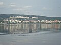 Timrå
Timrå -
 The municipal office
 -
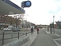 Town centre
 -
 Östrand pulp mill


References
Wikimedia Commons has media related to Timrå.
- ^ a b c "Tätorternas landareal, folkmängd och invånare per km2 2005 och 2010" (in Swedish). Statistics Sweden. 14 December 2011. Archived from the original on 27 January 2012. Retrieved 10 January 2012.
- ^ "NOAA WMO Normals 1691–1990". National Oceanic & Atmospheric Administration.
- ^ "SMHI Open Data for Sundsvall-Timrå flygplats, temperature" (in Swedish). Swedish Meteorological and Hydrological Institute. Retrieved 10 May 2022.
- ^ "SMHI Open Data for Stordala-Midlanda D, precipitation" (in Swedish). SMHI. Retrieved 10 May 2022.
External links
- TravelMath on Other cities, towns, and suburbs near Timra, Sweden
- v
- t
- e
- Bergeforsen
- Söråker
- Stavreviken
- Timrå (seat)
Municipalities and seats of Västernorrland County | ||
|---|---|---|
| Municipalities |  | |
| Municipal seats | ||
| Authority control databases |
|
|---|
 | This article about a location in Västernorrland County, Sweden is a stub. You can help Wikipedia by expanding it. |
- v
- t
- e


