Tomales Point
Headland in California, United States
38°14′27″N 122°59′43″W / 38.240854°N 122.995139°W / 38.240854; -122.995139
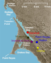
Tomales Point is the North-Western tip of Point Reyes Peninsula. Bodega Bay is to the North, Tomales Bay is to the East, and the Pacific Ocean is to the West. The point is accessible only via a 9.5 mile hike (out and back) along Tomales Point Trail. The region is home to a tule elk population.[1]
Gallery
-
 Tomales Point with Bodega Bay in the distance
 -
 Western edge of Point Reyes Peninsula on Tomales Point Trail
 -
 Entrance to Tomales Bay as viewed from Tomales Point
 -
 Tomales Bay
 -
 Herd of tule elk on Tomales Point Trail
 -
 A male tule elk


References
- ^ "Tomales Point Trailhead, Point Reyes National Seashore, National Park Service, Marin County". Bay Area Hiker. Retrieved 2023-06-17.
External links
Wikimedia Commons has media related to Tomales Point.
- v
- t
- e
West Marin
- Bolinas
- Dillon Beach
- Dogtown
- Inverness
- Inverness Park
- Lagunitas
- Marshall
- Muir Beach
- Nicasio
- Olema
- Point Reyes Station
- Stinson Beach
- Tomales
- Audubon Canyon Ranch
- Bolinas Lagoon
- Bolinas Ridge
- Bonita Channel
- Centissima Reef
- Copper Mine Gulch
- Drakes Bay
- Drakes Estero
- Golden Gate National Recreation Area
- Gull Rock
- Kent Island
- Nicasio Creek
- Nicasio Reservoir
- Olema Valley
- Pirates Cove
- Point Reyes
- Point Reyes National Seashore
- Rancho Punta de los Reyes Sobrante
- Rodeo Beach
- Rodeo Cove
- Rodeo Lagoon
- Sears Rock
- Tennessee Cove
- Tomales Bay
- Tomales Bay State Park
- Tomales Point
| Authority control databases |
|
|---|
 | This Marin County, California–related article is a stub. You can help Wikipedia by expanding it. |
- v
- t
- e


