Torres del Paine, Chile
Commune in Magallanes y Antártica Chilena, Chile
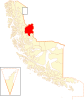
Location of the Torres del Paine commune in the Magallanes Region
51°15′33″S 72°20′42″W / 51.25917°S 72.34500°W / -51.25917; -72.34500Country  Chile
ChileRegion  Magallanes y Antártica Chilena
Province Última Esperanza Seat Cerro Castillo Government • Type Municipality • Alcalde Anahi Cardenas Rodríguez (Ind.) Area • Total 6,469.7 km2 (2,498.0 sq mi) Elevation 113 m (371 ft) Population • Total 180 • Density 0.028/km2 (0.072/sq mi) • Urban 0 • Rural 739 Sex • Men 543 • Women 196 Time zone UTC-4 (CLT[4]) • Summer (DST) UTC-3 (CLST[5]) Area code 56 + 61 Website Municipality of Torres del Paine 
 Chile
Chile Magallanes y Antártica Chilena
 (2012 Census)[3]
Torres del Paine is a Chilean commune located in the inland of Última Esperanza Province and Magallanes Region. The commune is administered by the municipality in Cerro Castillo, the major settlement in the commune. Torres del Paine National Park lies within the commune. Paine means "blue" in the native Tehuelche (Aonikenk) language and is pronounced PIE-nay.[6]
Demographics
According to the 2002 census of the National Statistics Institute, Torres del Paine spans an area of 6,469.7 km2 (2,498 sq mi) and has 739 inhabitants (543 men and 196 women), making the commune an entirely rural area. The population grew by 53.3% (257 persons) between the 1992 and 2002 censuses.[3]
Administration
As a commune, Torres del Paine is a third-level administrative division of Chile administered by a municipal council, headed by an alcalde who is directly elected every four years. The 2012-2016 alcalde is Anahi Cardenas Rodríguez (Ind.).[1][2]
Within the electoral divisions of Chile, Torres del Paine is represented in the Chamber of Deputies by Juan Morano (PDC) and Gabriel Boric (Ind.) as part of the 60th electoral district, which includes the entire Magallanes y la Antártica Chilena Region. The commune is represented in the Senate by Carlos Bianchi Chelech (Ind.) and Carolina Goic (PDC) as part of the 19th senatorial constituency (Magallanes y la Antártica Chilena Region).
Gallery
-
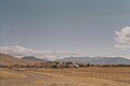 Field
Field -
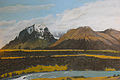
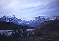 Torres del Paine
 -
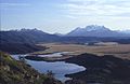
 Lake Grey
 -
 Lake Toro
 -


References
- ^ a b "Asociación Chilena de Municipalidades" (in Spanish). Retrieved 27 January 2011.
- ^ a b "Municipality of Torres del Paine" (in Spanish). Retrieved 27 January 2011.
- ^ a b c d "National Statistics Institute" (in Spanish). Retrieved 27 January 2010.
- ^ "Chile Time". WorldTimeZones.org. Archived from the original on 11 September 2007. Retrieved 26 September 2010.
- ^ "Chile Summer Time". WorldTimeZones.org. Archived from the original on 11 September 2007. Retrieved 26 September 2010.
- ^ Abraham, Rudolf (2011). Torres del Paine: Trekking in Chile's Premier National Park. Milnthorpe: Cicerone Press. p. 17. ISBN 978-1-84965-356-5. Retrieved 4 August 2015.
External links
- (in Spanish) Municipality of Torres del Paine
Wikimedia Commons has media related to Torres del Paine.
- v
- t
- e
Communes and municipalities in Magallanes y la Antártica Chilena Region
- Puerto Natales
- Torres del Paine

- Cabo de Hornos
- Antártica
ToC
Trending
Recent Change


