Vézère
You can help expand this article with text translated from the corresponding article in French. (April 2018) Click [show] for important translation instructions.
- View a machine-translated version of the French article.
- Machine translation, like DeepL or Google Translate, is a useful starting point for translations, but translators must revise errors as necessary and confirm that the translation is accurate, rather than simply copy-pasting machine-translated text into the English Wikipedia.
- Do not translate text that appears unreliable or low-quality. If possible, verify the text with references provided in the foreign-language article.
- You must provide copyright attribution in the edit summary accompanying your translation by providing an interlanguage link to the source of your translation. A model attribution edit summary is
Content in this edit is translated from the existing French Wikipedia article at [[:fr:Vézère]]; see its history for attribution. - You may also add the template
{{Translated|fr|Vézère}}to the talk page. - For more guidance, see Wikipedia:Translation.
River in France
| Vézère | |
|---|---|
 Le Saillant, bridge over the river Vézère | |
 | |
| Location | |
| Country | France |
| Physical characteristics | |
| Source | |
| • location | Plateau de Millevaches |
| • elevation | 970 m (3,180 ft) |
| Mouth | |
• location | Dordogne |
• coordinates | 44°52′53″N 0°53′26″E / 44.88139°N 0.89056°E / 44.88139; 0.89056 |
| Length | 211 km (131 mi) |
| Basin size | 3,708 km2 (1,432 sq mi) |
| Discharge | |
| • average | 50 m3/s (1,800 cu ft/s) |
| Basin features | |
| Progression | Dordogne→ Gironde estuary→ Atlantic Ocean |

UNESCO World Heritage Site
| UNESCO World Heritage Site | |
|---|---|
 Vézère at La Madeleine site | |
| Includes |
|
| Criteria | Cultural: (i)(iii) |
| Reference | 85 |
| Inscription | 1979 (3rd Session) |
The Vézère (French pronunciation: [vezɛʁ]; Occitan: Vesera) is a 211-km-long river in southwestern France. It is an important tributary to the Dordogne.[1] Its source is in the northwestern part of the elevated plateau known as the Massif Central. It flows into the Dordogne from the right near Le Bugue. The river Corrèze is a tributary of the Vézère.
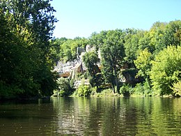
The Vézère Valley is famed for its prehistoric cave systems, containing numerous cave paintings and hominid remains. UNESCO collectively designated these a World Heritage Site in 1979. Among the sites with remarkable caves is Lascaux.
Geography
The Vézère takes its source in the bog of Longéroux, on the plateau of Millevaches, in the Massif Central in Corrèze, at 887 meters above sea level, in the commune of Meymac, west of the Puy Pendu (973 m) in the forest of Longéroux, at the place called sources de la Vézère. It flows into the Dordogne on the right bank at Limeuil, at an altitude of 50 metres. Its main tributary is the Corrèze; their confluence is located in the western suburbs of Brive-la-Gaillarde. Other tributaries are the Loyre, the Bradascou and the Brézou. The length of the Vézère is 211.2 km.[1]
Departments and main communes crossed
It flows southwest through the following departments and cities:
- In Corrèze: Pérols-sur-Vézère, Bugeat, Uzerche, Vigeois, Brive-la-Gaillarde
- In Dordogne: Montignac, Terrasson-Lavilledieu, Les Eyzies-de-Tayac-Sireuil, Le Bugue
Facilities
The Vézère to Uzerche. In its upstream part, the Vézère has three major dams: the dam of Monceaux la Virolle (or de Monceaux la Virole), the barrage at Treignac, located between 500 and 650 meters above sea level, and the dam at Saillant, a little lower.
Hydronymy
The river Visera is attested in Carolingian monastic medieval manuscripts in 889. It should not be confused in the Dordogne with the Upper Vézère, or Auvézère, a tributary of the L'Isle, 10 kilometers east of Périgueux.
The name Vézère comes, according to some scholars, from the ancient hydronym Vizara or Izara, formed by two contiguous Ligurian roots. The first, viz or iz, and the second ara. Viz or Iz means a "hollow Valley", and ara means a "watercourse", the word Vézère means "streams in the hollow valley".
It could also be a Celtic word Isara, meaning a "fast and impetuous flow (in case of flood)" to indicate to the travellers the dangers of a river during periods of intense rains or snow melt. The simple Latin variation is visara in the Gallo-Roman world which explains the logical phonetic evolution into Old French and Occitan.
Prehistoric sites and decorated caves in the Vézère valley
The Vézère valley was dubbed the "Valley of Mankind" from the end of the nineteenth century following the numerous discoveries of exceptional prehistoric sites, including the Abri de Crô-Magnon, a rock shelter, the cave of Font-de-Gaume, and the Combarelles caves in Les Eyzies. It also the location of the Lascaux cave in Montignac. The prehistoric and ornate caves of the Vézère Valley are classified as UNESCO World Heritage Sites.
References
- ^ a b Sandre. "Fiche cours d'eau - La Vézère (P---0100)".
External links
![]() Media related to Vézère at Wikimedia Commons
Media related to Vézère at Wikimedia Commons
- World Heritage profile
- v
- t
- e
- Palace and Park of Versailles
- Fontainebleau Palace and Park
- Paris: Banks of the Seine
- Provins

- Amiens Cathedral
- Belfries of Belgium and France1
- Bourges Cathedral
- Champagne hillsides, houses and cellars
- Chartres Cathedral
- Climats and terroirs of Burgundy
- Reims: Cathedral of Notre-Dame, Former Abbey of Saint-Rémi, Palace of Tau
- Abbey of Fontenay
- Le Havre
- Mont-Saint-Michel and its Bay
- Vézelay Church and hill
- Great Saltworks of Salins-les-Bains and Royal Saltworks of Arc-et-Senans
- Nancy: Place Stanislas, Place de la Carrière and Place d'Alliance
- Strasbourg: Grande Île, Neustadt
- Prehistoric pile dwellings around the Alps3
- The Architectural Work of Le Corbusier
- Canal du Midi
- Fortifications of Vauban
- Funerary and memory sites of the First World War (Western Front)4
- Loire Valley between Sully-sur-Loire and Chalonnes-sur-Loire
- Routes of Santiago de Compostela in France
- Ancient and Primeval Beech Forests of the Carpathians and Other Regions of Europe5
and territories
- 1Shared locally with other region/s and with Belgium
- 2Shared with Spain
- 3Shared with Austria, Germany, Italy, Slovenia and Switzerland
- 4Shared with Belgium
- 5Shared with Albania, Austria, Belgium, Bosnia and Herzegovina, Bulgaria, Croatia, Czech Republic, Germany, Italy, North Macedonia, Poland, Romania, Slovakia, Slovenia, Spain, Switzerland and Ukraine
Authority control databases | |
|---|---|
| International |
|
| National |
|
| Other |
|


