Walls of Thessaloniki
UNESCO World Heritage Site in Thessaloniki, Greece


Location of Walls of Thessaloniki in Greece
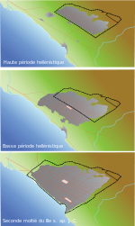

Growth of Thessaloniki and its walls in Antiquity (left) and in the late Roman and early Byzantine periods (right).
The Walls of Thessaloniki (Greek: Τείχη της Θεσσαλονίκης, Teíchi tis Thessaloníkis) are the 4 kilometer-long city walls surrounding the city of Thessaloniki during the Middle Ages and until the late 19th century, when large parts of the walls, including the entire seaward section, were demolished as part of the Ottoman authorities' restructuring of Thessaloniki's urban fabric. The city was fortified from its establishment in the late 4th century BC, but the present walls date from the early Byzantine period, ca. 390, and incorporate parts of an earlier, late 3rd-century wall. The walls consist of the typical late Roman mixed construction of ashlar masonry alternating with bands of brick. The northern part of the walls adjoins the acropolis of the city, which formed a separate fortified enceinte, and within it lies another citadel, the Heptapyrgion (Seven Towers), popularly known by the Ottoman translation of the name, Yedi Kule.
In 1988, as part of the Paleochristian and Byzantine monuments of Thessaloniki, the walls were added to the UNESCO World Heritage List because of their outstanding Byzantine architecture.[1]
History
The first fortification of the newly built city of Cassander, which played an important role, dates back to the 3rd century BC. The Roman conquest (167 BC), which brought Roman peace, made the walls weak, so around the middle of the 1st century they were already in ruins.[2]
In the 3rd century, fortifications were built to protect the city from the Goths with materials from previous buildings. With these fortifications, two Gothic attacks were repelled, in 254 and 268. The Roman wall was 1.65 m wide, with square towers.[2] The main street of the city (Leoforos or Mesi) extended from the Golden Gate in the west (Vardario Square) to the Cassandreot Gate in the east. The southern wall extended somewhat further south of today's Tsimiski avenue.
At the beginning of the 4th century, Galerius and Constantine the Great passed through Thessaloniki and strengthened the walls. At the end of the 4th century, a second wall was built outside the previous one with triangular projections. The wall visible today was built from the end of the 4th to the middle of the 5th century,[3] while a subsequent improvement program was implemented in the 7th century on Heraklion in order to support the defense of the city against the Avars and the Slavs. In 904 the city was captured by the Saracens by an attack from the sea side, which led to the sea walls being strengthened after the departure of the Saracens.
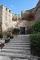
Gallery
-
 The walls c.1919
 -
 Part of the walls with one of the surviving gates on the background
 -
 Part of the walls
 -
 Gate of Anna Palaiologina
 -
 Part of the walls beside the street
 -
 Walls in Ano Poli
 -
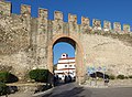 "Portara" Gate
 -
 Trigonio tower (“Triangle Tower”)
 -
 View from the Triangle tower
 -
 Another view


References
- ^ "Paleochristian and Byzantine monuments of Thessaloniki". UNESCO World Heritage Convention. United Nations Educational, Scientific, and Cultural Organization. Archived from the original on 5 January 2021. Retrieved 5 November 2022.
- ^ a b Apotypōmata : hē vyzantinē Thessalonikē se photographies kai schedia tēs Vretanikēs Scholēs Athēnōn (1888-1910) = Impressions : Byzantine Thessalonike through the photographs and drawings of the British School at Athens (1888-1910). Anastasia P. Pliōta. Thessalonikē. 2012. ISBN 978-960-9694-14-8. OCLC 863622662.
{{cite book}}: CS1 maint: location missing publisher (link) CS1 maint: others (link) - ^ Grissom, F. E.; Kahn, J. S. (December 1975). "Glyceraldehyde-3-phosphate dehydrogenases from Euglena gracilis. Purification and physical and chemical characterization". Archives of Biochemistry and Biophysics. 171 (2): 444–458. doi:10.1016/0003-9861(75)90053-3. ISSN 0003-9861. PMID 960.
Sources
- Kourkoutidou-Nikolaidou, E.; Tourta, A. (1997), Wandering in Byzantine Thessaloniki, Kapon Editions, pp. 15–26, ISBN 960-7254-47-3
External links
 Media related to Walls of Thessaloniki at Wikimedia Commons
- v
- t
- e
Landmarks of Thessaloniki
- Agios Athanasios tombs

- Arch of Galerius and Rotunda
- Las Incantadas
- Navarinou Square
- Roman Forum
- Palace of Galerius
- Catacombs of Thessaloniki
| UNESCO |
|
|---|
- Alaca Imaret Mosque
- Bey Hamam
- Church of Saint Gregory Palamas
- Immaculate Conception Cathedral
- Government House
- Lazarist Monastery
- White Tower of Thessaloniki
- Yahudi Hamam
- Yeni Mosque
- Egnatia Street
- Nikis Avenue
- Tsimiski Street
- Vasilissis Olgas Avenue
- Villa Allatini
- Villa Bianca
- Villa Mehmet Kapanci
- Villa A. Kapanci
- Villa Modiano
- Villa Mordoch
- Villa Petridi
- Gategno-Florentin Mansion
- Longos Mansion
- Moskof Mansion
- Stein Mansion
- Palataki
- State Conservatory of Thessaloniki
- Centre for Byzantine Research
- Seih Sou
- Nea Paralia
- Pedion tou Areos
- Pasha's Gardens [el]
- Marina Aretsou
- Labbatoir
- Ano Poli
- Stoa Malakopi
- Mikra British Cemetery
- Church of Taxiarches
- Archaeological Museum of Thessaloniki
- Atatürk Museum
- Museum of Byzantine Culture
- Cinema Museum
- French Museum of Zeitenlik
- Museum for the Macedonian Struggle
- NOESIS
- Macedonian Museum of Modern Art
- Museum of Photography
- State Museum of Modern Art
- Teloglion Foundation of Art
- War Museum
Byzantine monuments of Thessaloniki | ||
|---|---|---|
| UNESCO |
|  |
| Other |
| |
| Museums | ||
| ||
|---|---|---|
| North |
|     |
| Central |
| |
| Attica | ||
| South | ||
| Aegean Islands | ||


