Plaine de Kewu

Cette section ou cet article est une traduction incomplète ().
Vous pouvez modifier la page pour effectuer la traduction.

La plaine de Kewu, également appelée plaine de Prambanan d'après le plus connu des temples qui s'y trouve, est une plaine volcanique fertile qui s'étend entre le volcan Merapi au nord, le fleuve Bengawan Solo à l'est, la plaine de Bantul et la formation karsttique des Gunung Sewu au sud, le fleuve Progo à l'ouest, et la plaine de Kedu au nord-ouest. Elle est située à cheval sur le territoire spécial de Yogyakarta[1] et les kabupaten (départements) de Sleman et de Klaten et la ville de Surakarta dans la province de Java central).

Texte anglais à traduire :
It has been an important location in Central Javanese history and culture for over a millennium, since it contains many ancient archaeological remnants of historic significance. If each temples structure was counted separately, the 9th century Central Java period could be said to have produced thousands of temples, scattered from Shiva (Dieng) Plateau, Kedu Plain to Kewu Plain[2].
Apart from the Prambanan Lara Jonggrang complex, Kewu Plain, valley and hills around it is the location of some of the earliest Hindu-Buddhist temples in Indonesia. Adjacent to the complex to the north are Bubrah temple, Lumbung temple, and Sewu temple; to the east are found Plaosan temple. Kalasan temple and Sari temple are to the west, and further is the Sambisari temple. The Ratu Boko compounds are on higher ground just to the south. The discoveries of archaeological sites scattered only a few miles away suggested that this area was once an important religious, political, and urban center of central Java. Despite the smaller scale of its temples, the diversity and sophistication of the archaeological sites in this plain are comparable to Angkor archaeological site in Cambodia.
Traduire ce texte • Outils • (+)
Agriculture
Texte anglais à traduire :
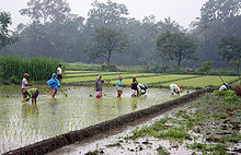
For centuries Prambanan Plain, overshadowed by Merapi volcano, was known for its rich and fertile volcanic soil perfect for intensive rice cultivation. The economy of Java relied heavily on rice agriculture, and the ancient polity of Central Java, with their complex political, economy and social systems, flourished on this plain.
The images of rice agriculture scenes and activities can be found in bas-reliefs in Borobudur and Prambanan. The early Mataram Kingdom was dependent on rice yields and tax collected from their subjects. Java was famous for rice surpluses and rice export, and rice agriculture contributed to the population growth of the island. Many of the rice paddies in the landscape remains unchanged from the earlier eras.
Traduire ce texte • Outils • (+)
Sites archéologiques

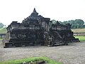
- Temple de Kalasan. D'après l'inscription du même nom, c'est le plus ancien temple construit dans la plaine.
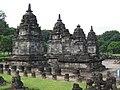
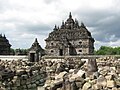
Les temples de la plaine de Kewu
-

-
 Lumbung
 -
 Bubrah
 -
 Sewu
Sewu -
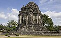 Kalasan
 -
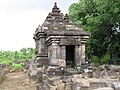
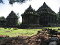
 Sari
Sari -
 Plaosan Lor
 -
 Plaosan Kidul
 -
 Gebang
 -
 Sambisari
 -
 Kedulan
 -
 Kimpulan (Pustakasala)
 -
 Sojiwan
 -
 Ratuboko
 -
 Banyunibo
 -
 Barong
 -
 Ijo
Ijo -
 Sari. Avril 2014.


Voir aussi
Sur les autres projets Wikimedia :
- Plaine de Kewu, sur Wikimedia Commons
Bibliographie
- Groneman, I. (Isaac), (1901). The Hindu ruins in the plain of Parambanan Soerabaia, G. C. T. Van Dorp & Co
- Maria Elizabeth Lulius van Goor (1922). A short guide to the ruined temples in the Prambanan Plain, the Dieng Plateau, and Gedong Sanga. Weltevreden [Indonesia] Landsdrukkerij
Notes
- ↑ Indonesia Handbook, 4e édition, 1988, p. 309 - 17 km north east of Yogyakrta et Indonesia de Lonely Planet, 8e édition, 2007, pp. 190-191
- ↑ Prambanan and Sewu Exhibition: Safeguarding a Common Heritage of Humanity, 15-24 janvier 2010, Bentara Budaya Jakarta 2010
 Portail de l’Indonésie
  Portail de l’archéologie


