Perbatasan Israel
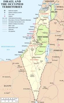
Perbatasan Negara Israel saat ini adalah hasil dari perang dan persetujuan diplomatik Israel, negara-negara tetanggannya, dan kekuatan-kekuatan kolonial. Uniknya, hanya ada dua dari lima perbatasan potensial Israel yang diakui mancanegara sementara tiga perbatasan lainnya dipersengketakan.[1] Perbatasan Israel dengan Mesir dan Yordania sekarang telah resmi diakui dan dikonfirmasi sebagai bagian dari perjanjian damai dengan negara-negara tersebut. Perbatasan dengan Suriah (Dataran Tinggi Golan), Lebanon (perkebunan Shebaa) dan teritorial Palestina (dideklarasikan sebagai Negara Palestina) masih dipersengketakan.[2]
Referensi
- ^ Newman, David (28 March 2012). "Borders and Conflict Resolution". Dalam Thomas M. Wilson and Hastings Donnan. A Companion to Border Studies. John Wiley & Sons. hlm. 252–. ISBN 978-1-118-25525-4.
Unique to states in the contemporary world, only two of Israel's five potential land borders have the status of internationally recognized boundaries.
- ^ Sela, Avraham. "Israel." The Continuum Political Encyclopedia of the Middle East. Ed. Sela. New York: Continuum, 2002. pp. 444-474
Daftar pustaka
- Alsberg, Paul Avraham (1973). "קביעת הגבול המזרחי של ארץ ישראל (Determining the Eastern Boundary of the Land of Israel)". Dalam Daniel Carpi. הציונות: מאסף לתולדות התנועה הציונית והישוב היהודי בארץ־ישראל. וניברסיטת תל-אביב, הוצאת הכבוץ המיוחד.
available in pdf here
- Alsberg, Avraham P. (1980). "Delimitation of the eastern border of Palestine". Zionism. 2. Institute for Zionist Research Founded in Memory of Chaim Weizmann. hlm. 87–98. doi:10.1080/13531048108575800.
- Agreement between His Majesty's Government and the French Government respecting the Boundary Line between Syria and Palestine from the Mediterranean to El Hámmé, Treaty Series No. 13 (1923), Cmd. 1910.
- Biger, Gideon (1989), Geographical and other arguments in delimitation in the boundaries of British Palestine, in "International Boundaries and Boundary Conflict Resolution", IBRU Conference, ISBN 1-85560-000-5, pp. 41–61.
- Biger, Gideon (1995), The encyclopedia of international boundaries, New York: Facts on File.
- Biger, Gideon (2005), The Boundaries of Modern Palestine, 1840-1947. London: Routledge. ISBN 0-7146-5654-2.
- Franco-British Convention on Certain Points Connected with the Mandates for Syria and the Lebanon, Palestine and Mesopotamia, signed Dec. 23, 1920. Text available in American Journal of International Law, Vol. 16, No. 3, 1922, 122–126.
- Gardus, Yehuda; Shmueli, Avshalom, ed. (1978–79). The Land of the Negev (English title) (dalam bahasa Ibrani). Ministry of Defense Publishing.
- Gil-Har, Yitzhak (1993), British commitments to the Arabs and their application to the Palestine-Trans-Jordan boundary: The issue of the Semakh triangle, Middle Eastern Studies, Vol.29, No.4, pp. 690–701.
- Klieman, Aaron S. (1970). Foundations of British policy in the Arab world: the Cairo Conference of 1921. Johns Hopkins Press.
- McTague, John (1982), Anglo-French Negotiations over the Boundaries of Palestine, 1919–1920, Journal of Palestine Studies, Vol. 11, No. 2, pp. 101–112.
- Muhsin, Yusuf (1991), The Zionists and the process of defining the borders of Palestine, 1915–1923, Journal of South Asian and Middle Eastern Studies, Vol. 15, No. 1, pp. 18–39.
- US Department of State, International Boundary Study series: Iraq-Jordan Diarsipkan 2008-04-07 di Wayback Machine., Iraq-Syria Diarsipkan 2008-04-07 di Wayback Machine., Jordan-Syria, Israel-Lebanon.


