Stroud (district)
Niet-metropolitaans district in Engeland  | |||
|---|---|---|---|
  | |||
| Situering | |||
| Land | Engeland | ||
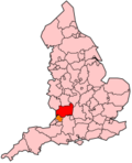
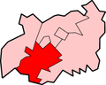
| County | Gloucestershire | ||
| Regio | South West England | ||
| Coördinaten | 51°44'53"NB, 2°12'58"WL | ||
| Algemeen | |||
| Oppervlakte | 460,65[1] km² | ||
| Inwoners (2018[2]) | 119.019 (258 inw./km²) | ||
| ONS-code | E07000082 | ||
| Detailkaart | |||
 | |||
| |||

Stroud is een Engels district in het shire-graafschap (non-metropolitan county OF county) Gloucestershire en telt 119.000 inwoners. De oppervlakte bedraagt 461 km². Hoofdplaats is Stroud.
Van de bevolking is 17,6% ouder dan 65 jaar. De werkloosheid bedraagt 2,4% van de beroepsbevolking (cijfers volkstelling 2001).
Plaatsen in district Stroud
- Slad
Civil parishes in district Stroud
Alderley, Alkington, Arlingham, Berkeley, Bisley-with-Lypiatt, Brimscombe and Thrupp, Brookthorpe-with-Whaddon, Cainscross, Cam, Chalford, Coaley, Cranham, Dursley, Eastington, Elmore, Frampton on Severn, Fretherne with Saul, Frocester, Ham and Stone, Hamfallow, Hardwicke, Harescombe, Haresfield, Hillesley and Tresham, Hinton, Horsley, King's Stanley, Kingswood, Leonard Stanley, Longney and Epney, Minchinhampton, Miserden, Moreton Valence, Nailsworth, North Nibley, Nympsfield, Owlpen, Painswick, Pitchcombe, Randwick, Rodborough, Slimbridge, Standish, Stinchcombe, Stonehouse, Stroud, Uley, Upton St. Leonards, Whiteshill and Ruscombe, Whitminster, Woodchester, Wotton-under-Edge.
Bronnen, noten en/of referenties
- Volkstelling 2001, Office for National Statistics


