San Rafael (Bulacan)
| San Rafael (Bulacan) | |||
|---|---|---|---|
 | |||
| Land |  Filippinene Filippinene | ||
| Status | kommune | ||
| Grunnlagt | 1758 | ||
| Postnummer | 3008 | ||
| Retningsnummer | 44 | ||
| Areal | 152,43 km²[1] | ||
| Befolkning | 103 097[2] (2020) | ||
| Bef.tetthet | 676,36 innb./km² | ||
| Antall husholdninger | 25 220 | ||
| Språk | Tagalog | ||
| Høyde o.h. | 23 meter | ||
| Nettside | www | ||
 San Rafael (Bulacan) 14°57′00″N 120°58′00″Ø | |||
San Rafael på Commons | |||
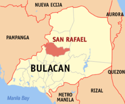
San Rafael (Bayan ng San Rafael) er en kommune på Filippinene. Kommunen ligger på øya Luzon, og tilhører provinsen Bulacan. Folkemengden var på 94 655 innbyggere i 2015.[3]
Barangayer
San Rafael er inndelt i 34 barangayer.[3]
|
|
|
Bildegalleri


Referanser
- ^ http://nap.psa.gov.ph/activestats/psgc/province.asp?provCode=031400000.
- ^ «2020 Census of Population and Housing (2020 CPH) Population Counts Declared Official by the President». folketellingen 2020. Filippinenes statistikkbyrå. 7. juli 2021.
- ^ a b Barangays in San Rafael (Bulacan) 2018 Philippine Standard Geographic Code (PSGC)
Kilder
- 2015 Census of Population and Housing Report Philippine Statistics Authority


