Prittlewell

Prittlewell
Ilustracja
Państwo

 Wielka Brytania

Kraj

 Anglia

Region

East of England

Hrabstwo ceremonialne

Essex

Unitary authority

Southend-on-Sea

Populacja (2011)
• liczba ludności


9 971

Nr kierunkowy

01702

Kod pocztowy

SS2

Położenie na mapie hrabstwa Essex
Mapa konturowa hrabstwa Essex, na dole znajduje się punkt z opisem „Prittlewell”
Położenie na mapie Wielkiej Brytanii
Mapa konturowa Wielkiej Brytanii, na dole po prawej znajduje się punkt z opisem „Prittlewell”
Położenie na mapie Anglii
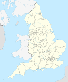
Mapa konturowa Anglii, na dole po prawej znajduje się punkt z opisem „Prittlewell”
51°32′53″N 0°42′18″E/51,548000 0,705000
Multimedia w Wikimedia Commons

Prittlewell – dzielnica miasta Southend-on-Sea, w Anglii, w Esseksie, w dystrykcie (unitary authority) Southend-on-Sea[1]. W 2011 osada liczyła 9 971 mieszkańców[2]. Prittlewell jest wspomniana w Domesday Book (1086) jako Pritteuuella[3].

Przypisy

  1. Ordnance Survey linked data
  2. Neighbourhood Statistics. [dostęp 2015-10-26]. [zarchiwizowane z tego adresu (2015-12-23)].
  3. The Domesday Book online
  • p
  • d
  • e
Miejscowości dystryktu Southend-on-Sea
  • Belfairs
  • Blenheim Park
  • Bournes Green
  • Chalkwell
  • Eastwood
  • Eastwoodbury
  • Eastwood Park
  • Kursaal
  • Leigh
  • Leigh-on-Sea
  • Milton
  • North Shoebury
  • Prittlewell
  • Shoeburyness
  • Southchurch
  • Southend-on-Sea
  • South Shoebury
  • St. Laurence
  • St. Luke's
  • Thorpe
  • Thorpe Bay
  • Victoria
  • Westborough
  • Westcliff-on-Sea
  • West Leigh
  • West Shoebury