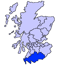
Dumfries e Galloway
| Dumfries e Galloway | |
|---|---|
 | |
| Geografia | |
| Área Total | 6.426 km² (3ª posição) |
| Categoria | Council Area |
| Sede Administrativa | Dumfries |
| Demografia | |
| População Total (2007) | 309.500 habitantes (5ª posição) |
| Densidade | 175 hab./km² |
| Política | |
| Nome do Conselho | Dumfries and Galloway Council |
| Site | http://www.dumgal.gov.uk/ |
A Área de Conselho (ou Council Area) de Dumfries e Galloway (em gaélico escocês, Dùn Phris agus an Gall-Ghaidhealaibh), é uma das 32 novas subdivisões administrativas da Escócia, criada em 1996. Faz fronteira com South Ayrshire e East Ayrshire a noroeste, South Lanarkshire e Scottish Borders a norte e com o Condado de Cumbria ao sul, na Inglaterra. É, também, banhado ao norte pelo Solway Firth e ao leste pela Mar da Irlanda.
Em 1975, com a abolição dos antigos condados, foi criado a região de Dumfries and Galloway mediante a fusão dos condados de Wigtownshire, Kirkcudbrightshire e Dumfriesshire. A reião foi, por sua vez, subdividida nos distritos de Wigtownshire, Stewartry, Nithsdale and Annandale e Eskdale. Em 1996, as regiões foram abolidas e esta região tornou-se uma unidade autoritária com a mesma área da antiga região de mesmo nome.
Geografia
A região de Dumfries e Galloway region é composta por desenas de sub-áreas e registration counties. Do leste para o oeste:
- Wigtownshire
- Rhins of Galloway • Machars
- Kirkcudbrightshire
- Stewartry
- Dumfriesshire
- Nithsdale • Annandale • Eskdale
Cidades e vilarejos
As cidades mais importantes estão em negrito.
- Ae, Airieland, Airds of Kells, Annan, Anwoth, Ardwell
- Beattock, Beeswing, Borgue, Brydekirk
- Caerlaverock, Cairngaan, Cairnryan, Cargenbridge, Carsphairn, Castle Douglas, Castle Kennedy, Clarencefield, Corsock, Creetown
- Dalbeattie, Dalton, Dornock, Drumlanrig, Drummore, Dumfries, Dundrennan, Dunscore
- Eastriggs, Ecclefechan, Eskdalemuir
- Garlieston, Gatehouse of Fleet, Glenluce, Gretna Green, Gretna
- Haugh of Urr, Hoddom
- Johnstonebridge
- Keir, Kippford, Kirkcolm, Kirkcudbright, Kirkpatrick Durham
- Langholm, Lochmaben, Lockerbie
- Middlebie, Millhousebridge, Moffat, Moniaive, Mull of Galloway
- New Abbey, New Galloway, New Luce, Newton Stewart, Newton Wamphray
- Parton, Penpont, Portpatrick
- Robgill Tower, Ringford
- Rigg, Ruthwell
- Sandhead, Sanquhar, St. John's Town of Dalry, Stranraer
- Terregles, Thornhill, Twynholm,Templand
- Unthank
- Wanlockhead, Whithorn, Wigtown
Escolas secundárias
- Annan Academy
- Castle Douglas High School
- Dalbeattie High School
- Douglas Ewart High School, Newton Stewart
- Dalry Secondary School
- Dumfries Academy
- Dumfries High School
- Kirkcudbright Academy
- Langholm Academy
- Lockerbie Academy
- Maxwelltown High School, Dumfries
- Moffat Academy
- Sanquhar Academy
- St Joseph's College
- Stranraer Academy
- Wallace Hall Academy, Thornhill
Lugares de interesse
- Castelo de Caerlaverock
- Castelo de Cardoness
- Castelo de Drumlanrig
- Lago Ken
- Castelo de MacLellan
- Castelo de Threave
Imagens de Dumfries e Galloway
-
 Dalveen Pass.
 -
 Sweetheart Abbey.
 -
 Torre Orchardton.
 -
 Reserva Nacional de Caerlaverock.
 -
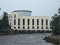 Tongland estação de energia.
 -
 Mull of Galloway.
 -
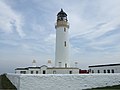 Farol do Mull of Galloway.
 -
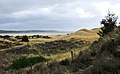 The Machars.
 -
 Devil's Beef Tub.
 -
 O porto de Port William.
 -
 Moffat.
 -
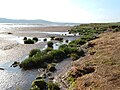
 Rio Nith Estuary.


| |
|---|---|
Aberdeen · Aberdeenshire · Angus · Argyll and Bute · Clackmannanshire · Dumfries and Galloway · Dundee · East Ayrshire · East Dunbartonshire · East Lothian East Renfrewshire · Edimburgo · Falkirk · Fife · Glasgow · Hébridas Exteriores · Highland · Inverclyde · Midlothian · Moray · North Ayrshire · North Lanarkshire · Órcades · Perth and Kinross · Renfrewshire · Scottish Borders · Shetland · South Ayrshire · South Lanarkshire · Stirling · West Dunbartonshire · West Lothian |

 | Este artigo sobre Geografia da Escócia é um esboço. Você pode ajudar a Wikipédia expandindo-o. |


