Robert Louis Stevenson State Park
State park in California, United States
38°39′12″N 122°36′12″W / 38.653416°N 122.603406°W / 38.653416; -122.603406
California Historical Landmark
Robert Louis Stevenson State Park is a California state park, located in Sonoma, Lake and Napa counties. The park offers a 5-mile (8 km) hike to the summit of Mount Saint Helena from which much of the Bay Area can be seen. On clear days it is possible to see the peak of Mount Shasta, 192 miles (310 km) distant.
Overview
The park is named after Robert Louis Stevenson, the Scottish author of Treasure Island and Kidnapped. In 1880, Stevenson and his new wife Fanny Vandegrift Osbourne spent their honeymoon living in a cabin at a played-out mine on the mountain along with Fanny's son Lloyd Osbourne. Although nothing remains of the cabin, the site is identified on the trail to the summit. Stevenson's book Silverado Squatters contains stories he wrote about his experiences during his visit to the area.
The area has rough terrain, with evergreen forests in the canyons on north-facing slopes and chaparral on the south-facing slopes.
Robert Louis Stevenson State Park is located off State Route 29 between Calistoga and Middletown. The park is registered as California Historical Landmark #710.[1]
2017 fire and temporary closure
As a result of a fire starting on Tubbs Lane in Calistoga, the park was temporarily closed on October 10, 2017.[2]
Gallery
-
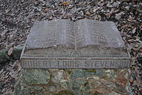 Robert Louis Stevenson monument in the park
 -
 The lower reaches of the park
 -
 Trail in the park towards the summit of Mount Saint Helena
 -
 Farther up on the trail
 -
 Rock formation in the park
 -
 Farther up on the trail
 -
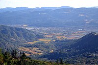 Northern Napa Valley viewed from Mount Saint Helena


References
- ^ a b "Robert Louis Stevenson State Park". Office of Historic Preservation, California State Parks. Retrieved October 10, 2012.
- ^ "Robert Louis Stevenson State Park". State of California. Archived from the original on October 15, 2017. Retrieved October 15, 2017.
{{cite web}}: CS1 maint: bot: original URL status unknown (link)
External links
Wikimedia Commons has media related to Robert Louis Stevenson State Park.
- Robert Louis Stevenson State Park website
- v
- t
- e
| |||||||||||||||||
National Forests and Grasslands | |||||||
|---|---|---|---|---|---|---|---|
| |||||||
|
| |||||||
| |||||||
|
|
- Heritage registers
- National Natural Landmarks
| |
|---|---|
| Books |
|
| Novels |
|
| Short story collections |
|
| Short stories |
|
| Poetry |
|
| Related |
|
| |

Authority control databases | |
|---|---|
| International |
|
| National |
|
 | This Napa County, California-related article is a stub. You can help Wikipedia by expanding it. |
- v
- t
- e


