Tonkawa Tribal Housing, Oklahoma
Census-designated place in Oklahoma, United States
36°40′11″N 97°15′59″W / 36.66972°N 97.26639°W / 36.66972; -97.26639 (2020)
74653 (Tonkawa)
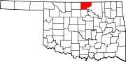
Tonkawa Tribal Housing is a census-designated place (CDP) in Kay County, Oklahoma, United States. It was first listed as a CDP prior to the 2020 census[2] and is inhabited by members of the Tonkawa Tribe of Indians of Oklahoma.
The CDP is in southern Kay County, 3 miles (5 km) east of the city of Tonkawa. In addition to residences, the CDP is home to Tonkawa Casino. The community is bordered to the east by the Chikaskia River, a south-flowing tributary of the Salt Fork of the Arkansas River.
Demographics
| Census | Pop. | Note | %± |
|---|---|---|---|
| 2020 | 310 | — | |
| U.S. Decennial Census[3] | |||
References
- v
- t
- e
Municipalities and communities of Kay County, Oklahoma, United States
County seat: Newkirk
- Nardin
- Peckham
- Tonkawa Tribal Housing
- White Eagle
communities
- Oklahoma portal
- United States portal
 | This Oklahoma state location article is a stub. You can help Wikipedia by expanding it. |
- v
- t
- e


